

The summer season has slowly given way to fall, and Indian summer still tempts us to take trips into nature. But for us, the season never ends! So, before you head out into the fresh air again, here’s a brief summary of what we’ve accomplished over the past few months. We’ve significantly improved the web route planner, fixed the integration between Locus and e-bikes with Bosch motors, and added a simplified route planner to the iPhone version. And now, in more detail:
Locus Map Web Just Got a Little Better
The web planner has once again taken giant strides toward matching the capabilities offered by its more advanced Android version.
Plan using shaping and via points along the route
You create a route in the route planner using what are called shaping points and via points. The difference between them is that while shaping points are used only to determine the direction the route planner takes, waypoints are places you really don’t want to miss on your trip. These are usually LoPoints (natural and architectural landmarks, restaurants, etc.) or your user points (such as geocaches). You can now create a viapoint from a shaping point—and vice versa—on the website. Or you can insert a viapoint anywhere along the route.
You can assign a custom icon or description to a viapoint. The icon will appear in the itinerary and on the elevation profile.
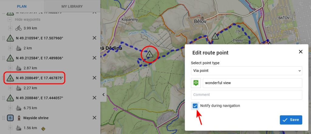
In addition, viapoints are displayed in the route panel and in the detailed list, which you can open in a separate window. This list shows the distance between each viapoint, and you can center each one on the map or copy its coordinates.
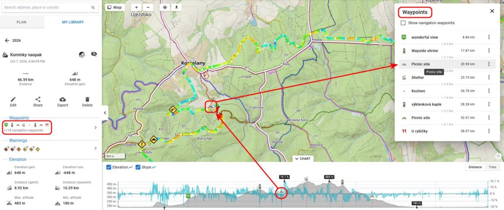
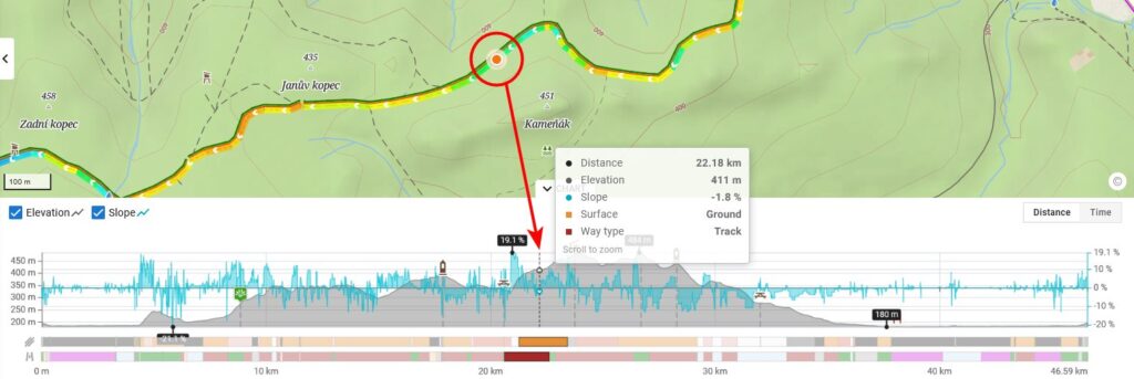
Now you know what kind of surface you’ll be riding on
Each route includes a graph showing elevation gain and slope gradient. For the planned routes, we’ve added two bars with color-coded surface types and trail types. When you hover your mouse over a route or the graph, all the data for that specific location will be displayed—distance from the start, elevation, gradient, surface type, and trail type. So now you know exactly which parts of the route will be on a third-class paved road and which on a gravel dirt road, and what it will be like to ride on that muddy trail with a 20% grade. And based on that, you can then adjust your route accordingly.
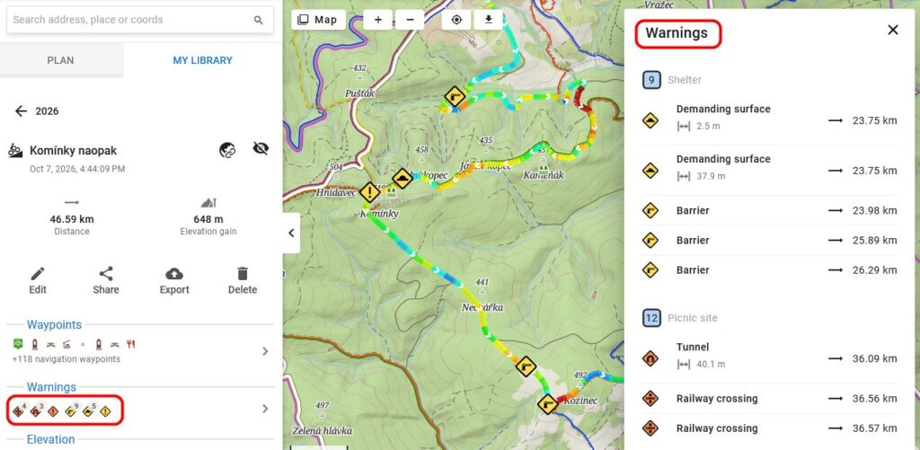
Watch out for obstacles along the route!
Rough terrain, a barrier, a railroad crossing, heavy traffic on the road… The route planner can now warn you about these and many other hazards right from the comfort of your living room. It displays them directly on the map, in the route panel, and also in a detailed list that you can open in a separate window. The app also displays these warnings during navigation (if you choose).
Style your route line however you like
You now have the same options as in the mobile app:
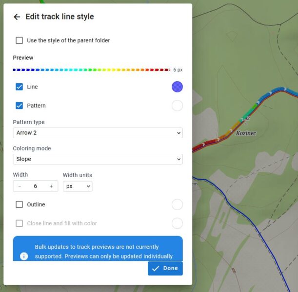
Choose any color, opacity, pattern, and outline. The selection also includes dynamic coloring styles based on speed, route incline, heart rate, or cadence. Of course, styles can be inherited from route folders.
As for the incline, the dynamic color scale varies from the app for now, but we’ll fine-tune that over time as well.
What’s New on Android
Locus Map version 4.36 once again brings a large set of changes and fixes, the most significant of which are as follows:
The connection to Bosch e-bikes is finally working
If you ride an e-bike with Bosch Smart System technology, we have good news for you—it’s been fixed. The Locus Map app already communicated with these bikes, but only through an impractical workaround—you had to pair the bike in the Android Bluetooth settings and launch the Bosch Flow app first, and even then, data on the assistance mode or motor power wasn’t available; only basic data such as speed, cadence, and rider power.
We had to completely overhaul the connection method, and once we succeeded, we were finally able to add what had been missing: the assistance mode and motor power, in addition to the data you already had available. In addition, version 4.36.0 adds the remaining range for the currently selected assistance level, along with a few other minor tweaks. Hopefully, it won’t give you any more trouble!
Augmented reality just got a little smarter
Augmented reality (AR) in Locus Map displays map points in the real-world landscape on your phone’s screen via the camera. It was previously available as an add-on; since the last version, it has been built into the main app.
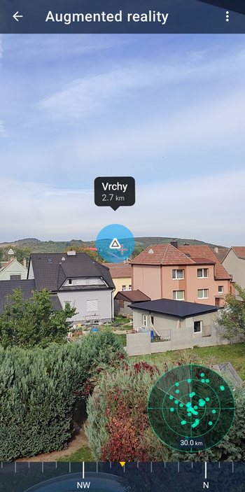
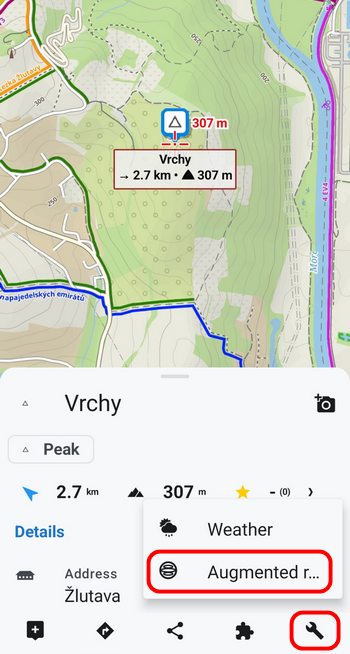
The biggest new feature is the ability to load nearby locations from our LoPoints service, so you can see peaks, landmarks, and other points of interest even in areas where you don’t have your own map data. In AR, you can also view any point directly from its tool menu and display it similarly to a navigation destination.
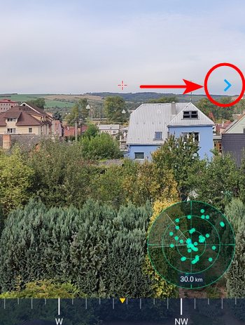
We’ve also added a warning about compass distortion: if something in your surroundings is affecting your phone’s magnetic readings or if the compass needs to be calibrated, the AR view will now alert you. And if your destination is outside the screen, a small arrow at the edge of the view now shows the direction you should turn.
Count Your Steps
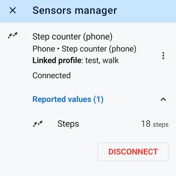
Among the many minor updates, let’s at least mention the built-in pedometer. Count your steps using just your phone (no additional sensor is needed); the step count is now included in exported GPX and TCX files as well as in the FIT format, and can be retrieved when importing GPX files.
Plan your trips on your iPhone, too
The much younger sibling of the Android version received a major new feature over the summer—a route planner. Although it’s much simpler and works only online, it’s a big step toward other features that rely on route generation, such as navigation.
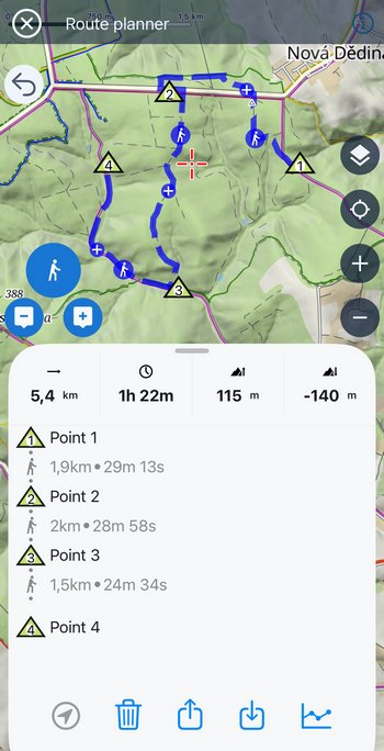
We’re still fine-tuning the planner, and we’ll publish a detailed article about it when the time is right.
Indian summer is slowly giving way to fall, and the colors of the season are just around the corner! So don’t miss out by sitting at home on the couch—head out into nature, with Locus Map, of course. Thank you for using our app, and we appreciate all your feedback.
Frequently Asked Questions
What is the difference between a shaping point and a viapoint, and how do I change one to the other?
A shaping point simply tells the route planner where to go. A viapoint is a place you actually want to visit on your trip—typically a LoPoint or a point you’ve created yourself. Now on the website, you can convert a shapingpoint into a viapoint (and vice versa), and you can place a viapoint anywhere along the route. You can also assign a custom icon and description to each viapoint, which will appear in the itinerary and on the elevation profile.
Where do you get the surface data from, and will I be able to see it for my recorded routes as well?
Like our other map data, we source this from OpenStreetMap. We’ve added colored bands indicating surface and road type to the planned routes only—when you hover your mouse over a route or the graph, you’ll see the distance from the starting point, elevation, gradient, surface type, and road type for that location.
Will route warnings (roadblocks, railroad crossings, difficult terrain) also appear in the mobile app?
Yes. The planner shows them directly on the map, in the route panel, and in the detailed list, and the app can also display them during navigation—if you enable that feature.
What do I need to connect to a Bosch e-bike?
A bike equipped with Bosch Smart System technology and Locus Map version 4.36 or later. We’ve completely redesigned the connection process, so you no longer need to go through the Bosch Flow app. You can now also see the assist mode, motor power, and remaining range for the currently selected assist level.
Do I need an external sensor to count my steps?
No, the pedometer is built-in and only requires the phone itself. The step count is included in exported GPX, TCX, and FIT files, and is loaded back in when a GPX file is imported.
androidaugmented realityiOSLocus Mapnew releasenewsroute plannersurfacesviapointsway types


3 Comments
Já mám nejstarší locus a Mega spokojenost. Vychytávky nepoužívám.
Ich sehe gerade das Bild hier vom webplaner. Da sind beim Linienstil die alten Farben für Steigung zu sehen. Das sollte Einheitlich mit der App sein.
Excellent work team. Great set of new features.