
After two months of hard work, we are releasing a new version of your favorite outdoor navigation system. It brings again an incredible amount of modifications and improvements. We pick the biggest highlights from the changelog:
- the new route planner
- new in LoMaps
- unified system of LoPoints
- possibility to highlight selected categories of LoPoints above the map
- new notification centre
Now let’s take a closer look.
Planning routes faster and more clearly
As you already know, the planner draws a route based on the selected route profile. What is a routing profile? It is a set of certain parameters that the planner uses to plot a route on the map. It can be a means of transport, such as a car or a bike, but also a sport activity, such as walking or cross-country skiing.
Based on your numerous suggestions and our monitoring of the planner’s use, we have undertaken a major transformation of the route profile selection and planning logic. Clicking on the profile selection button will now take you directly to a menu of all profiles for the selected router. Click on the selected profile to activate it, and the entire route will be recalculated according to your new selection:
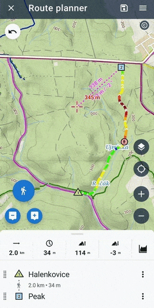
Data analysis reveals that most routes are planned with a single activity, requiring a quick modification of the entire route with a different profile to view it all in a new context. We’ve now sped this up to two clicks.
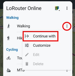
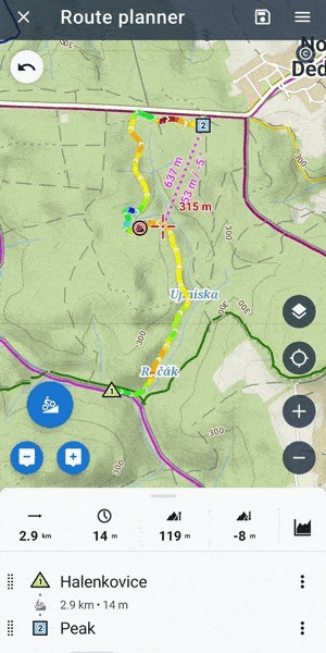
A different profile for each segment
Many of you are planning a combined route. For example, you want to drive to the start of the hike and then continue on foot. Of course, we have the option to choose a profile for each route segment separately. We just moved it to the action menu. Click “Continue with…” to change the profile for the next route segment, not the whole route.
What about custom settings?
Of course, it wouldn’t be Locus Map if it didn’t offer additional options to customize the app. Each LoRouter profile (except for manual mode) includes the ability to change various route calculation and route time estimation parameters. Just hold your finger on the profile select button, and additional setting options will appear:
TIP: As a proper geek, you can place the button to change parameters directly on the planner’s desktop. A long press then quickly changes the profile to manual mode:
Detailed instructions on how to use all the options of parameters and their settings when planning your trips will be discussed in a future article.
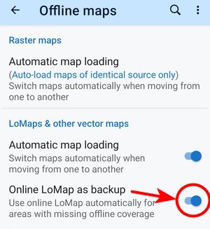
LoMap always on display
With the new Locus Map, you’ll never drive out of an area covered by LoMap and see a blank screen instead of a map. Once the app detects you’re off the map, it automatically switches to online mode and streams map data from the internet. You can, of course, turn this option on or off in the settings:
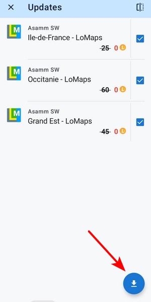
Bulk update
Those of you who use offline LoMaps will appreciate the ability to update multiple map packages at once. You can choose from a list or update all of them at once.
Locus Map Lite now also offline
This news isn’t Android-related, but we still want to brag a bit: Locus Map’s little brother for iPhones and iPads, Locus Map Lite, can also work with offline maps, as we wrote here. So if you have Apple friends, feel free to tell them.
Online&offline LoPoints in one
LoPoints, touristy and interesting places on the map with lots of information and photos, used to be available separately in online and offline versions, and were also switched on separately above the map. We’ve managed to simplify this tremendously – everything is hidden under one button in the content panel, and you don’t have to worry about whether you have an internet connection or have downloaded the right offline LoMap.
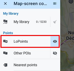
Of course, you can turn off the automation in the settings and display online or offline LoPoints separately. Important note: the new system only works with the latest LoMaps, so make sure you update them.
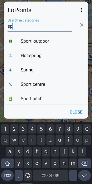
Highlight the selected category
If you arrive in an unfamiliar city and need to quickly see all the places to eat on the map, just tap the content panel and select the appropriate LoPoints category:

Since there are a plethora of categories available, you can also search them in full text:
What about points of interest from other sources?
You can also display other databases in Locus Map, for example, from OpenAndroMap. There is a separate display button for these in the content panel. Here you can also find LoPoints from older versions of LoMap:

So you don’t miss anything
We’ve created a brand new notification system for the actions the app takes – when and how it downloads maps, backs up your routes and points, syncs with the cloud, and more. You can also get a look at your notification history:
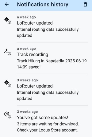
We’ve also added a button for quick access to manage system notifications, where you can set everything up so that you’re only notified of exactly what you need to know.


53 Comments
You are great
Ich versuche leider vergeblich, die App auf das Display des Autos angezeigt zu bekommen. Wie geht die Verknüpfung mit Android Auto? Das Appsymbol (blaugrauer Routenpfeil) von Android Auto wird mir auf dem Handy (Locus-App) angezeigt, aber eine Verbindung mit dem Fahrzeug Ford Transit gelingt nicht.
Android Auto, dass wäre mal ein Feature was die breite Masse von Anwendern fröhlichnstimmen würde.
Unfortunately, Google still refuses to approve Locus Map for Android Auto officially - we've been struggling with them for half a year. You can install an APK with AA implemented from https://bit.ly/lmVersions but not all car devices accept it.
Stalin Silvano skislñ
Will it support Swedish official map from agency: Lantmäteriet? If not the app is not so useful for swedish people like me. Also Norwegian statkart is important for Norway residents and me and a like when travelling in Norway!
Will it support Google Auto?
Br Sweden
Hi
Norwegian Statkart is already in Locus Map !
Chart - WMS - Europe - Norway
It looks like Lantmåleriet (SWE) is missing for Sweden...
Christer Nervik
(From Norway)
Unfortunately, Läntmateriet decided to change their map-providing policy and their maps are no longer available in Locus Map officially. But you can add a WMTS channel with your private key, which you can get for free. More info at https://help.locusmap.eu/topic/37755-sweden-topo-mapp#comment-152954
Ich nutze nur Locus Map Classic mit openandromaps und Brouter, was für mich keine Wünsche offen lässt. Keine LoMaps und ähnlichen Käse der jährlich eine Menge Geld kostet, was ich mit Classic genauso nur günstiger habe.
Wie wird man diese Benachrichtigungen los?
24 Euro im Jahr(!) für das Gold-Abo sind wirklich überschaubar. Und da sind die LoMaps mit drin, also keine Menge Geld. 2 Euro im Monat dafür, dass die App auch weiterhin weiterentwickelt werden kann. Geiz ist geil oder nur nicht richtig hingeguckt?
24 Euro pro Jahr sind in 10 Jahren 240€ gegenüber regulär 10€ für die Classic Version, die kann ebenso offline Routing und auch sonst kaum weniger. Sie ist ausgereift. Was ist daran geizig, ist doch ehrlich bezahlt. Wenn du gerne für alle möglichen Services (also nicht nur Locus) pro Jahr bezahlst, ist das ok. Nicht jeder kann oder möchte das. Du bist ja zum Glück auch nicht das Maß aller Dinge, gell?
Ich heiße auch Michael und zahle dem Locus-Team gerne den jährlichen Goldversions-Obulus.
Und nutze OAM fast ausschließlich.
Fein. Das freut mich für dich und das Locus-Team, aber nicht bei jedem sitzt das Geld so locker wie bei dir. Dafür habe ich ja auch deutlich geringere Ansprüche.
Du bist ja zum Glück auch nicht das Maß aller Dinge, gell?
Das habe ich auch nie behauptet. Ich schrieb oben, dass ich keine Werbung für ein Produkt, das ich nicht möchte. Scheint zu schwer verständlich zu sein?
👍
Toll was alles im Planner der APP möglich ist, das sollte bitte auch im Webplaner ungesetzt werden!
The route planner on the web will use the same logic, features and a similar UI. We're working on that too.
When you make overlaying maps more convenient? Make slider of opacity small and dragable, so user can see clearly poins of interest on old maps, and compare with current vicinity from satellite. All treasure hunters all over the world would be happy
The overlay has a draggable slider with an all-screen view of the map for fine opacity tuning.
Hi!
Why was the display block of squares/tiles from the statshunters plugin introduced? It was very convenient.
Update your Chrome. The plugin is working again.
Danke für die beste Adventure App! Ich liebe euch App und die LoMaps. Mein gesamtes Snowboard Freeride und Mountainbike Enduro Leben funktioniert Dank euch seit Jahren : )
Thanks! Have fun!
Wieder auf ein altes, funtionierendes Niveau zurück wäre besser.
Vorherige Version,
- zoomen mit Galaxy Tab S4 kaum möglich, interessanterweise bei geringer Auflösung,
- PKW-Routing sagt jetzt jede Kurve an, dafür keine Kreisverkehre, Abbiegungen, ...
Hi, if you have any issues with the app, please contact us at https://help.locusmap.eu and send a detailed description of the problem. We'll be happy to help.
Wo hast du den Track für das Routing geplant. Das hört sich an wie wenn du eine Fremde gpx verwendest und auf Navigieren gehst.
Thanks a lot for these improvements, helping to use the much powerful application on the market.
Personally for me the route planning journey became longer. When I plan the route I move from point to point, taking current part of the route into account: there is no link on the map (but I know there is a path) - switch to the direct link profile, put the next point, switch back to the 'vehicle' profile; there is more 'gravel' part of the route - then switch from 'road' to 'gravel' profile in order no to have a lot of excessive suggestions via a highway.
I do not need to recalculate all 50 points of my route each time I switch the routing profile for a particular part of it (so now there are +2 clicks to chose the 'Continue With' option, each time).
I cannot even imagine who ever might want to switch from 'car' to 'walking' the whole route so OFTEN that 'Recalculate All' command was considered so energy-consuming operation.
Huge disappointment.
Sehe ich genauso. Auch für mich ist das keine Verbesserung des Workflow. Ich nutze den manuellen Modu, wenn Locus einen existierenden Weg nicht kennt. Und ich habe jetzt 2 statt 1 Click
Nein, lange auf das Plus und es macht einen manuell Abschnitt
Yes. I like progress but here it may be more useful to just have an additional 'switch whole route to profile x' function.
Just because most people's routes use only one profile doesn't mean they recalulate the whole route often. Isn't it more like to plan with one profile from the beginning and then change a few sections that you like to keep that way?
Hi, we hear your feedback. We considered some UI switcher to choose behavior when selecting different routing profile, but so far, we didn't find suitable UX solution for this which meets also our other requirements.
Also in consideration was detection when track is already planned by more than one type of routing profile which might alter the behavior or throws at least some confirmation dialog when selecting other profile. But it wasn't ready in time for release.
We didn't want to delay this change because the truth is that for majority of users this is much more intuitive behavior and in the same time we didn't increase number of steps/taps when changing routing profiles for separate segments of planned route - maybe except switching to manual mode and back. (You just need to get used to new "flow".) But the topic is still open for us and we hope after some tweaking your disappointment will go away. :-)
What about hard work on the connection between Locus and Bosch e-bike ? Hm? 🤣
Locus wants this but Bosch won't release the connection.
Hi, unfortunately, Bosch refuses to communicate regarding our proposal for cooperation so the connection won't happen shortly, if ever.
I am currently overlanding in Romania Strategica road and of course I use my favorite Locus app. Great tool! Keep great work! Thank you.
Thanks! Enjoy your trip!
I love the more efficient selection of profile in route planing! And I'm looking forward for the next updates of my 30+ LoMaps, where I will only do a few clicks instead of over hundred. Thank you for this great update!
Hi, after the latest update:
1. WMS maps need to be reloaded every time I start the app.
2. Overlay maps only work from zoom level 17; it's not possible to set them, for example, from 19 to 23.
3. When I import a GPX file from the archive and open it in Locus, I have to go back several times before it properly imports and offers options like "show on map". This part has never really worked as it should.
Love the app 😘
Hi, if you have any issues with the app, please contact us at https://help.locusmap.eu and send a detailed description of the problem. We'll be happy to help.
Was meinst du wie viele Apps es gibt, die nur "2 Euro im Monat", soviel wie 3 Bier im Monat usw usw kosten, viele auch noch wesentlich mehr. Wenn du damit einmal anfängst bist du verloren,da verliert man völlig den Überblick.
Verlässlich ist LM im offroad- und Wanderbereich.
Leider aber nicht in der Straßennavigation.
Planungen über 500 km kaum möglich; Abbruch wegen Zeitüberschritt,
Rückführungen auf die geplante Route über teilweise abstruse oder nicht im Straßenverkehr zulässige Wege
Abstürze der App
Schade, dass die Performance hier nicht verbessert wird.
Hi Olaf, Locus Map is primarily an outdoor navigation for hikers and bikers. The car features are limited and not optimized. What router do you use when there are timeouts? We don't register any timeouts with our LoRouter.
Hallo Locus-Team, leider sind bei dem neuen Update viele POI bei der "Zusammenführung" verloren gegangen. Ich habe z.B. keine Anzeige mehr für Kirchen / Kapellen oder auch Burgen / Schlösser. Das ist sehr schade, da diese sehr wichtige und markante Punkte in der Landschaft sind.
Hi, there was an outage on our LoPoint server due to an unexpected update engine malfunction. The issue has been fixed and the system is recovering. We are sorry for this inconvenience.
My LM in new version (gold subs) doesn't find rout on a highway, but always finds wird detours. Before all was good. Why it's like this now?
Hi, if you have any issues with the app, please contact us at https://help.locusmap.eu and send a detailed description of the problem. We'll be happy to help.
Sehe ich genauso. Die App wird ständig weiterentwickelt und da sind sehr talentierte Leute dahinter, die auch noch zuhören. Da zahle ich aus Überzeugung die Gold Version.
Hängt euch beim Desktop-Routen-Planer mehr rein.
Leider kann ich zu wenig Englisch, so dass ich aus den Kommentaren nichts Wesentliches herauslesen kann. Kann mir jemand in einfachen Worten (auf deutsch) sagen, ob die Locus Map Classic komplett abgeschaltet wird oder ob sie zumindest noch einige Jahre genutzt werden kann, so wie sie gerade ist. Ich brauche nur von Zeit zu Zeit eine aktualisierte Karte (LoMaps) zum Herunterladen, speichere die ein oder andere Route (gpx-Datei) und begnüge mich ansonsten damit, den eingezeichneten Fahrradrouten zu folgen. Wenn dies weiterhin ginge, würde ich bei der Classic-Variante bleiben.
Hallo Josef,
Locus map Classic wird nicht "abgeschaltet" Es läuft auf Deinem Smartphone, bis Du zu einem neuen Smartphone wechselst. Dann wirds schwierig. Angeblich gibt es Locus Map Classic als sogenannte APK-Datei in irgendwelchen Locus-Archiven. Habe dies jedoch noch nicht gefunden. Wenn es die gäbe könnte das genannte Programm auf einem neuen Smarphone installiert werden, und alls wäre gut
Ich werde weiterhin nach dem Programm als APK-Datei suchen, da auch ich in die Situation kommen werde, in ca. 3 Jahren zu einem neuen Smartphone zu wechseln.
Hi, Locus Classic is still available on Google Play: https://play.google.com/store/apps/details?id=menion.android.locus.pro for the current users. The APK is available on our public repository at https://bit.ly/lmVersions (mentioned in the blogpost)