Custom points, geocaches, displaying several routes at once… Finally, this massively expected functionality, which we call the ugly word “multicontent” in the office, is fully available in our web planner-library at web.locusmap.app.
Sync
To get your user content on the web, you need to sync your Locus Map with the cloud. As we wrote here, here and here, a Premium Gold subscription is required for this and you have to start the first synchronization manually. Then just log in to web.locusmap.app with the same account as in the application and you can browse your routes and points.
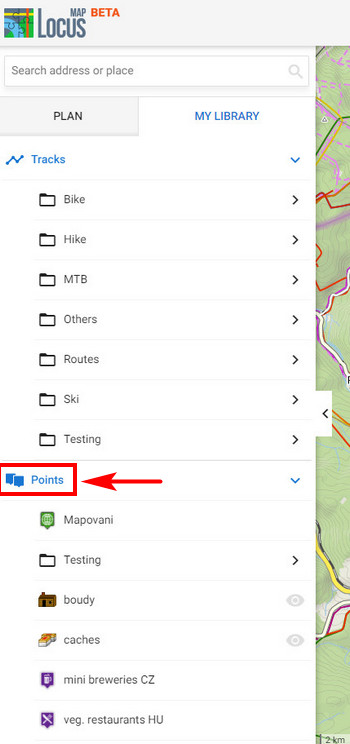
Show points on the map
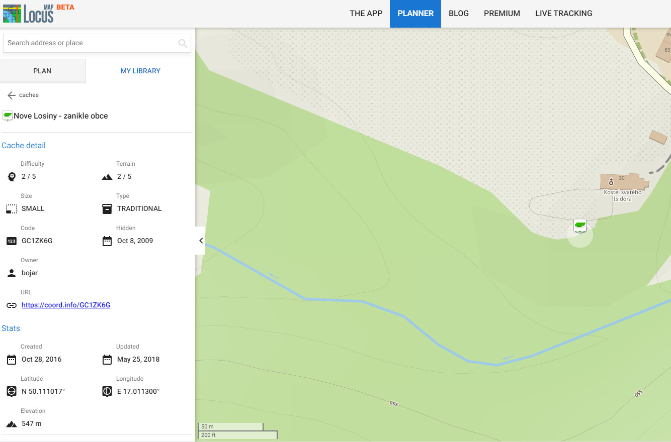
The Points category has been added to your web library, displaying all your user points of interest, caches, etc .:
You can add your points on the map in whole folders:
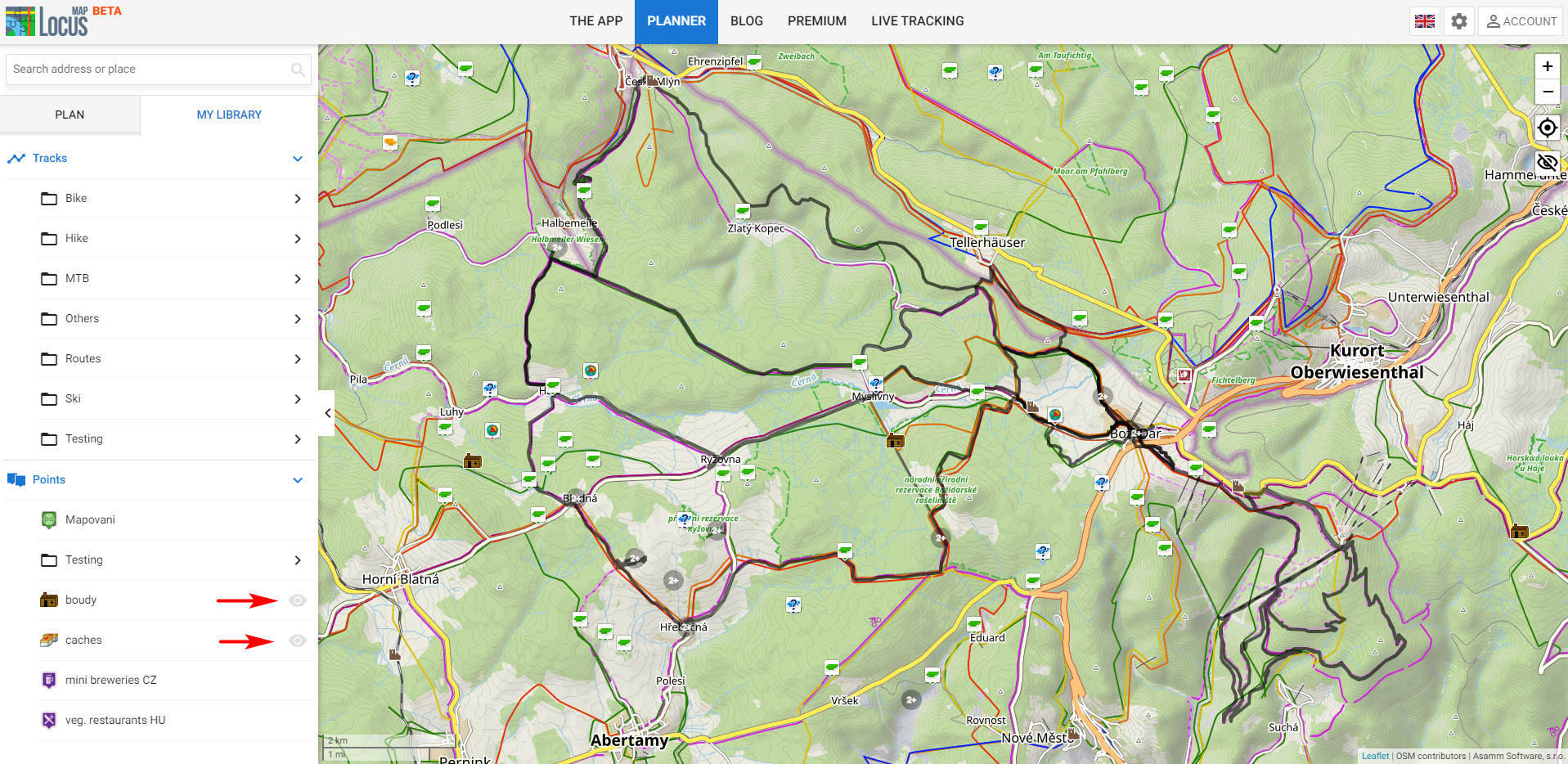
You can “activate” as many points as you want, but they may not all appear above the map at once (there’s a limit against browser congestion). In addition, where points overlap, the browser concentrates the points into groups. So in order to see a specific point on the map, you need to zoom in on the map.
You can find a specific point in a folder and click on it to display it on the map. At the same time, the details of the point will show on the left:
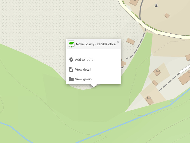
When you move the cursor to a point, a popup opens offering to add the point to the planned route, view details or the entire folder:
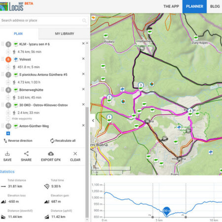
A geocaching trip
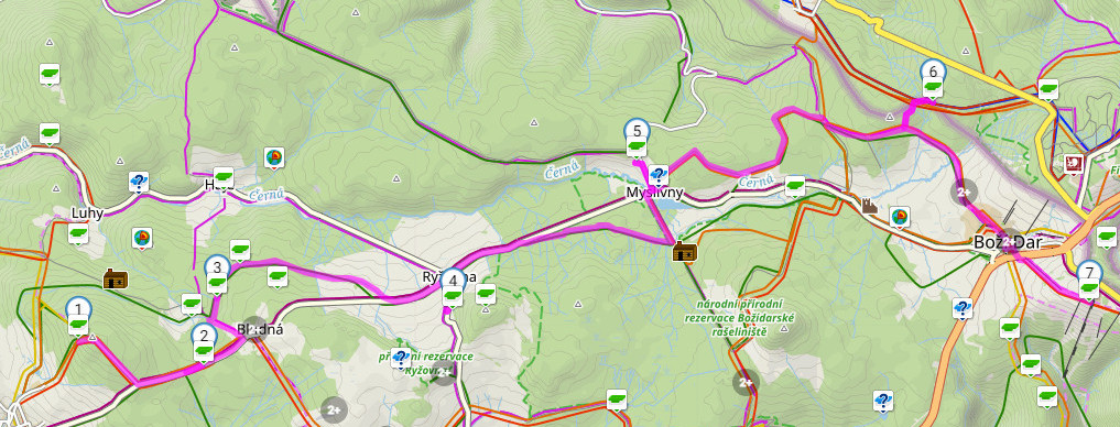
Geocaching players quite often use Locus Map, in which they have a lot of caches downloaded. Thanks to the new functionality of the web library, it can now display these caches in the web route planner and plan the fun for the whole day.
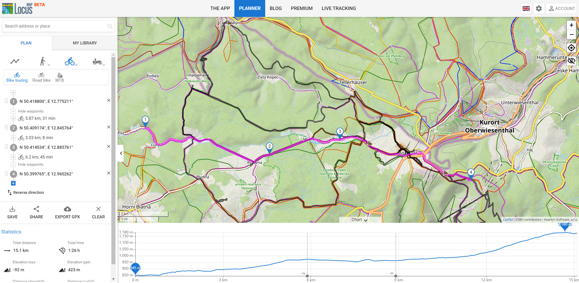
Just select the appropriate activity (on foot, by bike, by car, it can also be combined) and gradually add caches to the route:
The panel on the left shows an itinerary with distances, estimated time on the route and other statistics, below the map is a graph of elevation with marked stops:
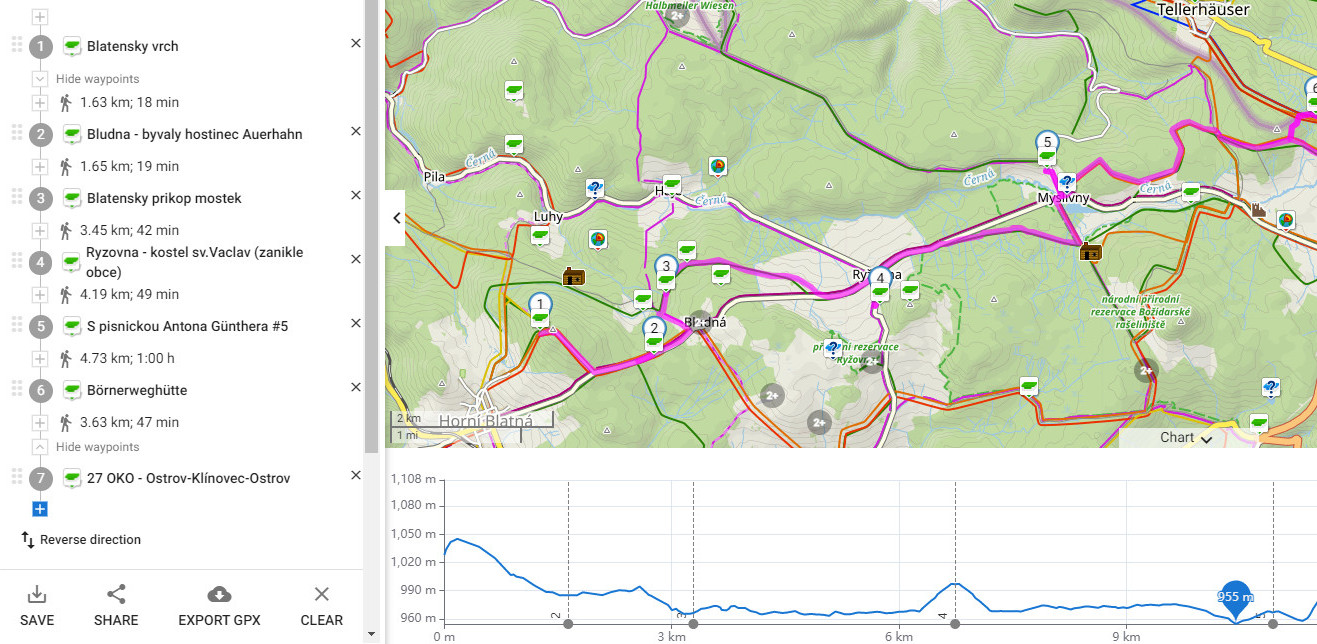
Now you just need to save the route, automatic synchronization will take care of moving it to the mobile application. And you can go.
More routes on the map
In order to be able to plan a route that you have not yet taken, it is good to know where you have already traveled. So show on the map all the trips you have already been on. In the web library, select all the routes you need. They will be highlighted above the map and you can start planning:
What else can you look forward to
We’re still working hard on the web planner, so you can expect more tweaks in the future. For example:
- more options for sharing routes and points
- filtering, sorting routes, points and searching for them
- graphs with additional route information
- display of road types and surfaces
- summary statistics of routes in folders
- import and more variants of export of routes and points, etc.


29 Comments
Really loving the LM4 :)
Nowadays - and especially during summertime - watersports are more and more important.
Ability to plan a route (and see the stats!!!) on waterways would be priceless - I do SUP a lot and like to plan the daily route but on winding rivers, streams it is rather difficoult as it is viable only by 'freehand'. would really be great if there were a 'waterways' option as well - thx in advance!
Daniel
Hi Daniel, the routing engine BRouter cooperating with Locus Map has "river" profile in its portfolio. You might be interested to test it...
Thanks a lot for these improvements! Together with the ability to change existing routes, this has made the Web Version so much more useful.
For me the only missing feature now is the ability to see slope / gradient % of planned routes in the chart, so I can plan routes with a certain max increase for bicycle more easily.
Keep up the good work, Locus is worth every cent!
As you can see in the article, we are still working on the web planner and more parameters in the chart are also planned.
Hi, thx... my comment is: since I am recording all my movement outside home, syncing to server is a privacy issue for me. Can do it on the day when you allow for including/excluding of folders...
thx
Hi, syncing to a server is strictly private and the data on the server is accessible only to its owner upon secure log in.
Thanks a lot for "More routes on the map - Show all the trips"
but it seems:
- I have to select/show the route one-by-one; is there not a multi-selection button on the top?
- the displyed/selected routes on the map appear all with the same black color.
They don't maintain the original color I have on the Locus app.
This is too bad because I have different colors (in the Locus app) for routes already done and routes only planned but still to be done.
Thx
Hi Roberto,
- track multiselect is planned to be implemented later
- user track coloring - also later if we don't find any problem with it.
Thx :-)
I would like to create folders in web.locusmap.app and transfer multiple tracks/points between them. It would be really appreciated.
Hi Honza, all this is planned. For now, you can do so in the app - the auto sync gets it to the web.
Hello Locus Team!
Thank you so much for this great functionality!
It's works really good!
Everything synchronized from my both Locus apps.
Only one question - how to set my password for login by using email account.
There is no option for create, management or reset email password.
For now I can login only by Google. Din't checked Facebook login.
Hi, select "e-mail" when logging in Locus Store in the app. If you put in the wrong password an option to restore your password emerges.
Skvělý update. Co mě trochu chybí, je možnost jednoho tlačítka na zobrazení všech tras ve skupině.
Tlačítko na dávkové zobrazení tras bude. Nicméně z bezpečnostních důvodů jej ošetříme nějakým limitem, jelikož prohlížeč by třeba 100 tras najednou nezvládl došlo by asi k pádu webové app.
Hey,
good job guys. I plan routes based on caches locations quite often so it will be useful defintely. However two remarks and requests at the same time. I'm missing filtering option because currently I have caches grouped into two folders: one for GC and one for OC. And I can only switch visibility of caches on whole folder level and not filter out on additional criteria. But I believe that's on the list to do, right?
Additional thing is how caches are presented on the map. There's a nice presentation of found and not found ones, however I also found out, that archived caches are shows as not found - same way as active ones. Since I'm not removing archived caches from the folders, would be great if they're also marked differently from active ones and disabled maybe? Ideally, if they are shown also based on the type such as it is in Locus, but that's not a must for me but filtering out archived caches or at least showing them differently is quite significant cause at the moment I can only check if it;s archived by going into the details.
It is absolutely great functionality. Make planning my travels in the easyest way. The only thing which I miss is an ability to manage waypoints via web. Do you have a plan to implement it?
Hi, yes, that is planned.
Great features already with this online route planning tool !
When you write (for what's next):
- graphs with additional route information
- display of road types and surfaces
Do you intend to clearly display the "sac_scale" attribute for all paths ?
This is really the information I am missing when planning hiking trips, to make sure I will avoid engaged alpine hiking paths when not equipped for them or bad season/weather.
This information of utmost importance is missing from both the map rendering (there should be colors to highlight difficult/dangerous paths) and from the route planning summary.
It is a shame that we need to use third party maps instead of LoMaps to get a good rendering of the path difficulties. I am sure you can do something to improve this point :-)
Good point, thanks for it. We're definitely thinking about it and the way how we could implement it.
Hey,
great job guys.The only thing which I miss is to manage waypoints via web.
Witam
mam pytanie jak zsynchronizować bibliotekę na komputerze bo niestety
odnośnik ( tu i tu) nie działa
Hi, start with the app. More at https://docs.locusmap.app/doku.php?id=manual:user_guide:sync
Bonjour,
Je planifie mon voyage entre Angers et Jerusalem à pied à partir de mars 22.
Est il possible de préparer et sauvegarder mes projets de chemin et de les transferer sur l'application pour Android.
Si cela est possible j'achète l'appli version Pro et je peux travailler sur le PC?
je pars avec 3 compagnons est il possible de partager l'appli sur 3 telephone ?
merci de vos réponses
Cordialement
Denis
Hallo, ich benutze den Web-Planer nun einige Tage. Ich würde mir wünschen, meine alten gpx-Dateien, die ich auf meinem WIN 10 Rechner habe zu importieren.
Gruß Bernd
Hi Bernd, the import is planned to be added for the new season. Until then, import your GPXs to the mobile app and synchronize with the web library.
Web-Planer und Routenbibliothek - sind tolle Features, ich selbst nutze jedoch seit längerem den Nox Android-Emulator unter Windows. Läuft super und ich habe die volle Funktionalität von Locus Map auf meinem Windows PC - mit Maus, Tastatur und großem Bildschirm. Vielleicht wollt Ihr euch das mal anschauen, auch Microsoft hat vor, einen Android-Emulator unter Windows zu veröffentlichen. Da ergeben sich dann ganz neue Möglichkeiten...
Danke und beste Grüße
Marco
Yes we know about Locus Map running smoothly on Android emulators, we use them everyday for testing. We wrote about it six years ago https://www.locusmap.app/how-to-use-locus-map-on-a-pc/
This looks great at my first glance of the web based map / route planner.
I would MUCH rather organize and maintain large folders of points / tracks on a web based desktop interface than trying to maintain that large set of data on my phone. Google Maps was a completely lost cause trying to organize thousands of waypoints from travels. Locus has been great but I really want a web based tool for organizing them and keeping them synchronized with the mobile device(s) I use.