
We’ve taken our time with the new version of your favourite outdoor navigation app – we wanted to give it a proper polish and bring some major improvements before the start of the 2024 season. And we’ve done it – we’ve got a brand new route planner with an integrated dynamic itinerary linked to the route navigation, the ability to put the app directory in a freely accessible storage area, and lots of other nice touches.
Navigate with the planner
Sophisticated route planning is one of the cornerstones of Locus Map’s features. That’s why we’ve done a lot of work in recent months on the planner as well as routing, profiles and other setup parameters. However, the “Navigate to” function could not use this potential in its original design and defacto duplicated the planner function in a somewhat clumsy way. So we decided to combine these two functions into one.
So how does it work now?
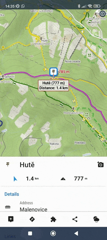
- Choose a destination – via “Navigate to”, by direct selection on the map (point of interest, your own user point, long-tapping any place on the map…), in your library, from a search result…
- Tap on the navigation button – the route planner will start and a route will be generated in the last used profile from your current location to the selected destination. Now you can change the profile (activity, means of transport), add waypoints on the route, check the elevation graph, and surfaces, and just take full advantage of the comprehensive route planner. Or don’t, and go straight to the next step:
- Start the route navigation – the button in the top bar starts the selection between navigation and guidance, and then you’re ready to go.
What are the advantages?
- Removing a redundant route planning interface for navigation
- Simplification of the user interface
- Linking fast navigation from A to B with a comprehensive planner while maintaining the speed of its launch
- Quick possibility to edit the route, add waypoints, recalculate in another router or profile (large selection of profiles and their customization through many parameters) plus other benefits of the route planner (elevation graph, types and surfaces of roads…)
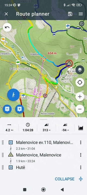
Plan routes with an itinerary
The itinerary has been part of the route planner for a few years now. However, until now it has been somewhat neglected, with extra input from the top bar. And since it is a live part of the UI in the web planner, we decided to make it more visible in the app as well.
How is the itinerary in the planner used now?
- The bottom slide-up panel, the so-called “bottom sheet”, now contains two tabs that are switched by a button on the top right: charts and itinerary. The default is to display the itinerary, even though there is nothing in the planner yet. This is because you can also select the start and finish directly in the itinerary.
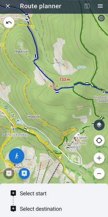
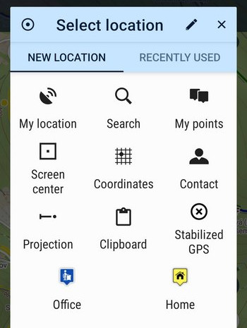
- You can choose the start as before directly on the map or in the itinerary – tapping on start will display a menu of all options:
- You can add additional waypoints (shaping or via) either directly on the map or in the itinerary:
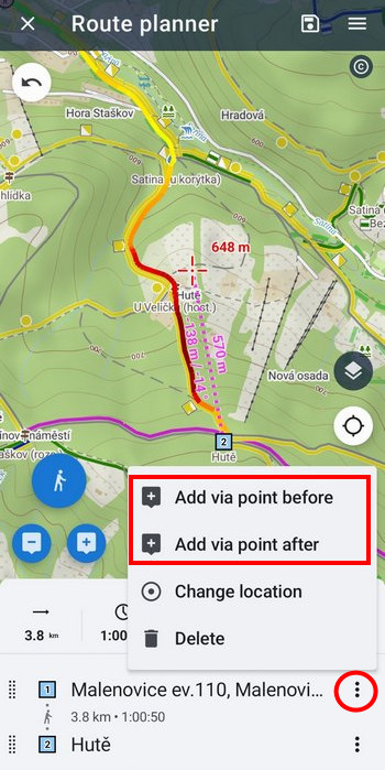
- Use the itinerary to reorder, delete or reposition waypoints quickly.
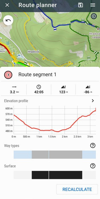
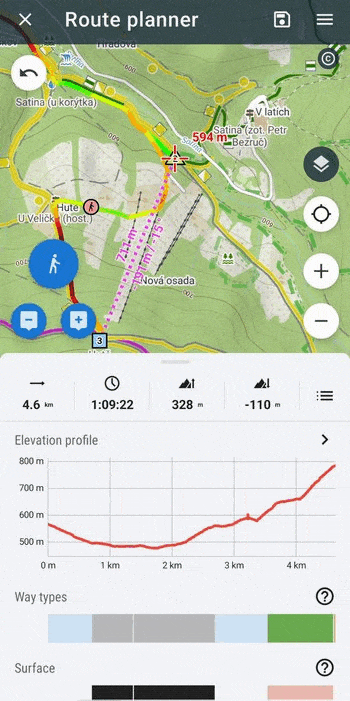
- Tap between waypoints in the itinerary to see intermediate route segments that can be recalculated in another profile:
- Of course, on the map you have a fully editable route in addition to this.
So what are the advantages?
Route planning options are now more handy (they used to be hidden in menus), there are “more” options and something different suits everyone. You can plan on the map, in the itinerary, or combine both. The Itinerary is now an equal planning tool to the map.
Plus a little bonus – you can view a detailed route graph directly from the planner:
Photos from Locus Map in Google Photos? YES!
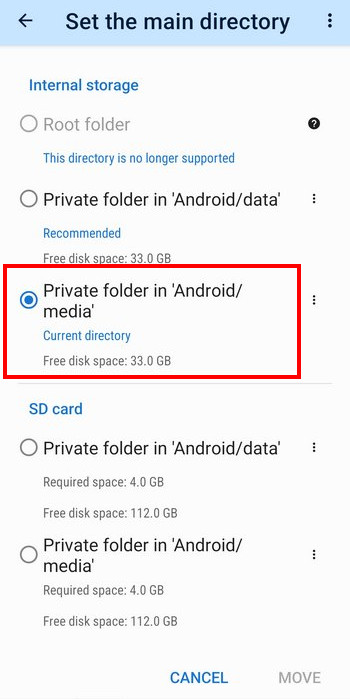
And not only there, and not only photos. Thanks to the new option to move the app’s main directory to the Android/Media sector, the system gallery gets to them too. And you can easily access other app data, the geocaching folder, local exports of geocaching logs, and so on.
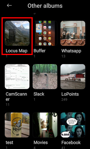
It’s a refreshing breeze of freedom since the fateful moment in Android 4.4 when apps were forced into the impenetrable private Android/data sector. While Android’s recommendation is still to use the Android/data sector, you can easily set your main directory to “Private folder in Android/Media” in Locus Settings > Backup & File System > File System Manager and forget about the nightmare of inaccessible app data.
You also have this option on an external SD card, but we don’t recommend it due to data vulnerability and unreliability of the cards.
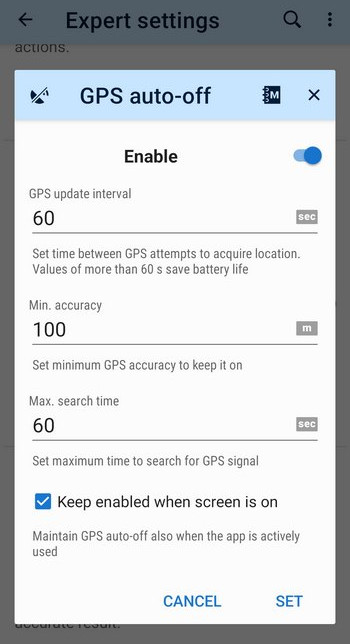
GPS auto-off is back
This feature, which made life easier and saved the battery for long-distance travelers and wanderers, had to go, as it didn’t work properly on many phones – a lethal combination of battery optimization and a number of system permissions for location access made it impossible to exist.
Fortunately, we’ve managed to discover a way to restore the feature so that it’s fully functional on Android 12+ phones. However, you still need to have Locus Map excluded from all battery optimization options (but Locus Map can’t do without that now anyway). If you don’t know how, this site will give you the details directly on your phone.
However, we’ve placed the option in the Expert settings section. Its use is really specific and has no justification for normal day trips.
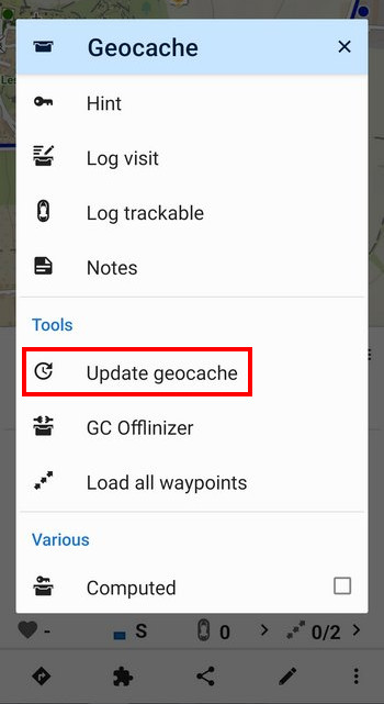
More improvements for geocachers
In the previous version of the app, we’ve made a lot of geocaching features available that were originally only accessible through the Geocaching4Locus add-on. However, experienced cachers immediately threw a few things at us that we had forgotten in the rush. We hereby apologize and add the missing options to the app:
- the ability to update a cache directly in its details
- filtering of owners’ caches
- filtering of unpublished caches
- badge for downloaded caches
And don’t worry, it’ll get to the labs one day too, we’re working on it!
So we wish you all a beautiful spring and a nice start to the new season with your favorite outdoor navigation!
Featured photo by Nathan Dumlao on Unsplash
androidfile systemgallerygeocachingGPSitinerarynavigationnew releasephotosroute planner


41 Comments
Sjebali ste aplikaciju. Toliko je sada dobra da je više neću koristiti. Vaš premijum član.
Možete li nam reći zbog čega mislite da aplikacija više nije upotrebljiva? Razvijamo ga prvenstveno na osnovu ideja i sugestija naših korisnika. I samo smo malo promijenili način na koji se koristi funkcija "Navigiraj do". Osim toga, postoje mnoga druga poboljšanja. Bit će nam drago čuti vaše mišljenje.
You screwed up the app. It's so good now that I won't be using it again. Your premium member.
could you please tell us what exactly makes you think the app is no longer usable? We are developing it primarily on the base of our users' ideas and suggestions. And we only slightly changed the way the "Navigate to" feature is used. Plus, there are many other improvements. We'll be happy to hear your opinion.
Für's Geocaching ist die App immer noch kompliziert. Schade!
Hi Bernd, could you please tell us what exactly is complicated for you? We are developing the app primarily on the base of our users' ideas and suggestions. We'll be happy to hear your opinion.
jedinny dovod preco ostanem na starej app (premium) je, ze v novej 4.x chcete subscribcie na pravidelnej baze. Mne ako uzivatelovi co to potrebuje 3-4x/mesiac sa to absolutne nevyplati. a free verzia strada jednu dolezitu funkciu pre mna. velka skoda!
Dobrý den,
aplikace Locus Map 4 je dostupná v základní verzi a dvou Premium variantách již tři roky. Pokud vám nevyhovuje za roční předplatné, můžete ji použít za měsíční poplatek nebo nebo za jednorázovou platbu na tři měsíce. Nebo můžete také využít starší aplikaci Locus Map Classic, kterou ale již dále nevyvíjíme, pouze ji udržujeme.
I'm sure they did it on purpose just to make you mad! Why don't you just explain what your criticism is instead of just venting your frustration?
Navigace závisí na mapách. Po zjištění, že mapy založené na OSM jsou v docela tragickém stavu jsem začal mapovat, nejvíce u nás na Vysočině. Je zatím asi rok práce, spousta hodin, ale těší mě, že se to někam posunulo.
Dobrý den, děkujeme, že přispíváte do OSM komunity.
Wenn man einmal das neue Konzept Navigation/Routenplaner verstanden und sich darauf eingelassen hat, erkennt man schnell die Vorteile. Vor allem das nun einfachere und vielseitigere Anpassen der Navigationsstrecke nach eigenen Wünschen. Mir gefällt das Update sehr gut!
Danke sehr!
Cuando soportar la aplicación imágenes de satélite ?? Quien campo en su sano juicio apagaría el GPS ??? Ya existen power bank ...
Hi Kteban, if you need satellite maps, turn them on in the map manager or content panel. As for the GPS auto-off option, it is useful for long-haul travelers, expeditions etc., who do not need a super accurate track record, only one trackpoint per half a kilometer or so.
¿De qué estás hablando, Kteban? Locus ya dispone de imágenes por satélite desde hace dos años.
Y nadie te obliga a utilizar la función auto-off del GPS. Es una opción.
Thanks for providing this Update and for the informative article!
Great, great, great 🥳🥳🥳
Thanks! :)
Ich liebe Locus. Ihr seid super!
Danke!
When will the app start working properly like it did before the last update?
Hi, if you have any problem with the app, please contact the support team at help.locusmap.eu and describe the issue thoroughly in detail. Thanks.
Best app ever! It is very friendly once you get used to it, it has a learning curve, but it is definitely worth taking the time to understand all the features.
Keep doing what you doing!!!
Thanks!
So, I love the functions of the Locus Map improvements.
One thing that I would like to see back, is the whole day plot of the weather forecast. So, if I look at the weather plot (temperature + rain) in the afternoon, I would like to see also the plot of this morning. So I can see if the worst part of a rain shower is already over or yet to come, what was the maximum temperature of today, etc.
I believe it was like that in an earlier version of Locus Map.
Hi Rolf,
thanks for your feedback. The weather forecast in Locus Map is provided by OpenWeather service which sends data only regarding the future.
when will there be integration with the bosch kiosk?
Hi, we've been trying to contact Bosch with an offer for partnership for a few years but so far, we haven't received any reply.
Hallo,
ich steige gerade von Classic 3 auf Version 4 um.
Es ist so, wie es immer ist. Jetzt kosten die Höhendaten.
Gleich werde ich überprüfen, ob die Höhendaten auch bei den schon bezahlten Karten, wo die Höhendaten kostenlos waren, betroffen sind.
Vielleicht ist ein Update der schon bezahlten Karten besser.
Bei den 3 kostenlosen Karten die man bekommt, sind die Höhendaten auf jeden Fall nicht mehr kostenlos.
Grüße
So, I'm back at Locus Classic3...
I won't pay extra for the altitude data, because that's only possible with a premium account.
Great trick, but not with me. There are alternatives.
cu Paul
Hi Paul, actually, you don't pay for the elevation data only. The subscription finances the maintenance, updates, support, third-party services (GraphHopper, Google address search, global satellite maps, weather forecast, storage services etc). We would go bankrupt if we stayed by the single payment apps.
Dobrý den,
pokud uložím trasu, tak po uložení se nezobrazuje profil trati. V modu úpravy trasy je profil vidět. Po uložení jsou vidět jen označení nejvyššího a nejnižšího bodu.
Ještě upřesnění. Aplikace se tak chová v MS Edge, Chromu i prohlížeči Brave.
Dobrý den, na odstranění problému pracujeme. Příště prosím hlaste chybu na našem Helpdesku na https://help.locusmap.eu. Děkujeme.
Hi. 3 Monate war ich mit Locus Classic in Spanien und Portugal unterwegs. Die App ist hervorragend. Nun habe ich zu Locus 4 gewechselt, plane eine neue Reise im Web Planer und habe 2 Verbesserungsvorschläge.
1. Die Ordner sollten einfacher zu leeren sein. Es kann doch nicht sein, daß ich jeden Wegpunkt einzeln löschen muss.
2. Ich nutze auch einen Garmin Edge. Warum muss die Übertragung der Daten so kompliziert sein? Eine kleine App in Garmins IQ Shop könnte helfen.
3. Es wäre schön, wenn man die Tracks farbig gestalten könnte.
Jedenfalls vielen Dank für die sehr guten Karten und das perfekte Routing.
Hi Manoli,
thanks you for your kind words. As for the web planner + library, it still has limited options compared to the app but it is being developed and improved. As for the Garmin - there is an add-on Locus Map for Garmin that works on many deices but not yet on the Edge. It'll be hopefully added soon.
I love your app. It makes complicated things relatively easy to do, it is neat, well maintained. I decided a few years ago that it is easy the price (it is not cheap) and I keep thinking that.
I would also be interested in a better integration with garmin edge, even if I got the impression that Garmin tries to keep all the data recorded with its products in its ecosystem.
Keep up.
Thank you Gabriele for your support and kind words. We'll go on trying to make the best outdoor navigation app :)
SUGESTÃO DE ATUALIZAÇÃO.
1- POSSIBILIDADE DE INSERIR MAIS CAMPOS DE ACORDO COM UMA TABELA DE EXCEL IMPORTADA OU ADICIONADA MANUALMENTE.
2-POSSIBILITAR ATUALIZAÇÃO APOS IMPORTAÇÃO DESTA TABELA/PASTA EM TEMPO REAL SENDO COMPARTILHADO PARA OUTRAS PESSOAS QUE TAMBÉM POSSAM ATUALIZAR EM TEMPO REAL.
3- POSSIBILITAR O USO ONLINE E OFFLINE, SENDO QUE AO OBTER ACESSO A INTERNET, REALIZAR ATUALIZAÇÃO IMEDIATA.
(MODELO DE APLICAÇÃO - MY MAPS DO GOOGLE)
Hi, please send your ideas to https://help.locusmap.app for other users to vote. When your ideas get enough support from others, we'll start thinking about their implementation.