Summer is heating everything up, and since we’re not big on lounging by the water, we escape the heat either by heading into the woods or hopping on our bikes. And that’s the perfect opportunity to test out our latest updates. We’ve once again improved the route graphs—you can now actively work with them right in the route details panel. We’re also opening up Locus Map to a wide range of e-bikes and community sensors. So come check out all the new features and see why it’s worth updating today.
Charts you can touch
Previously, you could only view the elevation profile on the route panel. Now you can interact with it without having to open the full-screen graph. Pinch to zoom in, scroll, and watch as the corresponding section is highlighted directly on the map. This way, you always know which part of the route you’re currently viewing. In addition, the blue dot on the elevation graph marks your current position on the route—which is useful, for example, for estimating how far you are from the next climb. Zooming is smoother, even with very long recordings and during pauses when you’ve stopped. You can zoom in to a level of 100 m or 1 minute, no matter how long the route is.
Need more space for the map? Pin the graph, and all other route details will be hidden. Unpin it and return to the full view.

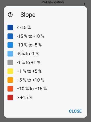
We’ve also redesigned the colors used to indicate route gradient. The gradient now ranges from blue for downhill sections (where darker shades indicate steeper descents) through gray for flat sections to a yellow-orange-red scale for uphill sections—both in the graph’s fill color and along the route line on the map. A new legend (question mark next to the route style preview) explains exactly what each color means for the currently displayed variable.
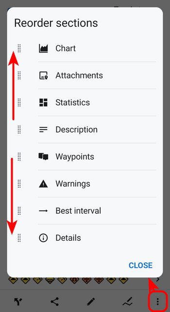
We’ve added an option to the Tools menu on the route details panel that lets you customize the panel to suit your needs—you can now decide the order of the individual sections (graph, statistics, waypoints, and more)..
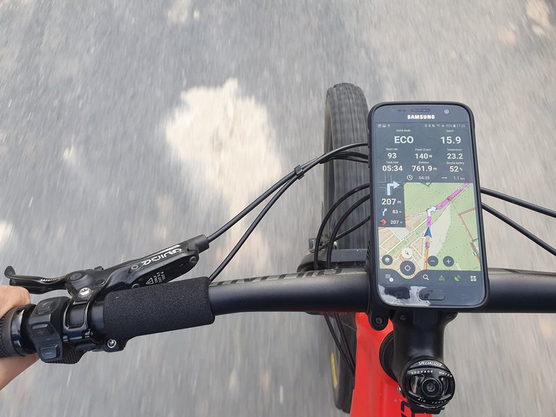
Data from your e-bike on the dashboard
We have significantly expanded our support for connecting external sensors via Bluetooth, this time to include a whole range of e-bikes: Bosch eBike Smart System (v19+), Shimano STEPS (EP-8, EP-801, E5000/E7000/E8000, EW-EN100), Fazua Ride 50/60. We’ve also expanded support for Specialized bikes across the TCX 2/3/4 generations. In addition to basic data on battery status, speed, and cadence, you’ll also get comprehensive telemetry wherever your bike provides it—motor power and temperature, battery status and number of charge cycles, remaining range, gradient, and current gear. You can also add gear and remaining range to your dashboard.
However, the connection is currently one-way: you can view data from the e-bike in Locus, but not the other way around. This means that navigation from Locus cannot yet be mirrored on the e-bike’s display. A deeper integration between the app and the e-bike’s firmware would require closer cooperation from the manufacturers.
It’s also important to note that this support is unofficial and has not yet been verified—we haven’t been able to test all combinations of models and firmware. That’s why we’d especially appreciate any feedback: you’ll help us continue to improve and fine-tune this support for as many bikes as possible.
Locus Map is also now open to community-developed sensor adapters. Third-party apps can integrate their own sensors—specialized BLE devices, protocols specific to certain e-bikes, and custom hardware—and real-time data from these sensors will appear in the sensor manager, on the dashboard, in the audio coach, and in the route recording. You can find the developer SDK at github.com/asamm/locus-api.
And that’s not all!
As usual, the new version, of course, offers much more. Among the most important features:
- IMG Maps for Garmin: We have completely rewritten the map renderer for the Garmin IMG format. If you use these maps, you can expect cleaner and more consistent rendering—and a solid foundation on which we will continue to build.
- Saving battery life: Guidance and navigation can now automatically pause once you stop moving, so a forgotten session won’t drain your phone’s battery.
- Calorie burn: Estimates are more accurate—terrain (uphill and downhill) is now taken into account, and the values are based on Compendium of Physical Activities 2024.
- Geocaching: You can restore and browse older logs; friends’ logs are grouped under the “Friends” tab; and Live Map now works on Android Auto as well.
So once the worst of the heat is over, head out into nature with the new version of Locus and let us know how you like it!
androiddashboarde-bikeElevation chartsensors


1 Comment
Ešte by sa pýtalo myslieť aj na užívateľov iných značiek hodiniek, ako Amazfit. Ale idete správnym smerom 👍