The new version of Locus Map brings a lot of improvements, fixes, and changes. We’ve chosen three of them for this short introduction. Two completely positive, and one, unfortunately, less positive, which you already met at the beginning of December last year:
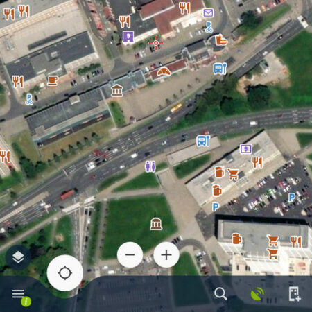
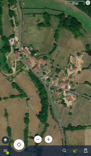
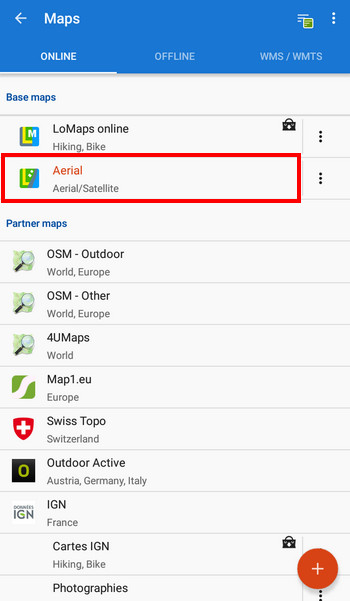
We have satellite maps of the world
Locus Map is one of the few navigation applications that are not built on the Google Maps API. This has significant advantages in terms of our creative and economic freedom, but also one major disadvantage – we cannot freely use Google’s map data. Unless we want a lot, and we pay a lot.
We, therefore, used to solve the demand for satellite and aerial maps with the help of regional suppliers. E.g. we offered USGS Ortophoto in the United States, in Austria satellite Basemap.at, in France IGN Photographies, etc. Unfortunately, most of the surrounding world remained without coverage.
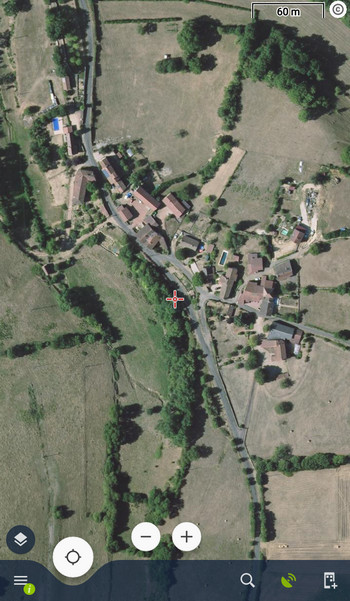
However, the situation has changed. Now, thanks to a more sustainable way of financing the application development and content, we have finally been able to afford to find a partner who has provided us with satellite and aerial maps with worldwide coverage at a reasonable price. These are current data from HERE, Maxar, and EuroGeographics.
Maps are available online in zooms down to level 18 and they can be kept in the Locus cache for up to a year.
In Locus, you can find the maps in the Online tab in the Map Manager. They are in a common category of base maps with our LoMaps and you can use them after purchasing the Premium Gold package.
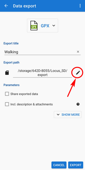
Export anywhere
The second positive news concerns the export of GPX, KMZ, TCX, etc. files.
In addition to the already known Dropbox, Google Drive, and OneDrive, you can save exported files from the application
anywhere on the device, including the SD card, even outside the private folder!
Data again only in private folders
And now we have the less positive news here. Unfortunately, after three months of rest, Google validators woke up from hibernation and revoked Locus Map 4’s “all files access” permission.
So what options does Locus Map have now?
Locus main directory
can only be:
- in the private directory in the internal storage
- in the private directory on the SD card
When you install the application, it creates its directory in the internal storage. It can then be moved to the SD card via the application settings.
If you have the main Locus directory /Locus/ in the root of the internal storage now, you’ll be prompted to start a smooth data transfer to the new location after the app update.
Where can I have maps?
You can have map files saved
- in the private directory in the internal storage – default setting after installation
- in the private directory on the SD card – this can be changed in the Locus settings, maps will be moved here, see >>
Plus, you can combine these
- with the Android/Media directory in the internal storage
- with the Android/Media directory on the SD card
Map files can only be saved in Media folders in the external file manager. Locus will load them automatically after reboot.
How do I get my own maps into the app?
When this plague struck us first in December 2021, all we could do was try it out with external file managers, a connection to a PC, and so on. Fortunately, we managed to deal with this – we have significantly improved the import of maps:
Import from map manager
- open the offline tab and under the “+” button you will find the item “Import”
- select source – device storage, Dropbox, Google Drive, OneDrive or remote file
- if you select the device storage, the system file manager will open and you can import the map into Locus from anywhere on the device. If it is a raster map, it will be saved in the Locus/Maps directory, if it is a vector, it will be in the Locus/MapsVector directory
Other imports
The map file is also recognized by the import started from the point or track manager. Everything then proceeds in the same way as in the case of import from the map manager.
Import from an external file manager
If you click on any supported map file in the system or external file manager, Locus Map will be offered as an application that can process the file. If it is a raster map, Locus will import it into the Locus / Maps directory, if it is a vector, it will import it into Locus / MapsVector.
What else can I have on the SD card besides offline maps?
- backup files – these can be stored on the SD card without any storage space restrictions
- online maps – definition and temporary files (cache)
- geocaching data – pictures, spoilers…
- SRTM data – offline elevation data, important for the elevation chart when planning routes, terrain shading, etc.
We hope that the last change did not upset you much. This is a limitation indeed, but you can still have your “big data” on the SD card and save space in the internal storage. However, we recommend using fast SD cards with the latest technologies – you’ll appreciate this when working with large map files.
exportnew releaseprivate folderSatellite mapsstorage


19 Comments
can you add correction module option for gcj02 & bd09 coordinates of Chinese maps which will only appear and take effect when Chinese language is selected? so as to facilitate the use of Chinese users, In this way, more Chinese will buy locusmap instead of using diy cracked versions for the correction
You can customise the used coords system, see https://docs.locusmap.app/doku.php?id=manual:advanced:customization:coord
The coordinate system of Autonavi map is GCJ-02, while the coordinate system of Baidu Map is BD-09 again migrated from GCJ-02. These coordinate systems are not included in EPSG, so Proj.4 library cannot be used for coordinate transformation.
Add this as an idea at help.locusmap.eu and wait if it gets support from other Locus users. When it gets enough votes we'll consider its implementation.
Dobry den,
Chcel by som sa spytat preco prestalo byt mozne otvarat Slovenske freemap v online mapach, chyba tam tlacidlo otvorenia, jedina otvoritelna je Ortofotomozaika SR, zaroven uplne chyba moznost outdoor od freemap, ktora tam este pred par dnami bola a je aktualne viditelna len na verzii 4.6.1.
Tento problem nastal na verzii Pro 3.58.1, aplikaciu som som preinstoval, premazal cache a nepomohlo mi to vyriesit tento problem.
Jedna sa o nejaky bug po update, alebo ake je aktualne riesenie na opatovne pouzivanie freemap SK map, hlavne outdoor pre verziu Pro 3.58.1?
Dakujem, Peter
Dobrý den, mapy Freemap jsou momentálně v procesu aktualizace. Některé vrstvy přestává poskytovatel podporovat, místo nich nasadíme novou. JE to otázka několika dní, prosíme o trpělivost, díky.
Dobry den Michal,
Dakujem za odpoved.
Dear Locus Team, glad to see You are still working to improve product not just leaving it dead - see that going gold was a good choice.
Thanks Paweł
Ve verzi Locus Map 4.7 při importu offline map dojede proces stahování do 50%, kde se na cca 4 sekundy zastaví a pak napíše "Proces neúspěšný" a v okně Oznámení je napsáno:
Chyba: T:Problem with validation of downloaded item
ReducedMedianFilter$IconCompatParcelizer, code: 12549
V předchozí verzi se nic takového nedělo. Je fakt, že jsem změnil hlavní adresář ze soukromé složky v interním úložišti na soukromou složku na SD kartě a pak i zpět. A také se mi už při první změně úložiště ztratily offline mapy, které jsem měl již stažené.
Díky Petr
Dobrý den, napište prosím na helpdesk https://help.locusmap.eu/ticket/add a uveďte adresu svého Locus účtu, podíváme se na to.
Vielen Dank für diese globale Satellitenkarte, die wirklich gut gelungen ist.
Ich hatte zuvor zwei Satellitenkarten von andern Anbietern über API-Key freigeschaltet, die aber durch ihr dunkles Erscheinungsbild für die Outdoor Navigation lange nicht so gut geeignet sind als die neue Locus Satellitenkarten.
Ich verwende die Satellitenkarten als Überlagerungskarte auf die LoMaps. Den Schalter für die Überlagerung habe ich in der rechten Menüleiste und bekomme so schnellen Zugang zum Transparenzregler. Dieser verbraucht leider ein Drittel des Smartphone Bildschirm.
Wenn ich mir was wünschen dürfte: Den Transparenzregler auf dem Kartenbildschirm, z.B. über das Dashboard zur Verfügung stellen. Oder gibt es dafür bereits eine Lösung die ich nicht kenne?
Macht weiter so, viele Grüße Gerhard
Hi Gerhard, no, this is not designed another way. If you have a wish, place it as an idea on help.locusmap.eu for other users to vote for it. When it gets enough support, we'll consider implementing it.
Dobrý den.
Jsem po mnoho let spokojeným uživatele Locus Map. Patří Vám veliká pochvala.
Pořídil jsem si nový telefon s Android 11. Chci importovat své staré trasy. Bohužel mohu vydrat vždy pouze jednu. Ve starém telefonu se starším androidem jsem mohl vybrat i všechny najednou. Jelikož si uchovávám mnoho zajímavých tras, je to časově náročné impotovat všechny trasy. Nejde to obejít, že bych trasy překopíroval do určitého adresáře? Jaké je jiné řešení?
Děkuji.
S pozdravem Standa.
Dobrý den, podržte prst na té jedné trase, objeví se zaškrtávátka i u ostatních.
Se puede usar el mapa satelital que nombran sin tener conección? Cómo se podía anteriormente con los de Google?
Hi, it is possible to cache the maps. The cached data are kept for a year in the temporary memory.
Really, what should we Farsi speakers do, everything is political, I'm sorry
Hi, Locus Map translations are provided by volunteers within a crowdsourcinng project Crowdin. The most agile translators are rewarded annually. Farsi translators haven't contacted us yet. If you speak good English, you can participate on the project and get Farsi into Locus Map, see https://docs.locusmap.app/doku.php?id=manual:about:translation.