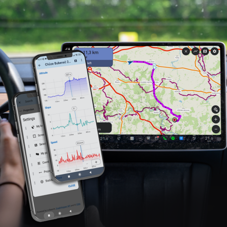

Even though the occasional rain outside doesn’t look all that inviting, spring is in full swing, so we’ve prepared a few more updates for the season. In the latest version 4.34, we’ve connected the main search screen with the location picker, further improved route charts, and added a few neat touches to Android Auto.
All-in-one search
There are many ways to search for a location in Locus Map. And the app has over 30 features that require you to define one! That’s why we’ve now connected the main search screen for places and online addresses with the picker for other ways to define a location. On a single screen, you can now search LoPoints, postal addresses, coordinates, a location saved to the clipboard, your current location, a spot on the map, custom presets, user points, projections, and so on.
The location picker is integrated into a horizontal sliding bar:
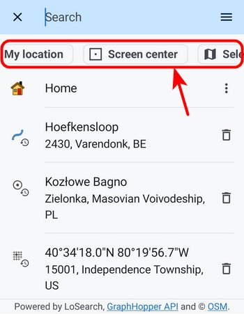
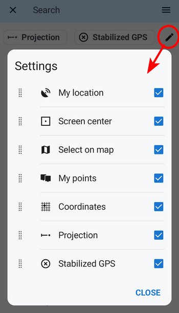
You can arrange the order of the buttons however you like:
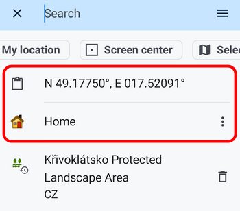
Clipboard contents and a predefined location appear right below the bar:
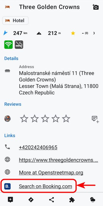
Search directly on Booking.com
For all points of interest related to accommodation, we’ve added the option to look them up on the global Booking.com portal. You’ll find the corresponding button in the details panel:
Charts communicate better with the map
The link between the chart and the route on the map has received another round of improvements:
- We’ve smoothed the charts, refined the time axis, and improved the visibility of the gradient chart.
- Via points now appear on the chart as well. Tap one to center and highlight that spot on the map.
- Tapping the route on the map shows the same point on the chart, and vice versa. By sliding your finger along the chart, you can animate movement along the route.
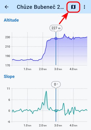
- On the detailed charts screen, we’ve added a button that displays the location selected on the chart on the map.
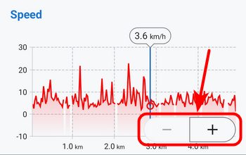
- You can zoom the charts not only with two fingers but also with zoom buttons, which you can activate from the screen menu:
Improved Android Auto
Using Locus Map in the car has been a huge hit, especially among off-roaders and geocachers, who need more than just roads and highway lanes on their in-car map. In today’s update, we’re bringing a few more tweaks that make the app easier to use for them.
Custom location definitions
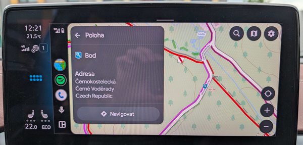
In Locus Map, you can define your own places that you want to navigate to repeatedly — whether it’s your home, work, cottage, or favorite trailhead. These locations are now available on the in-car screen as well.
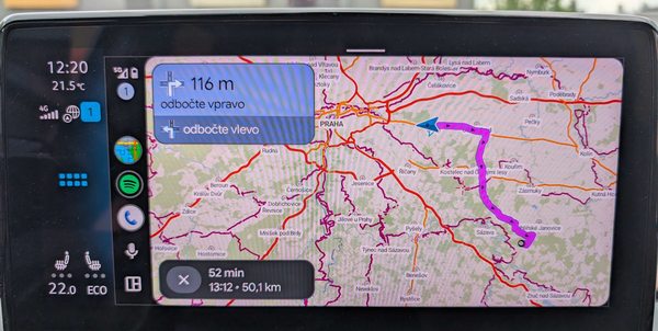
Full route preview
During active navigation, you now have the option to preview the entire route — on demand, the map zooms out and shows the complete route to your destination.
Little big improvements
Augmented reality
Locus Map was able to display points of interest through the camera in real time and space “before it was cool” — via the AR for Locus Map add-on. We hadn’t updated it for several years, so we’ve now integrated it directly into the main app.
- Highlight the selected category of points (LoPoints) above the map
- In the tools menu, tap “Augmented reality”
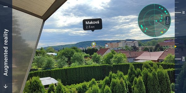
The feature will see further tuning so we can boldly stand up to our competitors :).
Control from the notification bar
Every Locus Map function that runs in the background — i.e., track recording, navigation, guidance, and live tracking — now has its own notification and STOP button. So there’s no need to open the app unnecessarily.
Full expert settings now available
Geek alert! If you want to have absolutely everything under control and love digging into the most hidden corners of Locus Map’s settings, we’ve made all expert parameters accessible directly in the app. Previously, they were only available through a special configuration file, config.cfg. We’ve now been able to ceremoniously retire it.
You can find out how to activate expert settings and what you’ll find inside here >>.
May is here in full swing, so get outside and try out all the new features! As always, you’ll find the complete list of changes and fixes in the news under the “About the app” section. And if something isn’t working as it should — or if there’s something you really like — let us know!
androidAndroid AutoElevation chartlocation pickernew releasesearch


23 Comments
I would prefer an update to the watch-app.
Yes, these features like Booking, Augmented reality sounds cool but nothing thats used very often I guess. Please prioritize an update to the wear-os app since it has a lot of room of improvements.
Hi Kenneth, thanks for the honest feedback — and you're right that our Wear OS app has been overdue for some attention. Good news: a major overhaul of the Locus Map Watch addon is on the way. It's something we're actively working on, and we'll share more details once things take shape. In the meantime, if there are specific improvements at the top of your wishlist, we'd love to hear them — that kind of input genuinely helps us prioritize. Cheers!
Not Kenneth, but would also be more than happy to have an update of the wear os watch app.
What I was missing the most was some kind of vibrating feedback on the watch for when I missed the original path and took the wrong lane while hiking. Or some vibrations, when one has to take a turn at a junction.
There were countless times, where i missed a junction because of a nice chat with my hiking partner (phone is in the pocket). It would also be a unique selling point at the moment, because as far as i know, no wear os map service has offline maps on the watch (via phone) and vibration notifications for turn signals / missed routes on the watch at the same time.
Bonus points (vibrations is more than fine on the watch) 1: if i would be able to play a custom sound file (so it is not an annoying beep ;) ). The speaker on e.g. the Samsung galaxy watch ultra became suprisingly good.
Bouns Points 2: It would be nice to be able to switch on/off the notifications for the turn signals and the missed route seperately.
Usecase: e.g. easy route: only missed route on
Complicated route: also turn signal notification on.
A feature I'd like to see in the WearOS app is the ability to have the current location set about 1/3 of the way up the screen so I can see more of the upcoming route, much like it is in the phone app.
Hi,
on Smartphone I like the option to have the straight line from position to the selected target.
In Android auto i can "only" activate the real navigation.
Is there a plan to the "target guadiance line" to Android Auto?
Martin
Hi Martin, when you start navigation with the guidance line to the target from Locus Map on your phone, you'll see it on the car screen too.
I use the augmented reality all the time, the AR updates are very welcome and overdue...to increase chances of change, lurk on the locus helpdesk and forums....
I haven’t tried it yet, but the extra / separate gradient display (“slope”) is brilliant!
They’ve finally addressed it, after it was pointed out several times.
Perhaps the slope display could be expanded further, for example when viewing a recorded route (so far, the slope can only be shown using different colours): perhaps by tapping a point on the recorded route to display a small slope reading directly on the map.
Jason
To mi na Locuse vzdy vadilo. Stratenemu a netechnickemu cloveku v horach na jednej ciarke signalu som musel 10 minut vysvetlovat, ako mi posle SOS suradnice svojej polohy. Take nieco zakladne musi user friendly zvlanut aj zamrznuty clovek, ktoremu uz odchadza mozog a je v totalnej paralizacnej krize :)
Dobrý den, pokud si zobrazujete souřadnice na horní liště, stačí na ní podržet prst a souřadnice máte zkopírované ve schránce. Odtud je můžete dostat kam chcete. Je to otázka sekundy.
I would love much more options to customize the track overview to share which friends or social media. More formats (9:16, 16:9, etc.), general design, complete authority which information I want to display and which not (total or effective time, avg speed incl or excl breaks, length, etc.), more map types, and so on. Current limited options are not suitable, which is kind of sad, as sharing also spreads the word about Locus Map in a subtle way. ;-)
Hi Stefan, what is the biggest disadvantage of the current solution for you? We're definitely planning to enhance the sharing options, based on our users' feedback.
Hi Michal. Biggest disadvantage? The absence of the things I listed above. ;-)
If I had to choose just one thing, it would be to not just choose with/without statistics, but exactly which ones.
By the way, the already available option to choose between map and own pictures is nice.
In the last release note, i posted the following. I saw that this bug is still present with 4.34.1, will this be fixed in a later version?
In the new chart design when I click at a certain point I see the y-value displayed, but not the x-value. So I have to zoom in to estimate e.g. the timestamp at a certain height. In the old design both values were shown. Maybe there is already a possibility to configure this? If not please consider this for future updates! Many thanks and all the best!
Hi Thomas, this happens when you use long track names. When the name breaks into two lines, the X axis is slid under the bottom toolbar. I've discussed this issue with the devs but so far, there is no solution to it.
Not sure if we mean the same thing :)
I tried it with a very short track name but the issue persists. I use android, just for information.
I escalated the issue to the devs because they're working on redesigning the whole bottom sheet at the moment. Perhaps this issue will be solved.
Thank you for your efforts! I really appreciate your cooperation! As the hiking season is now in full operation, I hope the bugfix will help me with my work soon ☺️
I would like to see the app working with my Amazfit Balance and Zepp.
Thanks for your great work!
Hi,
these devices use a proprietary operating system. Locus Map only cooperates with Wear OS and Garmin watches.
Thanks to all the team for your great work !
Hi Vincent, we thank you for your support! Enjoy!
Informasi yang dibutuhkan banyak orang. Bookmark dulu untuk dibaca ulang.