Sometime around this time, in 2021, we slowly began to release the first version of the new generation of your favorite outdoor navigation – Locus Map 4. After a year, we would like to offer you a small summary of what we have accomplished during that time. A lot has been done, mainly thanks to you and your support, both moral and financial.
Brand new app
Let’s start with what is most visible:
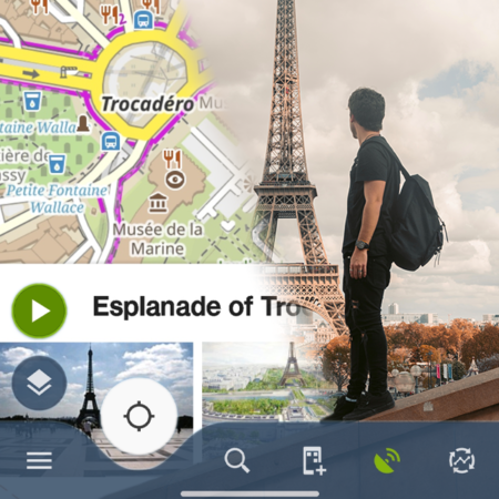
New user interface
- We clarified it, simplified it and adjusted it for one-handed operation. And both for right-handers and left-handers
- We added options for custom configuration of elements on the display – zoom buttons, map rotation and centering buttons, track recording, function panels – all of them can be combined for several variants of their visibility on the desktop
- The new content panel allows you to easily control everything you see on the map screen – maps and map themes, LoPoints, shading, photos…
- Routes and points got new slide-out panels with information and controls – all in one place, within easy reach of your thumb
- The new bottom-up main menu contains all the basic functions. Of course, it is fully configurable
- Last but not least, Locus can be switched to energy-saving dark mode, even automatically depending on the time of day
We’ve also added our own content and got rid of dependencies on external applications:
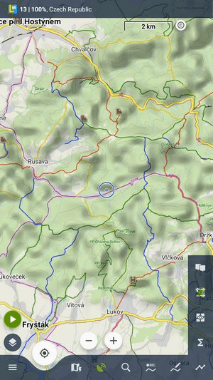
Our own maps, points of interest and router
- LoMaps – our tourist maps of the world are now available in a free online version for all users, not only in the application, but also on our new web route planner
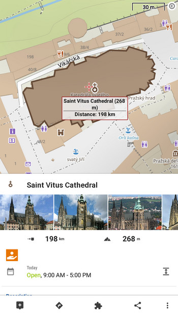
- LoPoints – these dynamic points on the map, describing civic amenities or natural attractions are now available online and offline. In the online version, we managed to enrich LoPoints with information and photos from Wikipedia, and we improved their search on the web.
- LoRouter – our own route calculation machine for planning and navigating to a destination. It is available online in the application and on the web, as well as in the offline version for the most demanding outdoor fans.
Synchronize the application with the cloud, the web planner and across multiple devices
Locus Map has always been a purely mobile application with no server background. There was a radical change a year ago – you can now sync routes and points automatically:
- From mobile to cloud and back – you no longer have to worry about data if your mobile is lost or damaged
- From the cloud to the web library and route planner – what you plan on the web is right on your mobile and vice versa
- Among several devices – do you have a mobile phone and a tablet with Locus? You record the route on your mobile phone, save it and you have it on your tablet right after. The number of devices connected in this way is not limited.
Over the year you’ve synchronized over 1 million tracks and routes.
Brand new web planner and route library
We used to think that planning a route right on your mobile phone was enough. And we did our best for that and developed the route planner in Locus to the best of its kind on the market. But the big PC screen just makes sense for planning trips and entire vacations. And so we developed a web-based planner with an associated library of users’ tracks and points.
- You plan the route on the web then you go on a trip with Locus on your mobile phone
- You can record the expedition in the mountains with the help of Locus, at home on the couch you can see the route on the big screen of your laptop
We are constantly working on the web planner and library. A lot of improvements await you this year.
It wouldn’t be possible without you
Web services, synchronization, cloud, servers, storage, user support, continuous development – it all costs a lot of money. But thanks to you, we manage to get it all running. We are sure that the new subscription financing system really works to your and our satisfaction.
If you continue to support us in this way, we plan a lot of other great things:
What awaits you
- further development of the application – improved search, new dashboard, satellite maps of the whole world (finally!!)
- web planner and library – import of routes, other maps from other providers, more detailed graphs
- more app purchase options – we’ll introduce also one-time period purchases with no auto-renewal


15 Comments
Hallo,
Ich habe gerade leider Locus Gold gekündigt. Vor ein paar Monaten wollte die App keine Höhendaten runterladen und forderte mich auf, Silber oder Gold zu kaufen. Das Problem hatte sich dann irgendwann erledigt. Seit ein paar Wochen funktioniert das Routing nicht mehr. Vor ca. 4 Wochen: ich war mit dem Fahrrad immer ca. 700m weiter als der Corser in derApp und die Anweisungen. Zuletzt vor 1Woche war noch gleiches Verhalten der App zu sehen. Diesmal in einer freunden Umgebung konnte ich mit der App gar nicht fahren.
Ich habe noch die alte Proversion, die hat jedes Mal gut funktioniert.
Vielleicht probiere ich es ja irgendwann nochmal. Wenn Ihr die App dann verlässlicher bekommen habt würde ich mich freuen.
MfG
Günter Schilkowsky
Hi Günter,
all the issues probably originate from the wrong app setup. All these are basic features that are the same in Locus Map 4 and Locus Map Pro. If you have any problem, tell us about it, we'll do everything to help. More at help.locusmap.eu.
Hopefully you will convince Huawei not to blacklist your app for killing in the battery save mode by Power Genie. Come on, guys, something has to be done finally. Put more pressure on Huawei to let Locus work in power save mode.
Hi Ernest,
do you really think that we have any influence on Huawei's decisions? No, we really don't.
Hey,
I just moved to iphone and realized that its not possible to use Locus Map. One of the best apps for offroad navigation and it is quite sad that i might not be able to use it again. Is there any plans to bring app on iOS?
Yes, there are plans... but just plans, so far. A long way to go before any of our apps hits the Appstore.
Hallo, ich arbeite und navigiere seit vielen Jahren mit Locus Map Pro. Kann ich mit dem damaligen Erwerb von Locus Map pro auch die neue Version Locus Map 4,4 in vollem Umfang nutzen? Wenn ja, was muß ich dafür tun.
Hi Jörg,
Locus Map Pro and Locus Map 4 are two independent projects, two independent apps. Locus Map 4 originates in the former Locus Map Free - it is available in a basic free version and two Premium versions - Silver and Gold. At the moment the Premium can be subscribed monthly and annually. As a Locus Map Pro owner you can get one year of Silver for 100% free and one year of Gold for 50% discount. More at www.locusmap.app/premium.
Danke für die schnelle Antwort Antwort.
Love all the hard work you do , plus excellent customer communications.
No už jsem vás dlouho nepodpořil, ale chystám se, a to především proto, abych měl vymoženosti, které mám zakoupené ve 3 i ve 4. Reaguji ještě na vaší zmínku o web plánovači- skvělá věc, ano, dělat plán trasy na obrazovce je něco jiného než v mobilu, ale právě na webu bych uvítal možnost, kterou mám v aplikaci- rozlišit barvami nadmořskou výšku. Používám při plánování cyklotras- radši si pár set metrů nebo i kilometrů zajedu po horších cestách, než mít "ztracený spád", jak my traséři v dopravních stavbách říkáme, čili zbytečně někam sklesat, abych to musel později zase vystoupat, raději po vrstevnici anebo při konstantním mírnějším sklonu. To se ale dostávám k dalšímu možnému vylepšení- podrobnosti polních a lesních cest v Lomapách, někdy postačují, ale někdy musím konstatovat, že u konkurence jsou podrobnější. Někdy si vypomůžu mapami z katastru 1:10000, tam je to ještě podrobnější, ale to přepínání map mne taky moc nebaví, neřku-li, že v plánování trasy musím nastavit úsek "nakreslit" namísto třeba MTB. To už jsem ale v B routeru..., ten snad ve 4 odpadá. Zdravím
Dobrý den, barvení linie podle stoupání ve webovém plánovači je hudba budoucnosti, ale věříme, že se k tomu dostaneme. Co se týče podrobnosti LoMapy - je přesně taková, jaká je místní komunita OSM mapařů (přispěvatelů do projektu OpenStreetMap.org, z jejichž dat se mapy generují). Tzn. někde je mapa podrobná (zejména v okolí větších měst), někde již méně. Mapařem OSM se může stát kdokoli, a přispět tak k podrobnosti a přesnosti (nejen) LoMap - viz https://learnosm.org/cs/beginner/.
ještě doplnění - barvení linie trasy podle sklonu dostatečně supluje synchronizace kurzoru na linii a v grafu - na mapě vidíte, kde na trase se nacházíte a na grafu jak hodně trasa stoupá (lze nastavit jak absolutní nadm. výšku, tak sklon v %). K tomu plánování - router také čerpá z OSM dat, a to jak náš LoRouter, tak BRouter (lze jej v LM4 také používat). Takže pokud na mapě chybí cesta, lze ji na trase "dokreslit".
Díky za odpovědi, barvení linie trasy je taky skvělá věc, pro kterou Locus používám. Když už jsme u toho: existuje nějaká možnost mít obarvenou trasu i při prohlížení vytvořených tras anebo dokonce přímo v navigaci?- abych při reálné jízdě v terénu viděl, co mě v nejbližší době čeká a nemusel přepínat na trasování nebo podélňák.
"Rozlišením barvami nadmořskou výšku" jsem ale měl na mysli barvení přímo podkladových map, ve kterých trasuji. Konkrétně volbu nastavení- mapy- pokročilé funkce- stínování mapy- barvy podle nadmořské výšky. Používám i na vrchovině (Česká Sibiř) možnost Nížina, protože tam mi to připadá nejlogičtější. Konkrétně používám tak, že si nejdříve nechám trasu spočítat plánovačem, pak si prohlédnu podélný profil a tipuji, kde je zbytečný ztracený spád a teprve pak určitý úsek nebo i celou trasu přeplánuji.
Taky díky za připomenutí o tom, kde mají Lomapy svůj původ- ohledně polních a lesních cest. Pro náhodné čtenáře bych snad jen upozornil, že jejich používání není bez rizika a že umístění trasy na ně může vést ke zklamání: co ušetřím na spádu, ztratím tím, že se budu muset odněkud vracet, protože např.:
- pasák dobytka cestu přehradil ohradníkem a pokud podlezu riskuji napadení rozzuřeným býkem nebo jalovicí (stalo se mi na oficiální stezce KČT)
- starosta příslušné obce prodal cestu nějakému souhromému majiteli a ten ji znepřístupnil či dokonce si ji ohradil, což v mapách ještě není zaneseno
- lesáci při těžbě cestu totálně zdevastovali, že není schůdná ani pěšky, natož na kole
- nadšení ochranáři upozorňují cedulemi, že v lokalitě vysadili vlky a pokud tam jedu, riskuji napadení
- cesta je neudržovaná a zarostlá protože po ní nikdo několik let nejel
Na druhé straně existuje někdy příjemné překvapení, že oficiální cesta má souběžně neoficiální po louce, která je pohodlnější a jsou v ní znatelné vyjeté koleje. Výhodné ale až po první senoseči, (konec června), ještě lépe po druhé (konec srpna- září).
Dobrý den, ano, linie podle úhlu stoupání/nadmořské výšky či dalších proměnlivých parametrů lze barvit i jinde než v plánovači, viz https://docs.locusmap.app/doku.php?id=manual:user_guide:tracks:management#track_route_style. Barvení podkladových map podle nadmořské výšky je dostupné v aplikaci, na web s tím nepočítáme.