Winter is in full swing outside our windows in the northern hemisphere, we’ve swapped our bikes and trekking boots for skis and snowshoes, and we’ve switched LoMap to a winter theme in Locus. But our blog isn’t here for some general chatter. Let’s recap the pile of news that November and December brought.
New start
Literally! The new version of Locus Map has a completely redesigned launch and boot-up of the application. It’s much faster, as a lot of settings and your data are loaded in the background. It’s also smoother and prettier thanks to a nice opening animation (hello to our graphic designer Zdenda).
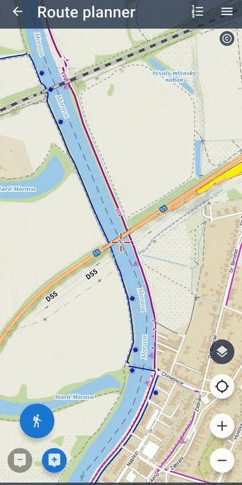
The route planner, continued
We’re still tuning the route planner for you because we want to have the best one in the world. We want it to come up with exactly the routes you need. And what’s new now?
A new selection of routing profiles
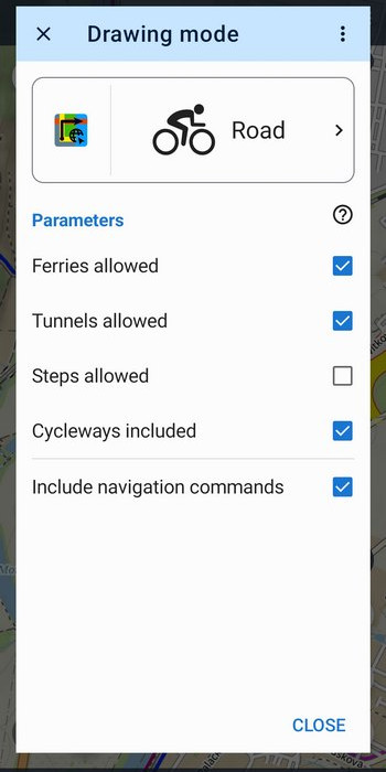
A little heads-up – the route planner uses a little machine we call a router to automatically draw routes along paths and trails. This offers a number of settings depending on the type of activity on the route – and these are profiles. For example, the “hiking” profile will generate a route along paths and hiking trails. Well, since the number of profiles and their parameters is growing in our LoRouter, we had to rework their selection. We simply couldn’t fit them into the original solution anymore.
This new feature does not yet apply to the activity selection for the “Navigate to” – direct navigation to a specified destination. On the contrary, we have now simplified it a bit, as a big change is coming. But let’s not get ahead of ourselves just yet.
All for better cycling routes
We have added additional parameters to all cycling profiles that affect route generation. So you can turn on and off tunnels, cycle paths, ferries or stairs, depending on what bike you’re riding and what you’re up to. And, there are the five levels of terrain difficulty for mountain bikes we wrote about last time. If you have a tip for another useful customization, post it in the comments, we’d be happy to consider it.
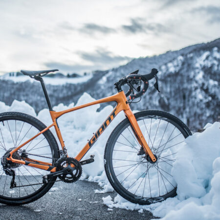
Gravel versus touring
The much-loved gravel has now been added to the group of bike profiles. With this profile, the LoRouter will push you harder on gravel and firm forest roads and is not afraid of hills. We’ve toned down the original touring a bit so that it plans trips more on bike paths and doesn’t bother you as much with climbing.

Online or offline, still the same LoRouter
Thanks to configuration sharing, both versions of our router now offer the same profiles and their parameters. So with or without the internet, you have the same planning options. Soon we will see this option in the web planner as well.
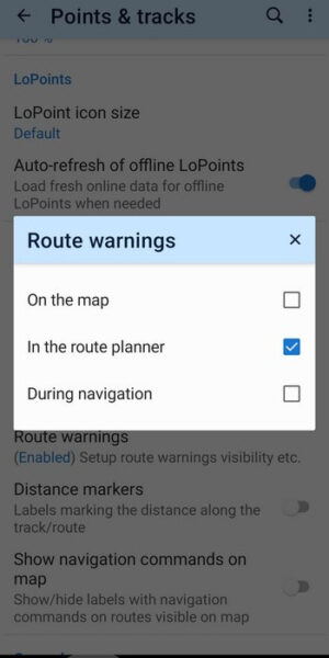
If you’re adventurous, you’re properly adventurous
In the previous version of Locus Map, we introduced displaying warnings about various pitfalls on the route – unprotected crossings, difficult terrain, barriers, etc. However, the more adventurous among you immediately said they’d rather enjoy the ride with all the risks. And so we’ve accommodated them – you can turn off the warnings centrally in the settings, at three levels – on the map, in the planner and when navigating.
And lots of minor improvements
- Something for the geocachers – we continue to add features directly into Locus Map so that they are available without the need to download the Geocaching4Locus add-on. We’re adding cache search by GC code (don’t worry, the Live Map is in the works).
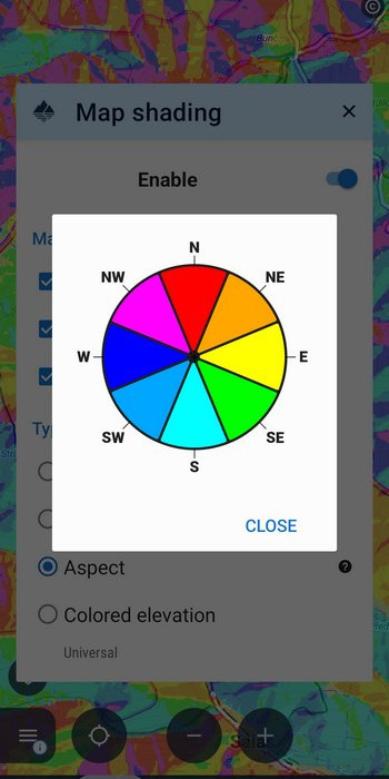
- Aspect shading – something for those hunting for beautiful sunrise or sunset shots
- the ability to display the dashboard as a separate screen – appreciated by technical types who are bothered by the numbers above the map and want to have them nicely visible extra. This option can also save battery significantly, as the map is not redrawn below the dashboard during activity.
Refreshed Locus Map Watch
We’ve resuscitated the popular Wear OS smartwatch add-on so it meets the latest standards and works on the most advanced devices. Furthermore, we’ve improved its UI and added a dark mode to save battery.

So head out for a snow adventure, the conditions are excellent!
Photos by Locus Map, Alessio Soggetti and Dmitrii Vaccinium on Unsplash
androidcustomizationgravelLocus Map WatchLoRouterrouter


38 Comments
Ótimas notícias, excelentes melhoramentos... parabéns.
Skvělá práce
co třeba plánování trasy s terénním kočárkem. Díky za skvělou práci
When do you plan to incude water ways route planning for the kayakers paddlers? Like e.g. the caua app?
Would appreciate a pretty huge amount of water spirt enthusiasts?
Yes, there are plenty of us who spend time on the rivers and lakes who would love to be able to plan routes and select destinations. At the moment I use Locus for recording my tracks but cannot plan trips or use waypoints which are on water only. The biggest advantage has been the ability to follow a navigable river channel during severe flooding, when banks are submerged and the river has become a lake.
Would be great if instead of creating empty headlines for changing BackgroundColor=white to BackgroundColor=black you would actually fix the bugs the locusmap watch app has.
Hi Finn, we don't remember whether you reported any LM Watch bugs on our helpdesk. Did you do so? Which bugs were they?
Thanks to all your help, I finally converted to Locus 4 and got it up and running on my new Pixel 7a. Love it!
The route planner tickboxes idea for cyclists could also help walkers. Your planner avoids main roads like the plague for walkers, sending you way off route. But a short stretch of main road often has a pavement and is fine on a walk. I would like to allow main roads and control that myself, personally.
Such a good idea. But also the other way around, when you prefer to take a shortcut by walking your bike along the sidewalk instead of pedaling kilometers around. And it would be good if the planner showed and warned about places such as for ex. stairs.
Hi Mark, yes, routing for walkers is opinionated. But main roads with (mapped) sidewalks should be avoided less than plague. If you have a few examples in mind, please show us these here please https://help.locusmap.eu/ticket/add
Plánování trasy s terénním kočárkem by se mi také líbilo, ale nevím, jestli je to reálné. Nastavení parametrů věřím, že bude obtížné, navíc třeba na Mapách.cz (i na Locusových) ne každá stejně zakreslená cesta je ve skutečnosti stejné kvality. Ale i kdyby se objevily chyby, uvítal bych tuto možnost (s manželkou někdy holt kočárek nesem v rukách, když se naskytne kratší nesjízdný úsek).
When drawing routes it is very frustrating that if there are marked a block or barrier (X) on the map it is possible only draw by hand.
It would be nice option to choose that you can ignore this blocking by software and draw automatically even if there are barriers on the route.
Because here in Finland we are allowed pass through the barriers and move on private roads as long as road won't lead to someones home yard, businesses, authoritative or military areas.
Hello iLari. If you show us some wrong examples here https://help.locusmap.eu/ticket/add we will appreciate that.
Well done... Can you also redo the Garmin add-on pleade so that the map and other feature work correctly (other garmin app can display maps from the phone one the watch without problem, dwmap etc). I need the data to be on on my phone as. I use live tracking on long hike etc...
Very useful updates also in this new version, thank you.
For the router tool I'd highly recommend to enrich the gravel bike category with similar five difficulty options like you did it for the mountain bike category. But in fact not focused only on the slope but mainly on the quality of the roads. As with the Gravel E-Bike you don't have the problems as in the past, so the focus is no more on slopes.
And for all bike categories I would love to have an option where I could say "avoid roads" in three steps.
For completing my wish list I'd also like to have an option "prefer bicycle routes" in three steps.
So with that everyone could adjust and find an optimized new route for himself by recalculating the route in planning mode.
At last the subscription to silver and gold could be improved, mainly for map availability. I always prefer a one time payment instead monthly rates, using this app without subscription to silver is nearly unuseful as major functions are missing in the free version, like rerouting when changing bike category or options there.
But over all you're on the right track!
Thanks and watching your next version.
Die zusätzlichen Optionen sind sehr nützlich, vor allem für Neulinge. Bis zum Update verwendete ich immer die Brouter Profile, auch im LoRouter Offline.
Vor allem diese Profile wären für mich ein großer Verlust der Qualität von LOCUS.
shortest, rail, river, Trekking-FCR-dry, trekking-ignore-cr, Hiking-Mountain-SAC3, Hiking-Alpin-SAC4...
Darum möchete ich Bitten die Möglichkeit der Verwendung der Brouter Profile wieder herzustellen
Vielen Dank
Bin schon gespannt auf die nächten Versionen
Hello Alex, it is still possible to use external profiles originated from Brouter project. You just have to re-import them, unfortunately.
Hallo Radim, wie macht man den Re-Import? Ich habe die brf-files in das Verzeichnis "Android\data\menion.android.locus\files\Locus\router" kopiert, aber ich kann sie keinem Profil zuweisen, egal ob ich BRouter oder LoRouter ausgewählt habe. Es erscheint allerdings auch ein Hinweis, rot unterlegt: "Zusätzliche Routing Parameter für 'Navigate to' wurden vorübergehend entfernt...". Gruss, Manfred
"Android\data\menion.android.locus\files\Locus\router\profiles2" war gemeint
Hi Manfred, here's how to edit and add profiles for BRouter: https://docs.locusmap.app/doku.php?id=manual:faq:how_to_navigate_offline#brouter. "Navigate to" is now in "deprecated" mode and does not contain the new routing options. Use only the route planner when you want all BRouter features. The "Navigate to" will be soon integrated with the route planner.
Hallo Michal,
diese Hilfeseite hatte ich bereits gefunden, aber ich weiß nicht, wie ich zu dem Dialog mit der Überschrift "BRouter" komme, auf dem sich die Profile befinden. Ich finde etwas Ähnliches nur bei "Navigation", aber wenn ich dort lange auf ein Profil drücke, erscheint nichts, obwohl sich laut Hilfe eine Auswahl Edit/Delete öffnen sollte.
Ansonsten kann ich mich nur Alex anschließen, die BRouter-Profile sind ausgezeichnet und es wäre ein großer Verlust, wenn es die nicht mehr gibt. Am besten wäre es, wenn ihr die Parameter von BRouter weitgehend übernehmt, wie z.B. stick_to_cycleroutes, allow_steps, avoid_path, avoid_unsafe.
Gruss, Manfred
Hi Manfred, BRouter profilesd can be edited in the Locus Map's route planner > drawing mode button > BRouter (left part of the main profile section button). The parameters "stick_to_cycleroutes, allow_steps" etc. have already been adopted by LoRouter.
YuHu!!!
Locus Map 4 Gold ist gerettet. Danke für ihre Infos. Habe etwas gebraucht bis ich gefunden habe (Routenplaner) wie man die Profile (shortest, rail, river, Trekking-FCR-dry, trekking-ignore-cr, Hiking-Mountain-SAC3, Hiking-Alpin-SAC4...) einstellen kann.
Wollte schon auf Locus 3 zurückkehren.
Hut ab für eure tolle Entwicklung
I suggest a profile for electric bicycles, that is pedelecs, where maximum sustained help is 250W.
Je teste locus Map, après avoir téléchargé un tracé dans locus Map,le suivi pose problème :l'application créé des entités tracés et bip en permanence pour signaler hors parcours,pourquoi locus ne suit pas correctement la trace, merci de me renseigner.alain
Hi, please contact us at helpdesk help.locusmap.eu and send a detailed description of the actions leading to the error and screenshots. Thanks
Hallo Michal,
vielen Dank für die Antworten. Ich hatte mein "Problem" inzwischen gelöst, indem ich BRouter-Profile für LoRouter passend machte und Parameter, die LoRouter nicht verarbeiten kann ("consider...") auskommentiert habe. Dass man mit einem Klick auf "left part of the main profile section button" schnell von LoRouter zu BRouter wechseln kann, war mir allerdings nicht bekannt. Die beiden Profile fürs Radfahren "Schnell" und "Radreise", die bei BRouter als Standard angeboten werden, solltet ihr vielleicht um ein weiteres ergänzen (Vorschlag "Trekking") und diesem ein Profil wie "Fastbike" zuordnen, bei dem man dann auch tatsächlich Parameter wie "Stufen erlaubt", "Fähren erlaubt", "Autobahnen eingeschlossen", "Radwege ignorieren" und "Radwege bevorzugen" angezeigt bekommt. Ich hätte mich schneller einarbeiten können, wenn unter "Radfahren" ein Profil vorhanden wäre, bei dem ALLE verfügbaren Parameter angezeigt werden.
Was mir auch noch auffiel: Ich kann BRouter nur nutzen, wenn die Routingdaten zusätzlich auch im "btools"-Verzeichnis der BRouter-App vorhanden sind. War es früher nicht so, dass sie NUR im menion.android.locus-Verzeichnis liegen mussten und sowohl von BRouter als auch von LoRouter verwendet wurden?
Gruß, Manfred
Hi Manfred, BRouter and LoRouter routing data have alwas been stored in different directories. BRouter is an external app so its data must be stored in its directory. BRouter is now fully customizable so you can use any of the profiles available in its repository, just copy them to /Locus/router/profiles2 folder.
plánovač trás je jedna veľká tragédia
Dobrý den, mohl byste prosím rozvést, proč si to myslíte? Týká se to webového plánovače nebo plánovače v aplikaci? Co konkrétně vám činí potíže? Díky předem za odpověď.
plánovača v aplikácii.
A co konkrétně je na něm špatně? Rádi se poučíme, abychom mohli aplikaci nadále zlepšovat.
Hallo and a good new year!
About 1 year ago you wrote: "wir werden höchstwahrscheinlich die Verfügbarkeit von Locus erweitern… Fanfare und Trommelwirbel… sogar für Fans der Apfelindustrie! Ja, wir werden wahrscheinlich schon im Frühjahr damit beginnen, die ersten (leichtgewichtigen) Versionen auf der iOS-Plattform zu testen."
May I ask what's the status?
Greets
Hi, we've been testing the first lite version. If you are interested, you can join the testing. More at https://help.locusmap.eu/topic/32424-locus-map-lite-ios-beta-program-open-for-new-testers.
Hallo ich benutze Locus Maps 4 Gold Edition auf einem Huawei P30 pro
mit Android (EMUI 12.0.0.219). Nun zum Problem seid dem Update auf 4.2 stürzt Locus Maps immer wieder ab. Das ist besonders unangenehm wenn es Mitten in der Navigation oder beim geocachen der Fall ist da es auch in ganz kurzen Abständen immer wieder der Fall ist. Ich hoffe das jemand eine Lösung hat. Übrigens die Berechtigungen im System (Standort und Speicher) sind in vollem Umfang erteilt.
Hi, we are sorry for any inconvenience. Please, contact our support team at https://help.locusmap.eu/ticket/add and tell us more, send screenshots and a bugreport (more at https://docs.locusmap.eu/doku.php?id=manual:faq:issue_reporting). We'll do our best to help.
Could you elaborate battery usage when dashboard is displayed on top of map? I'm using it in Classic.
Hi, battery level and battery temperature are among the available parameters for the dashboard.