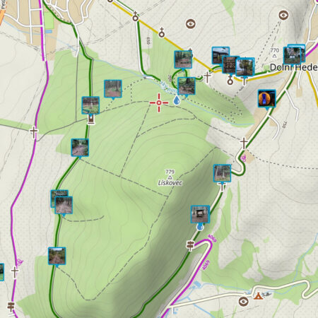
The smartphone age brings with it one major phenomenon – we all take pictures of everything, especially when we go on a trip or vacation. We bring back hundreds of photos from our holidays, and often we don’t even know where we took them. Locus Map offers a helping hand in this case too – it displays our photos on a map. The smartphone camera “geotags” each photo – that is, it “stamps” it with GPS coordinates (unless you tell it not to). And displaying anything with GPS coordinates above the map is a breeze for Locus Map.

Where do I get those photos?
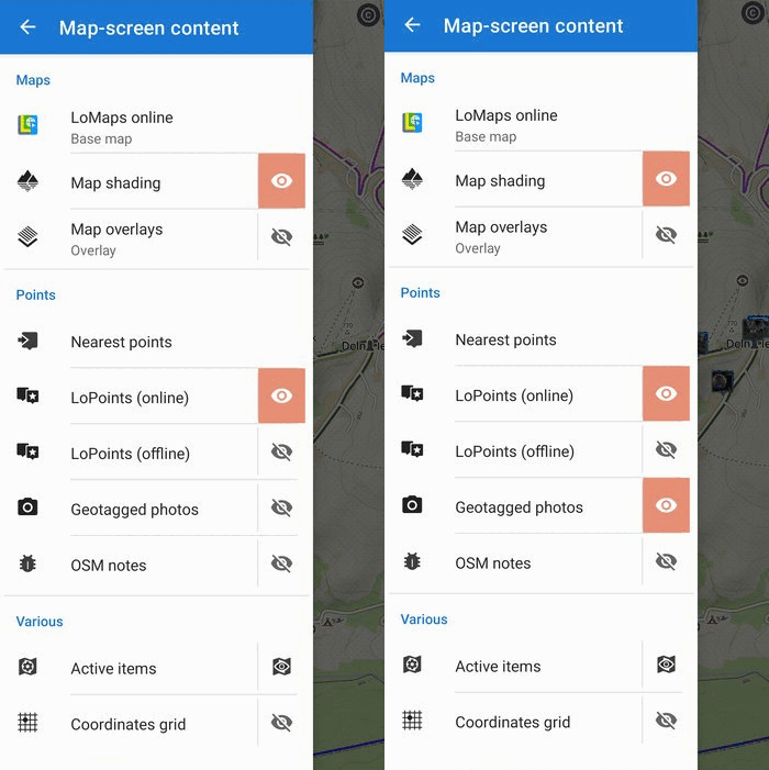
In order for Locus to display your travel photos above the map, you need to tell it where to find them. All this is controlled from the content panel on the left, the “Geotagged photos” item. The part with the label opens the selection of folders with photos, and the button with the eyelet turns on the display of photos above the map.

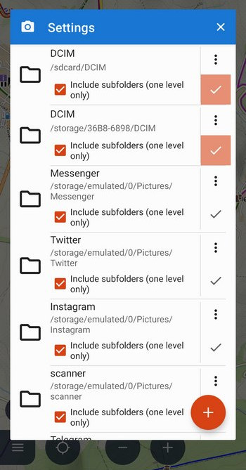
Let’s start with the selection of folders with photos. Tap the camera icon to open a window with all available photo folders on your phone, sorted by apps:

Check the ones whose content you want to display on the map. This is usually the DCIM folder, which is located both in the internal storage and on the SD card. Locus can also display one level of subfolders.
On older Androids (version 10 and below), you can also add your own directory from anywhere in your phone’s storage – tap the + button.
Quickly show, quickly hide
This is what the aforementioned, well-known eyelet is for:

Many of us have hundreds or thousands of photos on our mobile phones and Locus loads them gradually. Once there are too many on the map, the system can no longer catch up. We, therefore, recommend displaying photos in folders or turning them off when we no longer need them. Locus then responds much faster.
Show detail
The map with thumbnails looks cool, but what if you want to see the detail of the photo? Just click on a thumbnail and a panel pops up with distance, elevation, and other info and a larger preview of the photo:

Click on the preview to get to the detail, which you can enlarge with two fingers to the original size:

You can navigate, guide, and plan a route from your photos
The photos above the map behave exactly like normal points in Locus. You can start navigating to them, guiding to them with a beeline, or including them in the route when planning a trip:

It’s up to your imagination now. So get on your bike and go!
geotaggedgeotagged photophotosphotos on the map


19 Comments
Great feature, thanks!
Great ! Was uploading them manually point by point until now after my hiking/running/ATV trips.
But I can't manage to create a folder and copy my pics in it, geotags are lost after copy.
A lovely feature... Now since you bring it up. A feature for navigating to prev/next image if in fullscreen would be nice.
Also an image view without the huge title bar.
"Get on your bike". No, pls don't forget the hikers amongst us.
How about extending the feature with an option to source the photos from Google Photos cloud repository? That would make this perfect! Looking forward ;)
Only a few photos was shown. What can I make to see all pictures?
...and so runners and ATVs !
I managed to copy pics to a folder without losing the geotag, but half part of photos in the folder are not displayed, shame.
Please install latest 3.47.2. If the problem remains, contact our support at help.locusmap.eu. Thanks!
Незнаю как у вас у меня отображаются все фотографии
Zdravím Luxus používam dosť často aj ako záchranár. Chcel by som sa opýtať, že či sa dá poslať fotka a ten čo ju dostane si ju stiahne na mapu ako bod a môže spúšť navigáciu na danú fotku ako na daný bod? Ďakujem Slavo
Dobrý den, ano, na fotku lze navigovat, stačí ji zobrazit.
Same problem as Blntasca. Four pictures taken, only two are visible. Motorola Moto G6 with Android 9, Locus latest version
We've investigated this problem earlier. For some unknown reason some photos have incorrect EXIF and Locus can't read the metainformation in it. Sorry about that.
Locus is really the best!!!
Looks good ☺️
Hello, the handling worked very well on my smartphone, but impossible on my huawei tablet mediapad m3 where i have copied my pictures???
Thank's for your job.
Hi, please contact our support at https://help.locusmap.eu/ticket/add and send more info, screenshots etc.
Dobrý den. Locus je báječný. Rád ho používám. Nějak se mi ale nedaří fotky na mapě zobrazit. Měl jsem vypnuty služby lokace. Službu jsem zapnul, udělal fotku, nastavil cestu, ale fotku na mapě nevidím. Fotka údaje o poloze už má. Myslím gps.
Dobrý den, kontaktujte nás prosím na https://help.locusmap.eu/ticket/add a pošlete některou z problémových fotek k otestování. Díky. Michal, Locus team