Although summer is primarily a time for holidays, which we of course also indulged in, we have not slacked off in developing and further pushing the app for the better:
- We have unified the online and offline search for points of interest
- We have made working with geotagged media faster and easier
- We implemented the possibility of a general backup of all data
And of course, the traditional package of dozens of minor fixes and improvements is included.
Search without switching
In the last version of the application, the online and offline databases of LoPoints, i.e., points of interest on the map, were merged for the first time. So far, only in the map content panel, with the possibility to highlight selected point categories above the map. Now this unification is also reflected in the search.
It is no longer necessary to switch between online and offline modes in the search menu, as was the case in the past. You just select one item – Places and addresses.
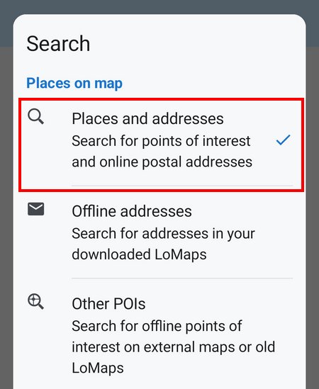
The application automatically searches from the available data, whether you are connected or not. Online mode is primary, and if no connection is available, it searches the downloaded data. You also no longer have to choose between downloaded LoMaps; the application searches across all of them, and the user interface is uniform for all. However, the latest LoMaps (June 2025) must be downloaded for the offline search to work properly.
Postal addresses, cities, and states are still searched online only in this function. For offline address searches, you need to switch the search to “offline addresses” mode. Linking online and offline, similarly to points of interest, is not yet technically possible due to the use of two independent sources.
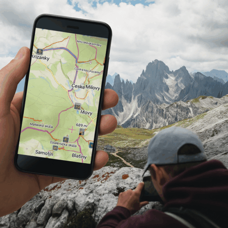
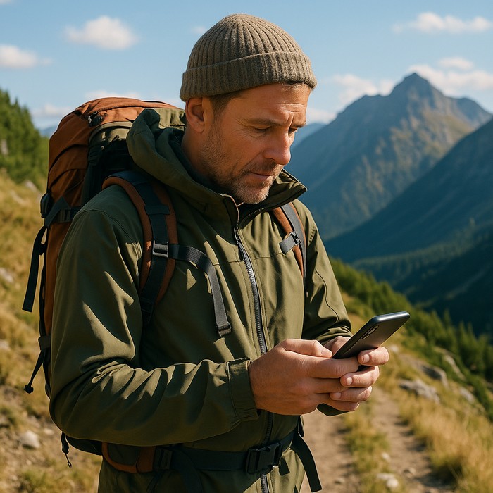
Photos over the map faster and better
We have improved the system for finding and displaying your photos above the map. Your memories of holidays or trips will now appear much faster above the map. The app can display photos not only from the default system camera folder, but also from social networking folders such as Facebook or Instagram. Of course, the choice of folders is up to you.
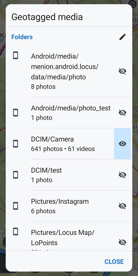
And since we all have thousands of photos on our phones, we’ve made an effective time filter for you. By a simple selection, you can view photos from today, yesterday, this month, or last month. For a more precise definition, you can set an interval from – to or even select a period from the calendar. Showing only photos from a specific holiday above the map is now a breeze.
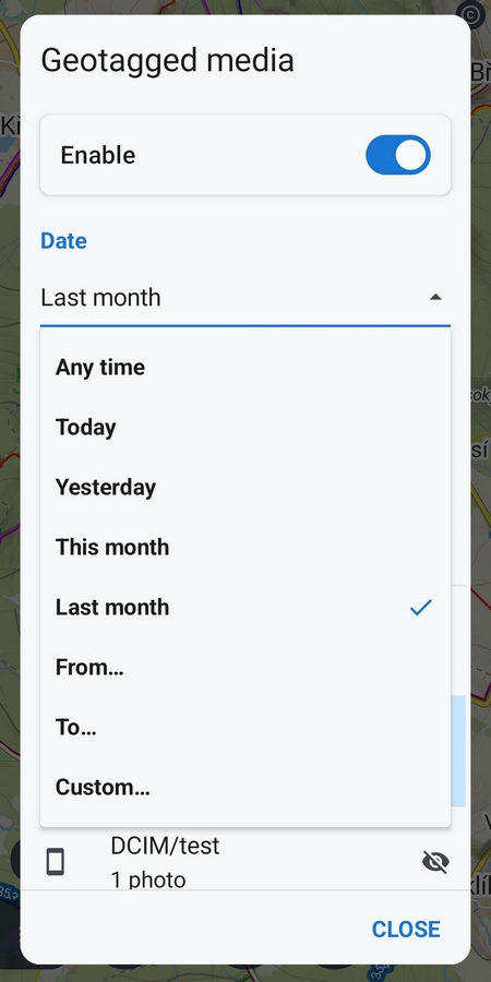
The application for working with geotagged media needs your permission to access it. The data is then only loaded locally for display purposes and not sent anywhere.
Easier application data transfer
Moving your app to another device is sometimes a necessity. Mostly this is due to buying a new mobile. Most of you don’t have to deal with anything complicated – you install Locus Map from Google Play on your new phone, re-download your maps from the Locus Store, and if you use the Premium Gold package, you download your routes and waypoints from the cloud.
However, more advanced users often need to transfer their own app settings, attachments, custom maps, and other data as well. Users switching from the old Locus Map Classic to Locus Map 4 don’t have the option to sync data to the cloud.
That’s why we’ve developed a solution using a general backup of all the data you use in Locus Map – the application migration backup can pack your entire database of routes and waypoints, including attachments, downloaded maps, and all configuration files and settings, into one large file in one click:
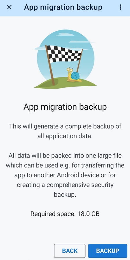
This is then moved to the new mobile and restored in the Locus backup manager. However, this has its pitfalls, especially for “power users,” where the file size can reach tens of gigabytes. Migration backups should therefore really only be used if absolutely necessary. The feature will soon be implemented in the new version of Locus Map Classic, too.
Saying goodbye to Google Drive
Unfortunately, we also have some unpleasant news for you. As of September 1, 2025, we have been forced to disconnect Locus Map and all of our other apps from Google Drive because we have been denied full access to the service. The alternate solution using Google File Picker or Android Picker is not sufficient for our usage – it doesn’t allow for backups, bulk import or export, or the automation you’re used to. New users and all those who were not signed in to Google Drive via Locus Map will no longer see this service offered.
Importing individual files from Google Drive will only be possible through the system file manager (if you have Google Drive installed on your phone), and you will be able to share the exported files on Google Drive.
Connectivity with Dropbox and OneDrive remains unchanged.

29 Comments
Podporu pre hodinky z rodiny Amazfit nemáte na pláne? Je to celkom veľký ekosystém, zišla by sa podpora. Aj kvôli tomu som sa rozhodol prejsť z classic na Silver a smola, škoda.
Dobrý den, omlouváme se, ale momentálně to v plánu není. Aplikace podporuje pouze propojení s hodinkami Garmin nebo Wear OS.
Dobrý den. Zauvažujete i o podpoře ekosystému Proton? Drive a tak?
Dobrý den, zatím o této podpoře neuvažujeme, nicméně po nuceném odpojení od Google Drive se určitě budeme ohlížet po dalších možnostech.
Hallo fleissiges Team von Locus,
ich arbeite mit Locus seit 11 Jahren und bin immer wieder begeistert über die App. Ich plane mehrtägige Radtouren und Wanderungen. Noch komme ich mit der guten alten Classic Version aus. Noch hat mich keine der vielen weiteren Möglichkeiten der größeren App überzeugt. Was mich sofort zum Upgrade bringen würde wäre eine
Modernisierung der Anzeige des Höhenprofils eines Tracks wie folgt: x- und y-Achsenbeschriftung fest einstellbar. Damit könnte man zumindest im optischen Gedächtnis oder mit Screenshots mehrere Tracks vergleichen. Das Optimum wäre, dass 2 bis 3 Tracks gleichzeitig (vielleicht durch Farben getrennt) angezeigt werden. Ich plane oft alternative Routen und würde gerne sehen, wie die Verläufe sich im direkten Vergleich unterscheiden. Die reinen Angaben der gesamten Höhenmeter als Zahl helfen nur wenig. Das Profil in der Ansicht und im Vergleich ist mir wichtig. Und um die Einschätzung einfach zu machen wiegesagt auch das feste Koordinatensystem.
Verständlich erklärt? Umsetzbar? Ich freue mich auf Eure Einschätzung!
Hi Angi, thank you for your ideas. For the best result, place them on our helpdesk at help.locusmap.eu and let other users vote for them. If your ideas gather wide support from others, we'll implement them.
Danke für die Antwort. Soeben meine Idee im Helpdesk eingetragen. Bitte um viele Stimmen, danke!
leider finde ich noch immer, wahnsinnig überhöhte Höhenmeterangaben in selbstgebauten tracks oder in importieren. wird über Werkzeuge "aktualisiere Höhe" ausgewählt, steigen diese Werte oft auch noch an. ein sehr großer Minuspunkt der App.
Hi, Locus Map processes elevation gain from the data it receives from your phone's GPS. The resulting elevation gain is also incorrect if the data is incorrect or contains huge deviations. Locus Map, however, offers a few methods to limit these deviations.
Open Locus settings > GPS&sensors:
- Location filter > select medium or heavier filter
- Google Services assisted location > turn it off
- Altitude manager > settings tab > Elevation data - select "Optimize GPS values" or "Replace GPS values"
- Altitude manager > settings tab > Pressure sensor > turn ON (if available)
- Altitude manager > settings tab > Altitude filter - select medium or heavier filter
I have the same problem, especially sometimes I experience a sudden drop in altitude for several subsequent points in a track. I know this is a problem of the GPS and not of Locus but it would be great if Locus would have a feature to fix just these obvious problems of an existing track without updating the altitude of the complete track. Currently I often manually delete these few points but I wish this could be fixed automatically.
You say "...and restored in the Locus backup manager". But for a fresh install of Locus Map the backup manager is hidden quite well. From main menu > All features > Set up > Settings > Backup & filesystem > Backup manager > Restore from backup > System file manager > select appropriate ZIP > select all > RESTORE. To search for "Backup manager" you have to search in Settings. Not intuitive.
Hi Andrew, the placement of the backup manager has always been a subject of disputations within our team. We're trying to consider all points of view, all opinions and every user or a team member has his/her own. Fortunately, the app migration is not a process that you perform every day.
La aplicación es super buena solo deberían dejar la resolución de las fotos tomadas en la grabación de rutas un poco más grandes para quienes presentamos informes sobre kmz o kml el poder tener un tamaño de foto apropiado pata esas presentaciones sería magnífico de 250 a 300 px
Hi, you can adjust this value in the expert settings, section import/export.
O un opción dentro del menú en que se pueda decidir que resolución usar para tomar fotos así abrir ese espacio pata que podamos presentar informes muy compatibles y amigables con Google heart pro web
If you need anything in the app to be changed, place it as an idea on the helpdesk at help.locusmap.eu. Other users will vote for it and when your idea gets a wide support from others, it will be implemented.
Are the No Go Areas included in tbe backup?
These data are not synced via cloud but still important.
Hi Michael, no-go points are part of the settings backup, available in auto, manual and migration backups.
"The application automatically searches from the available data, whether you are connected or not. Online mode is primary, and if no connection is available, it searches the downloaded data." - thats sound like masking an error. I.e. if no connaction available and it finds too few places, user don't understand why place is missing - because it does not exists or because no connection. And every search user will be in doubt was it "full" search or offline only.
If the phone is offline, a notifying icon emerges in the topbar of the search dialog.
Zdravím. Neviem či som ozaj len výnimka, ale po tejto aktualizácii sa mi to zdá nejaké zasekané, mrzne mi to keď si vytváram plán, alebo počas nahrávania trasy si chcem niečo pozrieť. Predchádzajúca verzia mi to nerobila, ale sa mi zdá že tá pred ňou alebo 2 dozadu mi to tiež mrzlo. Telefón mám Honor magic5 pro, takže výkonu by som mal mať dosť, Locus mám vo výnimkách zo šetrenia batérie aj z automatického zatvárania, deň pred túrou zvyknem pre istotu reštartovať telefón a aj tak mi to robí. Aj som povypínal zobrazenie nahratých trás, používam stiahnuté freemap, takže ani na signále by to nemalo zadrhávať. Ako píšem, až po aktualizácii sa mi to znova začalo zasekávať.
Dobrý den, po hlavní verzi jsme vydali ještě několik opravných updatů, tak prosím aktualizujte na poslední verzi 4.31.3. Anebo nás kontaktujte přímo na helpdesku help.locusmap.eu, probereme to podrobně.
In meiner 5-köpfigen Familie nutzen 4 Personen Locusmap Classic. Gibt es ein FamilienAbo für den Silver/Gold-Plan der 4er Version? Gooble bietet ja die Familienbibliothek zB. Oder muss ich, damit alle von den GoldVorteilen profitieren können 4 x 24€ pro Jahr zahlen?
Hi, unfortunately, Google Family program doesn't include subscriptions. If you want to use one subscription for the whole family, use one Locus account on all Locus Map installations.
Hallo liebes Locus Team,
ich habe zufällig diesen Blog-Beitrag gelesen und bin schon wieder begeistert, welche Funktionen in dieser App vorhanden sind, die ich noch nicht kenne.
Der Entfernung von Google Drive trauere ich nicht nach. Das einzig gute daran war die Importfunktion von mehreren Dateien gleichzeitig. Wenn ihr das mit einer nativen Nextcloud- oder Webdav-Integration hinbekommen könntet, wäre das genial. Gibt es dazu schon Ideen bei euch?
Hi Carsten,
at the moment, adding Nextcloud or WebDAV is not on the devs' road plan but you can vote for this idea at our helpdesk: https://help.locusmap.eu/topic/export-to-nextcloud-and-owncloud and/or https://help.locusmap.eu/topic/gpx-poi-file-import-export-to-synology. The idea is getting quite a lot of support so it's possible it'll be implemented in the future.
4.32 has still bugs, comparing to 4.31: I can't edit a track.
I hope, I can re-install 4.31
A neviete prečo mi nejde stiahnuť mapa V5 ?
Dobrý den, netuším, nabízíme pouze mapy ve verzi V4.