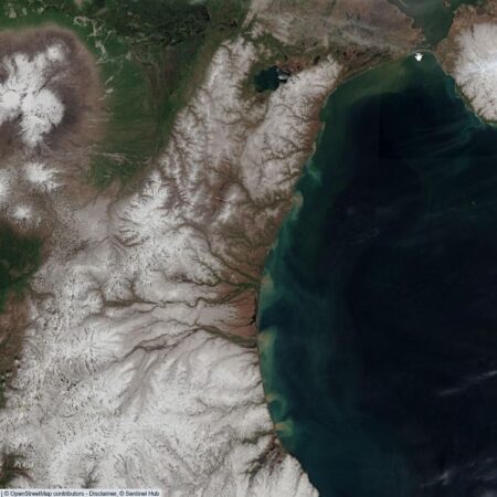
OpenStreetMap is frequently updated but depends on volunteers. Commercial maps are updated with every release. Locus Map’s aerial maps, available with the Premium Gold tier, are detailed enough, but they are updated once in a while. But what can tell you the exact state of land cover, vegetation, or snow every day? Satellite imagery, of course!
Free and open satellite imagery is collected and shared through the Landsat and Copernicus programs. Each program has its own online viewer, which can be accessed via a web browser. But is it possible to visualize your location on top of the latest satellite image or create a map of the current snow conditions and display it on your hiking map? The answer is a big yes.
The key: WMS/WMTS
The key to this is the OGC (Open Geospatial Consortium) standard: This is the set of agreements that enable web map services such as WMS (Web Map Service) or WMTS (Web Map Tile Service). If you don’t know how these work, don’t worry! The main thing is that remote servers can create a map of the location you are interested in and send it directly to your device. Locus Map is compatible with WMS/WMTS services, which means it can load any service that complies with these standards.
The source: Sentinel satellites
The Copernicus Data Space Ecosystem is the new gateway to satellite imagery from the Sentinel satellites. It is not only a portal for downloading data, but also offers visualization tools, free virtual machines, and a large code base for the developers among you. For those who want to view satellite imagery on their mobile phones, the good news is that there is also an OGC API. API stands for Application Programming Interface – essentially a piece of code that allows your phone to communicate with the servers.
A typical case you might want to load onto your map is the latest Sentinel-2 true-color image. It has a 10-meter resolution and is updated at least every five days—if cloud cover allows. The data is free, but you will need to manage your user quota through your credentials, so let us walk you through the steps.
How to get the data into the app?
In short, you will need to create a configuration for your WMS and then load it into Locus Map.
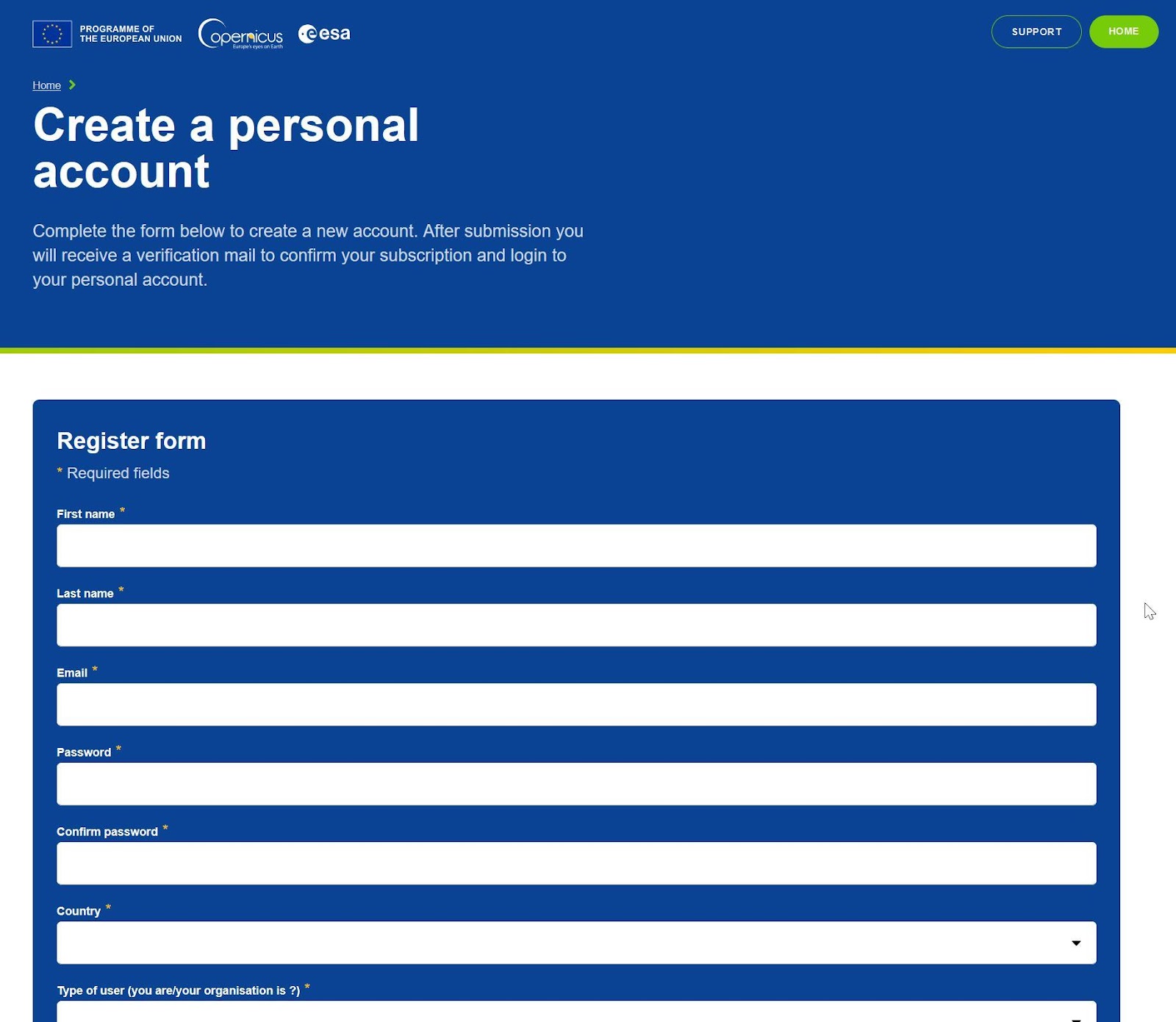
First, register at dataspace.copernicus.eu. You can view the privacy policy: No data is used for profiling, you don’t have to provide any personal information, this registration is just to ensure that no one accidentally consumes a disproportional amount of data.
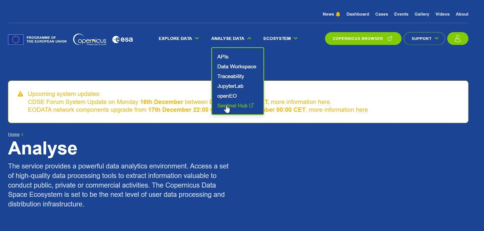
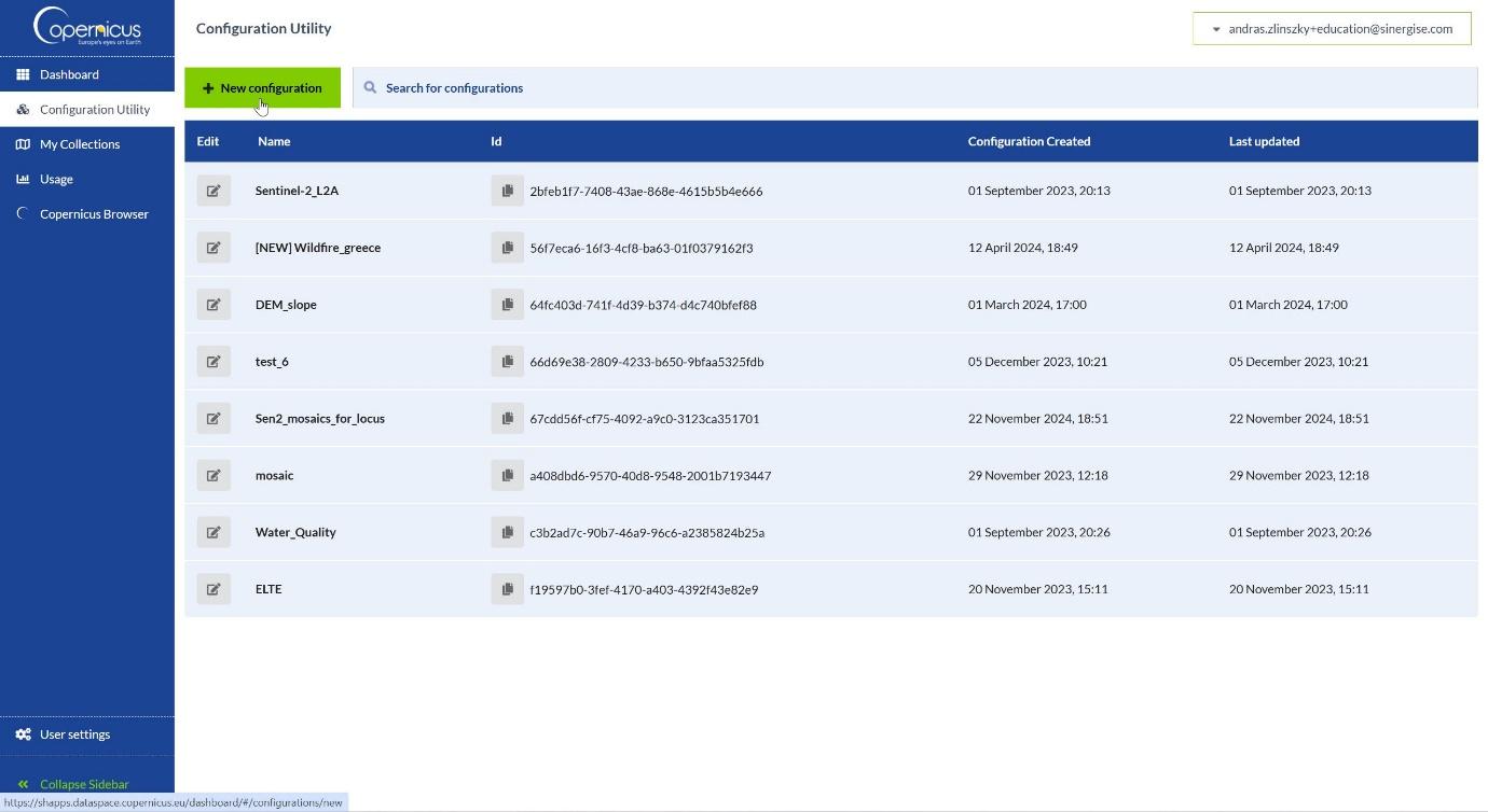
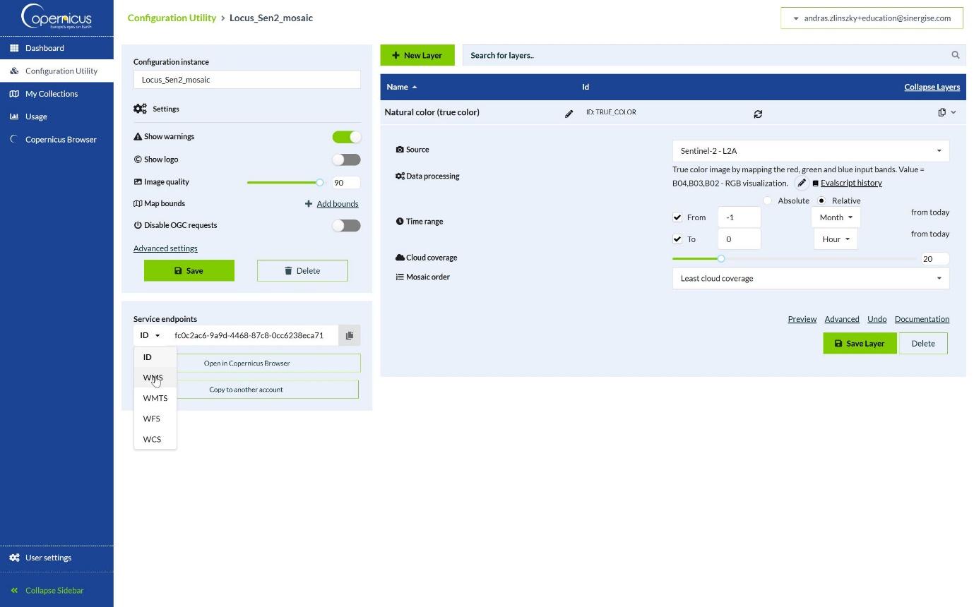
Open the Sentinel Hub Dashboard (Analyse data/Sentinel Hub), where you will find a configuration utility. If you click on „Add New Configuration” and select „Create configuration based on Simple Sentinel-2 L2A template”, you will get a new configuration with 10 different layers that you will be able to choose from within Locus.
A few settings: Click on the arrow next to the layer name on the right to access its settings. First of all, you can delete some of the layers if you don’t want to keep all of the options (you will be able to choose the layer in Locus). You can also set a time range. If you click on „relative”, you can set „From -1 month” and „to 0 Hours” from today. Also, set the „Mosaic Order” to „Least cloud coverage”. This will give you the least cloudy image of the last month – very handy if you want to know exactly what is on the ground.
On the left side under „Settings”, uncheck the „show logo” box, and under „Service endpoints” click on “ID” and scroll down to select WMS. You will see a URL with a long code at the end. Copy this code.
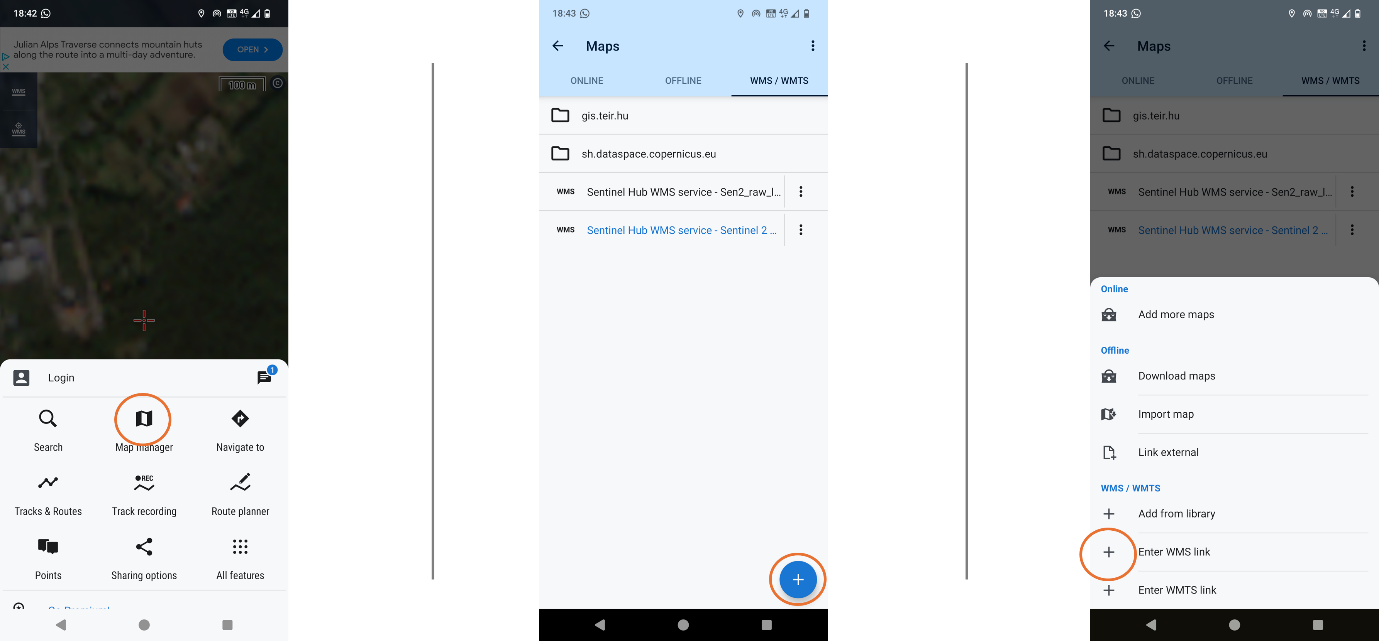
Open the Map Manager on Locus Map and select the WMS/WMTS tab. Click on the plus symbol in the bottom right-hand corner. Enter the long URL, add your CDSE username and password when prompted, and you should be good to go.
If you enable this WMS and select a layer (typically you would want to use true color), the latest Sentinel-2 satellite image of the area you are displaying on your map will be available.
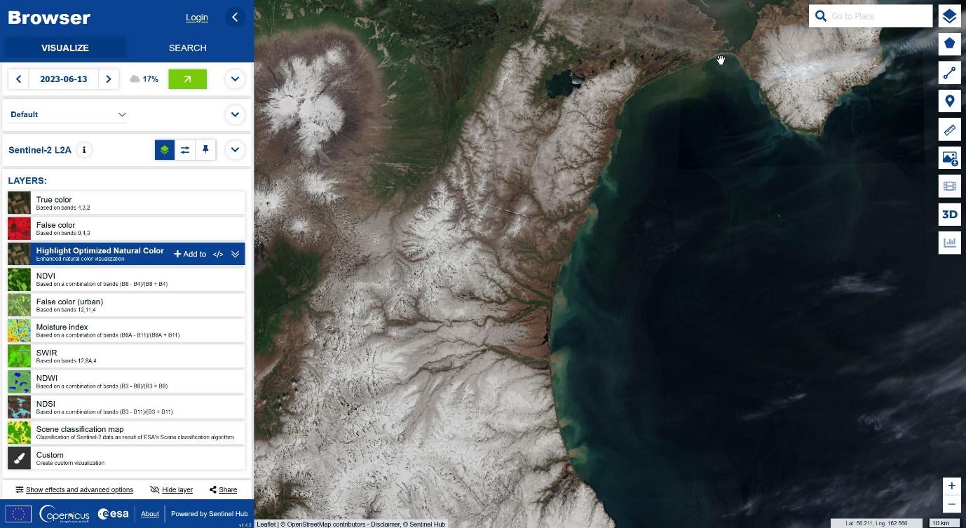
Once you have this image, you can set some additional details. Open Copernicus Browser at browser.dataspace.copernicus.eu and take a look at the available datasets and visualizations. There is an in-app tutorial (a short tutorial can be found here if the controls are not self-explanatory). You can select the available layers from the list, or you can also explore the extensive collection of additional visualization tools in the Custom Script Repository, including predefined scripts for applications such as wildfire or flood mapping- or even create your own!
Once you have found the dataset of your choice, open the Sentinel Hub configuration utility. Here you can create a new configuration with the exact settings you used in the Browser, to send the visualization to Locus Map on your phone. You can find detailed instructions on custom scripts and configurations in this blog post. Select the template for the dataset of your choice (typically „Simple Sentinel-2 L2A template”) and create a new configuration. Here you can again create a new layer and copy the visualization script of your choice into the „Data Processing” part of the new layer definition.
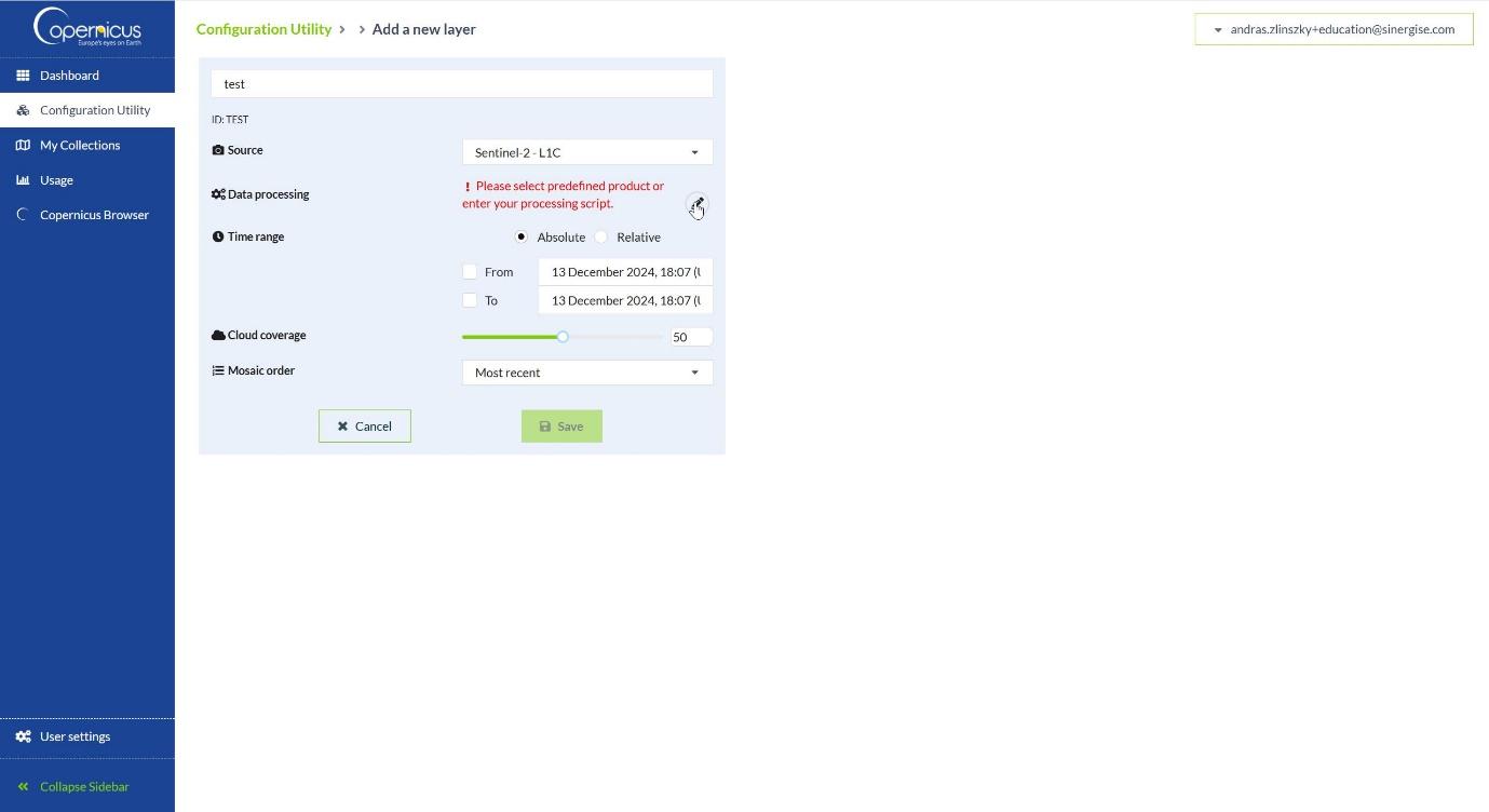
You can then create a WMS from this layer in a similar way and open it with Locus Map.
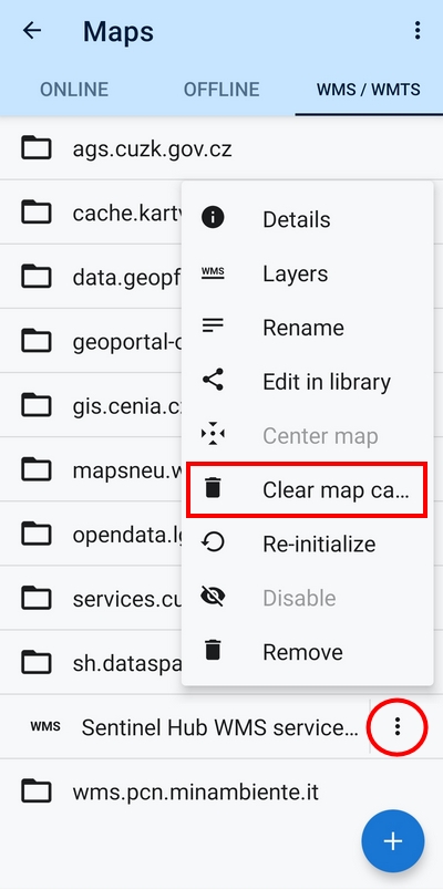
And don’t forget to clear the WMS layer cache each time you need fresh data from the server:
As you will see, the possibilities of satellite imagery are almost limitless, and having it directly in your mapping application creates a whole new level of awareness of your surroundings. Whether it’s finding the right panoramic point, or supporting your work as a first responder, we hope you will find satellite imagery on your phone both useful and inspiring. The future is now!

András Zlinszky is a science communication expert and environmental activist. He works at Sinergise and is responsible for the promotion of the Copernicus Data Space Ecosystem. Outdoors, he likes kayaking, mountain biking, hiking, and parkour. His favorite trip-planning trick is to travel light and bivouac in caves.
LinkedIn
X


22 Comments
Wow that are uptodate images! Thanks for the tutorial. Do you have more wms sources?
Hello, resolution is very low in the "Natural Color" map. May be I'm doing something wrong?
- Copernicus Data Space Ecosystem offers many data sources, you can create a WMS from any dataset listed here: https://documentation.dataspace.copernicus.eu/APIs/SentinelHub/Data.html#listing-Sentinelhub_data-page=1
- The resolution of the Sentinel-2 Natural Color product is 10 meters, lower than airborne imagery or commercial high-resolution satellite imagery, but free and updated every 3-5 days
Thanks for your answer!
For me it doesn't seem 10 meters of resolution.
The satelite images from Google Maps are way more detailed. The frecuently updated images from Copernicus is a great advantage but by now not useable for my needs.
Thanks for all the info!!!
I noticed that too. I think it's just to see what kind of ground cover there is.
I use Satenlite images normally to see if there is a path there after all. Or if you can walk on it somehow. Unfortunately the images from Google are often too old. I often can't see anything in the forest. Only if it's a picture in winter where there's no snow.
would work here but the resolution is too poor.
Many thanks for the article and the detailed instructions! I hadn't dealt much with WMS/WMTS before, but have now tried it out and it's very interesting.
I don't have any "professional" application needs, but even for purely private reasons, these are fascinating possibilities!
Gdzie pobrać ten plik?
Nic się nie zgadza z opisem.Nie wiem skąd te zrzuty ekranu ale na pewno nie z aktualnej strony Copernicus.l
Hi,
Does this relate to locus v 3.70 also ?
Because i dont get it done correctly..
Thanks
Yes, it should work in LM Classic too.
Thanks for sharing, but -
Resolution very poor 😞,too poor to trust
Hi Udi, the resolution of these satellite images is sufficient for evaluation of vegetation or snow cover of the landscape. It's not for mapping your hikes.
Hi folks, easy to register and easy to Login but can not open the Hub, I'm getting always back to the Login screen. Did I something wrong during registering?
... did something wrong, the subscription is not the verification in once, verification mail sent when tryed to access the Hub not during register...
For technical questions related to Copernicus Data Space Ecosystem please use https://forum.dataspace.copernicus.eu/ - experts are there to help
Unluckily, still a long way to go before getting the resolution required for most outdoor activities (hiking etc), as offered by OSM and Google. But the way is in the right direction 👍
Hi Gerhard, the satellite images from the Copernicus project can help when you need to assess vegetation or snow cover of the land. It's not for mapping your hikes.
I click on "true color" but there is "unknown problem" displayed on map. Also what EPSG should i use.
Please report in the CDSE forum (https://forum.dataspace.copernicus.eu/c/apis/31) and our experts will check and get back to you
Newer mind. Re instal of Locus help.
Hi Guys, I tried your guide, but I get error code 400 when trying to display the map..?
Hi Pawel, this error means the third-party server is unavailable. Please check the URL or wait until the server is back on.