Am 1. März erschien auf Twitter die Nachricht, dass Viewranger, unsere sehr starke Konkurrenz-App, von ihrem neuen Besitzer Outdooractive abgeschaltet wurde. VR-Nutzer sind nun gezwungen, die Outdooractive-Anwendung zu verwenden. Allerdings sind nicht alle mit dem Upgrade zufrieden und suchen nach einer Alternative. Viele wenden sich an uns und möchten wissen, was Locus Map kann. Dieser Artikel richtet sich in erster Linie an diese.
Locus Map ist genau das, wonach Sie suchen
Der Viewranger war großartig und hat uns in vielerlei Hinsicht inspiriert. Deshalb finden Sie in Locus Map mehr oder weniger alles, was Sie in Viewranger verwendet haben. Ob Basics wie Aktivitätsaufzeichnung, Routenplanung, Navigation, Nutzung verschiedener Karten … oder Spezialitäten wie Live Tracking (ähnlich VRs „Buddy Beacon“), Augmented Reality (ähnlich dem beliebten „Skyline“) oder Wearables-Unterstützung (Wear OS, Tizen und Garmin).
Sehen wir uns jeden Artikel genauer an:
Aktivitätsaufzeichnung
Alle Ihre Outdoor-Aktivitäten können in Locus aufgezeichnet werden. Wählen Sie einfach die Art der Aktivität aus und drücken Sie die Starttaste. Diese gibt es nicht nur direkt in der App auf dem Hauptbildschirm, sondern auch im Widget oder als Add-on in der Smartwatch.
Bei der Aufzeichnung erstellt die Anwendung eine Reihe von Statistiken. Neben den vom GPS erhaltenen Parametern (Länge, Geschwindigkeit, Zeit, Höhe …) zeichnet es auch Daten von angeschlossenen Sensoren auf – Herzfrequenz, Trittfrequenz, Leistung usw. Diese Daten können direkt über der Karte auf dem sog Armaturenbrett:
Jede Aktivität hat ein eigenes Rekordprofil, das sehr detailliert angepasst werden kann. Sie können eine unbegrenzte Anzahl von Profilen für verschiedene Arten von Aktivitäten haben.
Die Aufzeichnungen werden in einer Datenbank in einer Anwendung gespeichert, die mit der Cloud und der Webbibliothek synchronisiert wird.
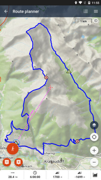
Routenplanung
Über den Planer können Sie Routen direkt in der Anwendung planen, mit oder ohne Internetverbindung. Wer einen großen PC-Monitor bevorzugt, kann Routen im Webplaner planen. Die Route daraus wird automatisch mit allen Geräten synchronisiert, auf denen Sie Locus Map installiert haben.
Die Routenplanung erfolgt auch anhand von Profilen, in denen Sie die Art der Aktivität auswählen – der Router wählt dementsprechend die geeigneten Arten von Routen, Oberflächen und Höhen der Route aus. Natürlich gibt es einen manuellen Modus zur Planung von Routen außerhalb der kartierten Routen oder die Option, eine komplette Rundtour entwerfen zu lassen – einfach Richtung und Entfernung eingeben.
Navigation
Sie können in Locus auf mehrere Arten navigieren. Die erste Möglichkeit ist entlang einer bereits vorbereiteten Route – im Planer geplant, von woanders importiert oder zuvor aufgezeichnet. Außerdem kann das Navigationsziel direkt auf der Karte angegeben werden und Locus plant nach den eingegebenen Kriterien eine Route dorthin.
Eine weitere Option, die Sie besonders in offenem Gelände ohne Straßen schätzen werden, ist die Luftlinienführung zum Ziel. Besonders beliebt ist die Methode bei Geocachern.
Wählen Sie eine Karte nach Ihren Bedürfnissen
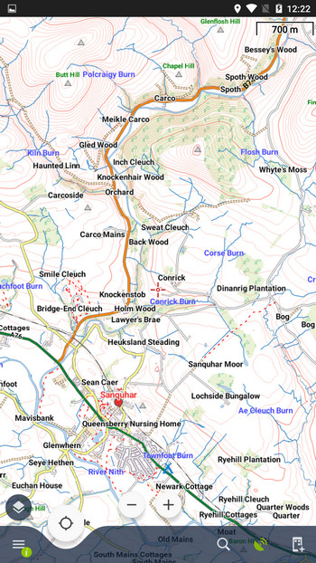
Locus Map bietet standardmäßig eine Wander-/Fahrradkarte der ganzen Welt – LoMap. Es basiert auf OSM-Daten und kann online und offline genutzt werden. Neben Kartendaten enthält es auch dynamische LoPoints, Offline-Adressen und Höhendaten.
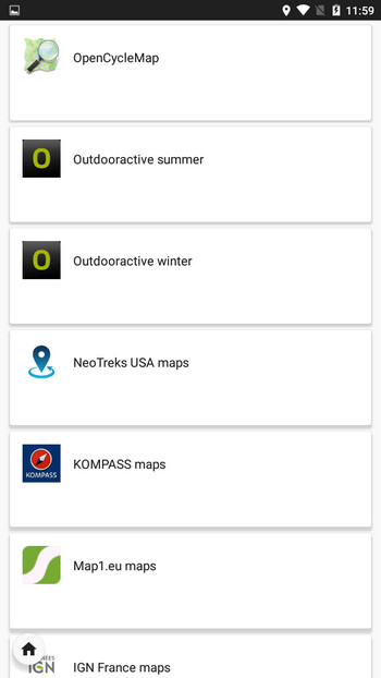
Wie der Viewranger bietet auch Locus Map Karten verschiedener anderer Anbieter an – Kompass, Outdooractive (DE), Freytag-Berndt (A), IGN (FR, BE), USGS, Neotreks / Accuterra (USA), Ordnance Survey (UK). ), sowie viele frei zugängliche Online-Karten auf Basis von OSM.
Ordnance Survey Karten
Die meisten Viewranger-Benutzer, mit denen wir gesprochen haben, verwenden Betriebssystemkarten. Wir haben sie auch in unserem Locus Store in 140 Offline-Paketen, die ganz Großbritannien abdecken. Karten werden nicht wie bei Viewranger abonniert, sondern einzeln gegen Einmalzahlung erworben. Jedes Paket enthält zwei Kartenebenen – Landranger und Explorer – in mehreren Zoomstufen.
Wir können Ihnen auch Ordnance Survey OpenData-Karten in Kombination mit OSM-Daten, Rowmaps und Core Path-Karten in JohnThornMaps anbieten, die ganz Großbritannien abdecken.
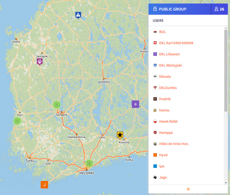
Live-Tracking ist das neue Buddy Beacon
Mit Live Tracking können Sie den Standort in Echtzeit mit Familie und Freunden teilen. Es funktioniert sowohl gegenseitig – zwischen einzelnen Locus-Benutzern – als auch einseitig – der Standort von Locus im Handy wird auf der Website angezeigt.
Sie können Ihren Standort öffentlich oder in einer privaten Gruppe teilen. Sie können Gruppen erstellen und andere Teilnehmer einladen, Sie können auch in ihnen chatten und sich gegenseitig interessante Punkte senden.
Verwenden Sie eine Smartwatch
Sie können Locus Map auch in Verbindung mit einer Smartwatch verwenden. Wir unterstützen Wear OS, Tizen (ältere Samsung-Uhren) und Garmin-Plattformen.
In allen Fällen ist Locus Map die Hauptanwendung auf dem Mobiltelefon und die Uhr fügt ein zusätzliches Add-On hinzu, das Ihren Standort auf der Karte anzeigt, Navigationsbefehle enthält und Sie auch zur Steuerung der Trackaufzeichnung verwenden können.
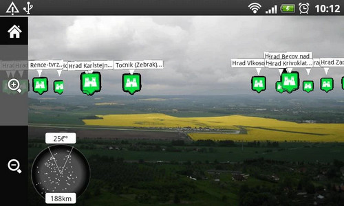
Wo ist Skyline?
Sie können auch die beliebte Augmented-Reality-Funktion mit Locus ausprobieren, indem Sie das Add-on „Augmented Reality for Locus Map“ verwenden. Im Prinzip funktioniert es ähnlich wie Skyline, aber vor dem Einschalten müssen Sie zuerst die LoPoint-Ansicht einschalten und die Berggipfel in Locus hervorheben.
Kann ich Locus Map anpassen?
Ja, in vielerlei Hinsicht.
Ausgehend vom Hauptbildschirm, der für Rechts- und Linkshänder angepasst werden kann, können Sie die Sichtbarkeit aller Hauptschaltflächen sowie der Funktionsschaltflächen in den Seitenleisten anpassen.
Sie können den Stil von Routen auf allen Ebenen festlegen – für die gesamte Anwendung, Routenordner, Navigation, Routenaufzeichnung und im Planer.
Passen Sie die Anzahl und das Layout der Elemente im Hauptmenü an, legen Sie Einheiten, Koordinatensysteme, Hilfsgrafiken, Koordinatengitter und sogar das Aussehen und die Größe von Karten- und Navigationscursoren fest.
Wofür muss ich in Locus extra bezahlen?
Die Anwendung ist in der Basisversion nach dem Download aus dem Google Play Store KOSTENLOS. Es enthält im Grunde alles, was man für den täglichen Outdoor-Einsatz braucht – Trackaufzeichnung, Routenplaner, Navigation, Rad-/Wanderweltkarte online und vieles mehr.
Sie können die Funktionalität erweitern und Einschränkungen für einige Funktionen der Anwendung aufheben, indem Sie Premium Silver- und Gold-Pakete erwerben.
Premium Silver bietet einen größeren Kartenbildschirm ohne Werbung und enthält eine Reihe von Funktionen für die sportliche Nutzung als Audiocoach oder Sensorverbindungsmanager. Es gibt auch ein Paket mit Kartenwerkzeugen für Kalibrierung, Überlagerungen und Kartenversätze.
Premium Gold bietet das Maximum – alle Funktionen inkl. Datenabgleich mit der Cloud, eingebauter Offline-Router, alle Offline-LoMaps der Welt, Satellitenkarte, Live-Tracking mit privaten Gruppen etc.
Einen detaillierten Vergleich der Premium-Pläne finden Sie HIER >>
Karten unserer Handelspartner sind nicht in Premium-Paketen enthalten. So kann jeder genau die Karte kaufen, die er wirklich braucht.


41 Comments
I am an avid hillwalker/hiker, based in Scotland. As an x-VR user I initially used the OutdoorActive app when VR was swapping over. I say used in the most basic term, OutdoorActive was useless and did not come anywhere near to VR functionality. I was desperate for a good VR replacement, and 3 days ago a friend pointed me to Locus Maps. That friend is now my BEST friend. Absolutely brilliant. I have set it up just as I want for routes, recording, statistics etc and have been out on my local hills testing it yesterday and today. It is superb, in fact, and believe me I don't say this lightly, at this point I would rate it better than VR. I subscribed to the Premium Gold, and have the OS maps that I need for my days in the hills. If there is one point to make, and this is purely a personal one, I also like Harvey Maps for the Scottish mountains. Now that would be a bonus. Thanks Locus Maps, you have done a wonderful job. John
Thanks John!
That friend would really like it to be extended to iPhone. Please when?
Working on it, but it's quite a bit of a way to go...
Hi Michael, As a follow up to my first post on this x-VR blog (15.3.22), I am finding out so much more about the app which is just brilliant. One question I have. Once a track has been recorded and saved, there is a fantastic set of statistics, one of which is the expanded Best Interval data where I can view stats per km or whatever setting I choose. Brilliant. However, this is on the android app. When the tracks are sync’d and I access them on my laptop (Windows 11) via the online Planner and My Library there is still a good selection of statistics available, but not the Best Interval extended data (e.g. data per km etc). Any chance this could be a feature on the Planner, My Library when accessed via a laptop. Thanks John
Another long time VR/IPhone user desperate for Locus on the Apple platform! Please…
We've started some preparations but it's a long way to go yet before there is anything usable.
Hi as an ex VR user & now using Outdooractive. I am interested in usage in Ireland. Would you have any plans of offering OSI or East West maps ?.
Hi Ray, yes, we've been discussing the cooperation with OSI for some time. Hopefully it'll go on successfully.
Hallo an die Macher und Gratulation,
seit vielen Jahren nutze ich schon die Apps von Locus, meine Begeisterung für diese Map ist ungebrochen. Danke auch für die steten und sinnvollen Weiterentwicklungen. Sicherlich ist es schon so, dass man nicht erwarten darf, dass Locus Map mit der sesselhaften Bequemlichkeit eines Autonavigationsgerätes konkurrieren möchte. Locus Map kann mehr, viel viel mehr. Einsteigern würde ich raten, Schritt für Schritt die Einstellungen gemäß der eigenen Wünsche abzuarbeiten.
Für mich gibt es zu Locus Map keine Alternative, was aber in der Hauptsache mit meinem Anspruch zu tun hat. Mit der Nutzung von GPS habe ich Mitte der 90er Jahre mit den Geräten von G…in begonnen, Waypoints konnte man setzen und sich diesen per Näherungsmethode anpeilen, mehr nicht, Streckenführung gleich Fehlanzeige. Seit vielen Jahren nutze ich nur noch Locus auf dem Android-Smartphone u. Android-Tablet, was auch der Hauptgrund ist, warum ich kein IPhone verwende.
Super ist nun, dass ich seit Locus Map 4 auch diese Map auf meinem iMac und iPad nutzen kann und das mit stetem Datenabgleich.
Nur eine Bitte um einen Hinweis habe ich, bei der Spiegelung der Tracks u. Routen auf den iMac und das iPad, erfolgt dieses ohne pfeilartige Richtungsmarkierung. Habe ich da etwas übersehen?
Ansonsten besten Dank und hoffentlich weiter so.
Hi Fritz, we've tested it on an iMac and it functions normally... what kind of Mac and what version of Safari browser do you use? Better if you contact us at https://help.locusmap.eu/ticket/add and send a screenshot so that we are sure we know what you mean.
Traduction en français SVP
Try Google translator or DeepL.
I have been a viewranqger user for many years and had purchased the Irish OS maps. This week Viewranqger stopped working. I am paying for Outdoor active but the Irish maps are not available yet. Also the Opencycle map is not the public available version and shows none of the Irish Greenway ( the Opencycle map in AlpineQuest does. What is the situation in Locus?
Hi, Irish OS is not yet available but we are negotiating cooperation with them. Opencycle maps are available online and for download.
Locus pouzivam od r 2017. Supr app. Tento rok som si kupil galaxy watch 4. Zial kupil som si Outdooractive len kôli tomu že na hodinach spustiš app nezávisle od telefonu. Casto sami stáva že idem nalahko iba s hodinami. Locus pochlapte sa.
Standalone watch add-on je v plánu, ale momentálně na něj není čas.
Dik. V dnesnej dobe kvalitnych hodin to bude nevyhnutnost. Mam tam aj SIM cize nezavislost od telefonu parada. Tesim sa ked to bude.
I’m an ex-ViewRanger user and after 11 years of excellent service I’m very sorry that it’s being closed down.
Locus maps sounds like a very good replacement but, like others, I would very much like to see the Apple version as soon as possible! But if it’s going to be a long time, I might have to buy an Android device just to use it.
I’m living in Ireland so would hope OSI and OSNI maps are available soon.
By the way I’ve used the JohnThorn maps in the past and they are excellent.
Keep up the progress and good luck with getting the Apple version going as soon as possible.
iPhone user here, a ViewRanger user since 2016, but I am not satisfied with the Outdoor active app. Looking forward to the launch of Locus Map on Apple Store
Yes, indeed it is difficult to understand the closure of Viewranger. Outdooractive is much worse, it is another thing, nit dit cyclists or walkers but dit tourists...
Fortunately Locus Maps is an excellent alternative! Thank you!
But please do not fall into the temptation to sell the enterprise to another monster that pays you but makes it disappear an excellent app!
This is the sad lesson of the disappearance of Viewranger.
Thanks, Locus Maps, t'he app is great!
Hi
Another ex VIEWRANGER user!
I have a problem in that no matter what I do in app and battery settings all I get when recording a track is a straight line. Please help
Regards
Rob
Hi, please get Locus Map permission for all-time access to location and exclude Locus from all means of battery optimization so that the app can run in the background. Instructions on how to do it are summed up here: http://docs.locusmap.eu/doku.php?id=manual:faq:gps_lost_fix_android6 or here: https://dontkillmyapp.com/.
Hello, thats all really shit! I made a *.rmap with CompeGPS Land. How is it easily possible to get it into my directory-system in the "maps" directory of Locus??? Improting odes not work, copying into the designated sub-directory does not work.
Hi, when you get calm, contact us at help.locusmap.eu and tell us more - does any error message appear? Also, send the .rmap file for testing.
Hi Michael, As a follow up to my first post on this x-VR blog (15.3.22), I am finding out so much more about the app which is just brilliant. One question I have. Once a track has been recorded and saved, there is a fantastic set of statistics, one of which is the expanded Best Interval data where I can view stats per km or whatever setting I choose. Brilliant. However, this is on the android app. When the tracks are sync’d and I access them on my laptop (Windows 11) via the online Planner and My Library there is still a good selection of statistics available, but not the Best Interval extended data (e.g. data per km etc). Any chance this could be a feature on the Planner, My Library when accessed via a laptop. Thanks John
Hi Michael, Re Version 4.8.2 - Best Interval is not showing. I have updated to version 4.8.2 and since the update the Statistics screen Best interval displays the message "No Intervals here. This route/track can't be divided into intervals as it doesn't contain any time values" This is on all tracks, newly recorded since update and on old tracks prior to update which did show the Best interval data, and extended data. However, on my second phone with app, which is still running Version 4.8.1, all of the Best interval data is still available. So is there a glitch with V 4.8.2? Thanks John
Hi John,
thanks for the report. The error has been fixed. Please wait for the next app version.
I had wiewranger for some 7 years. Fantastic!!! Simple, practic....Tried outdore...could not use as I needed...SHIT!!!!!!!! Those people should switch out outdore no WR!!!!!!!!!
Found locus. Positive, that you have OSM. I need to see and quickly use all my tracks ON the map and switch between tracks quickly. Here LOcus is far behind WR. To many taps. Can not select one truck between others in red and use for driving. There is the label on,can not moove the map, after tap its lost. You need to do it as in WR!!!!
Today I tried to draw new track in PC, but could not save and sinchronize between PC and phone. Lost few hours, not sucsess...
Hi, we understand it's hard to move to an unknown software from a well-known one. Give it some more time. To display all tracks in a folder on the map - tap the folder icon. To select the track directly on the map - tap it, and select "navigation" from the bottom menu. Synchronizing routes from the web with the app needs Premium Gold purchased/subscribed. Etc. The user manual can help, see https://docs.locusmap.app. Or contact Locus community at help.locusmap.eu and forum.locusmap.eu.
Ex viewranger user, thank you very much for this alternative which is even more complete than ViewRanger. The application is really great with many useful tools, keep it up!
The only nice tool missing from locus map that was on VR is the ability to associate photos taken with a recorded route.
Hi Paul, this is possible also in Locus. Either during the track recording (open recording panel, tap the blue "add point" button, select "add point (photo)"). Or you can attach photos to a saved track - open the track detail > tap ">" in the waypoints section > add new > add attachment > select photo.
Hi, actually not a viewranger user, but I read the article anyway :)
Since you mentioned Ordnance Survey maps and routing in the same article, I wonder whether the two will work together. I don't mean whether I can overlay routes over Ordnance Survey maps, which would probably work. I mean that the route calculation actually uses Ordnance Survey data for calculating the route. The online route calculator probably just routes on static OSM data, but what about the offline route calculator included in Silver? Will it actually route using data from the shown map or also use some OSM database underneath?
Hi Thomas, all routers available in Locus Map generate routes from OSM data, also LoRouter Offline.
Where can I subscribe to iphone users waiting list? I miss the VR
HI LOCUS-Team
Erst mal Gratulation - LOC4 ist einfach spitze !
Es gibt wenige WanderNAVI-Apps, die ich noch nicht ausprobiert habe, da die Funktionen bei >97% nicht annähernd den Umfang haben wie LOC.
Auch mit dem neuen Design und den Funktionen wieder ein Schritt um die BESTEN zu bleiben.
Bis jetzt war ich mit der @apemap sehr zufrieden, da die etwa die Funktionen wie LOC hat.
Bei allen vermisse ich allerdings eine Funktion, die bis jetzt nur die "GPSies" App hatte (wurde in "AllTrails" integriert), wo man die Touren als "CSV-Dateien" in eine Exel Tabelle abspeichern konnte.
Wenn ihr auch das noch hinbringt, dann seid ihr SOWIESO DIE ALLERBESTEN VON DEN BESTEN !! (Darf dann auch im monatl. Abo gern der eine oder andere Cent mehr sein)
Hi Martin,
thanks for your kind words. And watch out - Locus Map supports track export to CSV format, see https://docs.locusmap.app/doku.php?id=manual:user_guide:tracks:export#supported_export_formats
Liebes Locus Team eine super App, nur bei Locus4 ist schaade, dass das Hinzufügen eines Sensors und der Download der Schattierung und Höhendaten nicht in der kostenloser Version verfügbar ist. Vorher bezahlte ich in der Proversion einmalig acht Franken, jetzt sind es alle Jahte zehn Franken. Daher bleibe ich bei der Version 3. Gruss Barbara
Well, I still am using VR, nah that's a lie, I still have it on my mobile and tablet, downloaded a pre shutdown package and got everything back🙂 so I could get all my tracks from all the years of VR...
Now happily using Locus Map 👍 have imported all my tracks and waypoints so I don't need VR anymore. One question, can we get the whole of the UK on one 1:2500 scale? Instead of the bitty maps? Also, can we get the OS maps as vector maps instead of rasterized?
Apart from that, I'm happy to be starting a new chapter with Locus Map 👍🙂
Thanks
Ian
Hi Ian,
we've accepted what Ordnance Survey offered to us for the most reasonable price. However, we've still been negotiating with them about a subscription-based model.
Thank you Michal. Look forward to seeing what you can negotiate with Ordnance Survey! Keep up the good work :-)