1.března se na Twitteru objevila zpráva, že Viewranger, naše velmi silná konkurenční appka, byla vypnuta svým novým majitelem, společností Outdooractive. Její uživatelé jsou tak nyní nuceni používat již pouze stejnojmennou aplikaci Outdooractive. Ne všichni jsou však s tímto krokem spokojeni, a tak hledají alternativu. Mnozí se obracejí na nás a chtějí vědět, co Locus Map umí. Především těm je určen tento příspěvek.
Locus Map je to, co hledáte
Viewranger byl skvělý a v mnohém jsme si navzájem byli inspirací. Proto u nás najdete víceméně vše, co jste používali ve Viewrangeru. Ať už jsou to základy jako záznam aktivity, plánování tras, navigace, využití různých mapových podkladů… nebo speciality jako Live Tracking (u VR “Buddy Beacon”), augmentovaná realita (oblíbený “Skyline”) nebo podpora wearables (Wear OS, Tizen a Garmin).
Podívejme se na jednotlivé položky podrobněji:
Záznam aktivity
Veškeré vaše aktivity v přírodě lze v Locusu zaznamenat. Stačí zvolit druh aktivity a zmáčknout tlačítko startu. To máte k dispozici nejen přímo v aplikaci na hlavní obrazovce, ale také ve widgetu nebo v pomocné aplikaci v chytrých hodinkách.
Při záznamu aplikace generuje množství statistik. Kromě parametrů získaných z GPS (délka, rychlost, čas, převýšení…) zaznamenává také údaje z připojených senzorů – tepovku, kadenci, výkon atd. Tyto údaje se mohou zobrazovat přímo nad mapou na tzv dashboardu:
Každá aktivita má svůj profil záznamu, který lze velmi detailně upravit. Profilů pro různé druhy aktivit můžete mít neomezené množství.
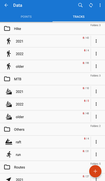
Záznamy se ukládají do aplikace, která se synchronizuje s knihovnou na internetu.
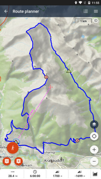
Plánování tras
Trasy můžete plánovat přímo v aplikaci prostřednictvím plánovače, a to s připojením k internetu i bez něj. Pokud dáváte přednost velkému monitoru PC, můžete trasu naplánovat ve webovém plánovači. Trasa z něj se automaticky synchronizuje se všemi zařízeními, ve kterých máte nainstalovaný Locus Map.
Také plánování trasy se provádí pomocí profilů, ve kterém zvolíte druh aktivity – podle ní router volí odpovídající typy cest, povrchy a výškový průběh trasy. Samozřejmostí je ruční režim pro plánování tras mimo zmapované cesty nebo možnost nechat si navrhnout komplet okružní trasu – stačí zadat směr a vzdálenost.
Navigace
Navigovat můžete v Locusu několika způsoby. První možností je podél již připravené trasy – naplánované v plánovači, importované odjinud nebo dříve zaznamenané. Dále lze přímo na mapě určit cíl navigace a Locus do něj naplánuje trasu podle zadaných kritérií.
Další možností, kterou oceníte zejména ve volném terénu bez cest, je navádění na cíl vzdušnou čarou. Metoda je oblíbená zejména mezi kačery.
Vyberte si mapu podle svých potřeb
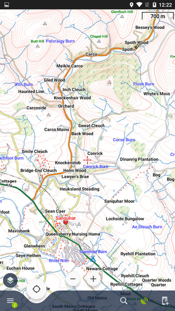
Locus Map nabízí jako výchozí podklad cyklo/turistickou mapu celého světa – LoMapu. Jejím základem jsou OSM data a lze ji používat online i offline. Obsahuje kromě mapových dat také dynamické body zájmu LoPointy, offline adresy a výšková data.
Stejně jako Viewranger, i Locus Map nabízí mapy řady dalších poskytovatelů – Kompass, Outdooractive (DE), Freytag-Berndt (A), IGN (FR, BE), USGS, Neotreks/Accuterra (USA), Ordnance Survey (UK), a také spoustu volně přístupných online map na bázi OSM.
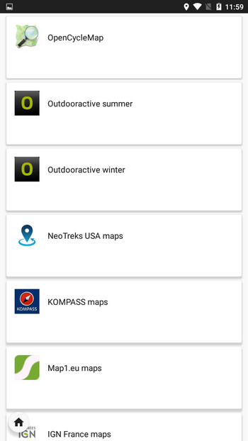
Mapy Ordnance Survey
Většina uživatelů Viewrangeru, se kterými jsme měli možnost mluvit, používá mapy OS. Máme je také v našem Locus Store, a to ve 140 offline balících, pokrývající celou Velkou Británii. Mapy se nepředplácejí jako ve Viewrangeru, ale kupují jednotlivě za jednorázové platby. Každý balík obsahuje dvě mapové vrstvy – Landranger a Explorer – a to v několika měřítkách.
Ve can offer you also Ordnance Survey OpenData maps combined with OSM data, Rowmaps and Core Path maps in JohnThornMaps covering the whole UK.
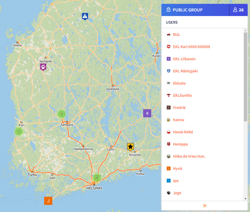
Live Tracking je nový Buddy Beacon
Sdílet polohu v reálném čase s rodinou a přáteli můžete pomocí funkce Live Tracking. Ta funguje jak vzájemně – mezi jednotlivými uživateli Locusu – tak jednosměrně – poloha z Locusu v mobilu se zobrazuje na webové stránce.
Polohu můžete sdílet veřejně nebo v uzavřené skupině. Skupiny můžete vytvářet a zvát do nich další účastníky, můžete v nich i chatovat a posílat si navzájem body zájmu.
Používejte chytré hodinky
Locus Map můžete používat také ve spojení s chytrými hodinkami. Podporujeme platformy Wear OS, Tizen (starší hodinky Samsung), a také Garmin.
Ve všech případech je Locus Map v mobilu hlavní aplikace a v hodinkách běží pomocný add-on, který zobrazuje vaši polohu na mapě, navigační příkazy a můžete jím také ovládat záznam trasy.
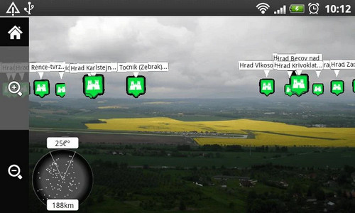
Kde je Skyline?
Oblíbenou funkci se zapojením augmentované reality můžete s Locusem také vyzkoušet, a to pomocí add-onu Augmented Reality for Locus Map. Principielně funguje podobně jako Skyline, před jeho zapnutím je ovšem nejdříve potřeba v Locusu zapnout zobrazení LoPointů a zvýraznit vrcholy. Každopádně budeme rádi, když nám dáte vědět, zda tato funkce opravdu stojí za to. Protože je to jedna z oblastí, kde máme velké mezery.
Můžu si Locus Map přizpůsobit?
Ano, mnoha způsoby.
Začněte na hlavní obrazovce, kterou lze uzpůsobit pro praváky a leváky, lze nastavit viditelnost všech hlavních tlačítek, a také tlačítka funkcí v postranních panelech.
Nastavit můžete styl tras na úrovni aplikace, složky, navigace, při záznamu trasy i v plánovači.
Přizpůsobte si počet a rozmístění položek v hlavním menu, nastavte jednotky, souřadné systémy, pomocnou grafiku, souřadnou mřížku, dokonce vzhled a velikost mapových a navigačních kurzorů.
Za co všechno je potřeba si v Locusu připlatit?
Aplikace je v základním provedení po stažení z Google Play Storu ZDARMA. Již v základu obsahuje vše, co potřebujete pro běžné outdoorové využití – záznam aktivit, plánovač tras, navigaci, cyklo/turistickou mapu celého světa online, a mnoho dalšího.
Rozšířit funkčnost a zrušit omezení některých vlastností aplikace lze zakoupením Premium balíčků Silver a Gold.
Premium Silver nabídne větší mapovou obrazovku bez reklam a obsahuje balík funkcí pro sportovní využití jako audio trenér nebo správce připojení senzorů. K tomu také balíček mapových nástrojů pro kalibraci, překryvy a posuny map.
Premium Gold nabízí maximum – všechny funkce včetně synchronizace dat s cloudem, vestavěný offline router, všechny offline LoMapy světa, satelitní mapu, live tracking s privátními skupinami atd.
Podrobné srovnání prémiových plánů najdete ZDE >>
Mapy našich komerčních partnerů nejsou zahrnuty v Premium balíčcích. Každý si tak může zakoupit právě jen tu mapu, kterou opravdu potřebuje.


41 Comments
I am an avid hillwalker/hiker, based in Scotland. As an x-VR user I initially used the OutdoorActive app when VR was swapping over. I say used in the most basic term, OutdoorActive was useless and did not come anywhere near to VR functionality. I was desperate for a good VR replacement, and 3 days ago a friend pointed me to Locus Maps. That friend is now my BEST friend. Absolutely brilliant. I have set it up just as I want for routes, recording, statistics etc and have been out on my local hills testing it yesterday and today. It is superb, in fact, and believe me I don't say this lightly, at this point I would rate it better than VR. I subscribed to the Premium Gold, and have the OS maps that I need for my days in the hills. If there is one point to make, and this is purely a personal one, I also like Harvey Maps for the Scottish mountains. Now that would be a bonus. Thanks Locus Maps, you have done a wonderful job. John
Thanks John!
That friend would really like it to be extended to iPhone. Please when?
Working on it, but it's quite a bit of a way to go...
Hi Michael, As a follow up to my first post on this x-VR blog (15.3.22), I am finding out so much more about the app which is just brilliant. One question I have. Once a track has been recorded and saved, there is a fantastic set of statistics, one of which is the expanded Best Interval data where I can view stats per km or whatever setting I choose. Brilliant. However, this is on the android app. When the tracks are sync’d and I access them on my laptop (Windows 11) via the online Planner and My Library there is still a good selection of statistics available, but not the Best Interval extended data (e.g. data per km etc). Any chance this could be a feature on the Planner, My Library when accessed via a laptop. Thanks John
Another long time VR/IPhone user desperate for Locus on the Apple platform! Please…
We've started some preparations but it's a long way to go yet before there is anything usable.
Hi as an ex VR user & now using Outdooractive. I am interested in usage in Ireland. Would you have any plans of offering OSI or East West maps ?.
Hi Ray, yes, we've been discussing the cooperation with OSI for some time. Hopefully it'll go on successfully.
Hallo an die Macher und Gratulation,
seit vielen Jahren nutze ich schon die Apps von Locus, meine Begeisterung für diese Map ist ungebrochen. Danke auch für die steten und sinnvollen Weiterentwicklungen. Sicherlich ist es schon so, dass man nicht erwarten darf, dass Locus Map mit der sesselhaften Bequemlichkeit eines Autonavigationsgerätes konkurrieren möchte. Locus Map kann mehr, viel viel mehr. Einsteigern würde ich raten, Schritt für Schritt die Einstellungen gemäß der eigenen Wünsche abzuarbeiten.
Für mich gibt es zu Locus Map keine Alternative, was aber in der Hauptsache mit meinem Anspruch zu tun hat. Mit der Nutzung von GPS habe ich Mitte der 90er Jahre mit den Geräten von G…in begonnen, Waypoints konnte man setzen und sich diesen per Näherungsmethode anpeilen, mehr nicht, Streckenführung gleich Fehlanzeige. Seit vielen Jahren nutze ich nur noch Locus auf dem Android-Smartphone u. Android-Tablet, was auch der Hauptgrund ist, warum ich kein IPhone verwende.
Super ist nun, dass ich seit Locus Map 4 auch diese Map auf meinem iMac und iPad nutzen kann und das mit stetem Datenabgleich.
Nur eine Bitte um einen Hinweis habe ich, bei der Spiegelung der Tracks u. Routen auf den iMac und das iPad, erfolgt dieses ohne pfeilartige Richtungsmarkierung. Habe ich da etwas übersehen?
Ansonsten besten Dank und hoffentlich weiter so.
Hi Fritz, we've tested it on an iMac and it functions normally... what kind of Mac and what version of Safari browser do you use? Better if you contact us at https://help.locusmap.eu/ticket/add and send a screenshot so that we are sure we know what you mean.
Traduction en français SVP
Try Google translator or DeepL.
I have been a viewranqger user for many years and had purchased the Irish OS maps. This week Viewranqger stopped working. I am paying for Outdoor active but the Irish maps are not available yet. Also the Opencycle map is not the public available version and shows none of the Irish Greenway ( the Opencycle map in AlpineQuest does. What is the situation in Locus?
Hi, Irish OS is not yet available but we are negotiating cooperation with them. Opencycle maps are available online and for download.
Locus pouzivam od r 2017. Supr app. Tento rok som si kupil galaxy watch 4. Zial kupil som si Outdooractive len kôli tomu že na hodinach spustiš app nezávisle od telefonu. Casto sami stáva že idem nalahko iba s hodinami. Locus pochlapte sa.
Standalone watch add-on je v plánu, ale momentálně na něj není čas.
Dik. V dnesnej dobe kvalitnych hodin to bude nevyhnutnost. Mam tam aj SIM cize nezavislost od telefonu parada. Tesim sa ked to bude.
I’m an ex-ViewRanger user and after 11 years of excellent service I’m very sorry that it’s being closed down.
Locus maps sounds like a very good replacement but, like others, I would very much like to see the Apple version as soon as possible! But if it’s going to be a long time, I might have to buy an Android device just to use it.
I’m living in Ireland so would hope OSI and OSNI maps are available soon.
By the way I’ve used the JohnThorn maps in the past and they are excellent.
Keep up the progress and good luck with getting the Apple version going as soon as possible.
iPhone user here, a ViewRanger user since 2016, but I am not satisfied with the Outdoor active app. Looking forward to the launch of Locus Map on Apple Store
Yes, indeed it is difficult to understand the closure of Viewranger. Outdooractive is much worse, it is another thing, nit dit cyclists or walkers but dit tourists...
Fortunately Locus Maps is an excellent alternative! Thank you!
But please do not fall into the temptation to sell the enterprise to another monster that pays you but makes it disappear an excellent app!
This is the sad lesson of the disappearance of Viewranger.
Thanks, Locus Maps, t'he app is great!
Hi
Another ex VIEWRANGER user!
I have a problem in that no matter what I do in app and battery settings all I get when recording a track is a straight line. Please help
Regards
Rob
Hi, please get Locus Map permission for all-time access to location and exclude Locus from all means of battery optimization so that the app can run in the background. Instructions on how to do it are summed up here: http://docs.locusmap.eu/doku.php?id=manual:faq:gps_lost_fix_android6 or here: https://dontkillmyapp.com/.
Hello, thats all really shit! I made a *.rmap with CompeGPS Land. How is it easily possible to get it into my directory-system in the "maps" directory of Locus??? Improting odes not work, copying into the designated sub-directory does not work.
Hi, when you get calm, contact us at help.locusmap.eu and tell us more - does any error message appear? Also, send the .rmap file for testing.
Hi Michael, As a follow up to my first post on this x-VR blog (15.3.22), I am finding out so much more about the app which is just brilliant. One question I have. Once a track has been recorded and saved, there is a fantastic set of statistics, one of which is the expanded Best Interval data where I can view stats per km or whatever setting I choose. Brilliant. However, this is on the android app. When the tracks are sync’d and I access them on my laptop (Windows 11) via the online Planner and My Library there is still a good selection of statistics available, but not the Best Interval extended data (e.g. data per km etc). Any chance this could be a feature on the Planner, My Library when accessed via a laptop. Thanks John
Hi Michael, Re Version 4.8.2 - Best Interval is not showing. I have updated to version 4.8.2 and since the update the Statistics screen Best interval displays the message "No Intervals here. This route/track can't be divided into intervals as it doesn't contain any time values" This is on all tracks, newly recorded since update and on old tracks prior to update which did show the Best interval data, and extended data. However, on my second phone with app, which is still running Version 4.8.1, all of the Best interval data is still available. So is there a glitch with V 4.8.2? Thanks John
Hi John,
thanks for the report. The error has been fixed. Please wait for the next app version.
I had wiewranger for some 7 years. Fantastic!!! Simple, practic....Tried outdore...could not use as I needed...SHIT!!!!!!!! Those people should switch out outdore no WR!!!!!!!!!
Found locus. Positive, that you have OSM. I need to see and quickly use all my tracks ON the map and switch between tracks quickly. Here LOcus is far behind WR. To many taps. Can not select one truck between others in red and use for driving. There is the label on,can not moove the map, after tap its lost. You need to do it as in WR!!!!
Today I tried to draw new track in PC, but could not save and sinchronize between PC and phone. Lost few hours, not sucsess...
Hi, we understand it's hard to move to an unknown software from a well-known one. Give it some more time. To display all tracks in a folder on the map - tap the folder icon. To select the track directly on the map - tap it, and select "navigation" from the bottom menu. Synchronizing routes from the web with the app needs Premium Gold purchased/subscribed. Etc. The user manual can help, see https://docs.locusmap.app. Or contact Locus community at help.locusmap.eu and forum.locusmap.eu.
Ex viewranger user, thank you very much for this alternative which is even more complete than ViewRanger. The application is really great with many useful tools, keep it up!
The only nice tool missing from locus map that was on VR is the ability to associate photos taken with a recorded route.
Hi Paul, this is possible also in Locus. Either during the track recording (open recording panel, tap the blue "add point" button, select "add point (photo)"). Or you can attach photos to a saved track - open the track detail > tap ">" in the waypoints section > add new > add attachment > select photo.
Hi, actually not a viewranger user, but I read the article anyway :)
Since you mentioned Ordnance Survey maps and routing in the same article, I wonder whether the two will work together. I don't mean whether I can overlay routes over Ordnance Survey maps, which would probably work. I mean that the route calculation actually uses Ordnance Survey data for calculating the route. The online route calculator probably just routes on static OSM data, but what about the offline route calculator included in Silver? Will it actually route using data from the shown map or also use some OSM database underneath?
Hi Thomas, all routers available in Locus Map generate routes from OSM data, also LoRouter Offline.
Where can I subscribe to iphone users waiting list? I miss the VR
HI LOCUS-Team
Erst mal Gratulation - LOC4 ist einfach spitze !
Es gibt wenige WanderNAVI-Apps, die ich noch nicht ausprobiert habe, da die Funktionen bei >97% nicht annähernd den Umfang haben wie LOC.
Auch mit dem neuen Design und den Funktionen wieder ein Schritt um die BESTEN zu bleiben.
Bis jetzt war ich mit der @apemap sehr zufrieden, da die etwa die Funktionen wie LOC hat.
Bei allen vermisse ich allerdings eine Funktion, die bis jetzt nur die "GPSies" App hatte (wurde in "AllTrails" integriert), wo man die Touren als "CSV-Dateien" in eine Exel Tabelle abspeichern konnte.
Wenn ihr auch das noch hinbringt, dann seid ihr SOWIESO DIE ALLERBESTEN VON DEN BESTEN !! (Darf dann auch im monatl. Abo gern der eine oder andere Cent mehr sein)
Hi Martin,
thanks for your kind words. And watch out - Locus Map supports track export to CSV format, see https://docs.locusmap.app/doku.php?id=manual:user_guide:tracks:export#supported_export_formats
Liebes Locus Team eine super App, nur bei Locus4 ist schaade, dass das Hinzufügen eines Sensors und der Download der Schattierung und Höhendaten nicht in der kostenloser Version verfügbar ist. Vorher bezahlte ich in der Proversion einmalig acht Franken, jetzt sind es alle Jahte zehn Franken. Daher bleibe ich bei der Version 3. Gruss Barbara
Well, I still am using VR, nah that's a lie, I still have it on my mobile and tablet, downloaded a pre shutdown package and got everything back🙂 so I could get all my tracks from all the years of VR...
Now happily using Locus Map 👍 have imported all my tracks and waypoints so I don't need VR anymore. One question, can we get the whole of the UK on one 1:2500 scale? Instead of the bitty maps? Also, can we get the OS maps as vector maps instead of rasterized?
Apart from that, I'm happy to be starting a new chapter with Locus Map 👍🙂
Thanks
Ian
Hi Ian,
we've accepted what Ordnance Survey offered to us for the most reasonable price. However, we've still been negotiating with them about a subscription-based model.
Thank you Michal. Look forward to seeing what you can negotiate with Ordnance Survey! Keep up the good work :-)