Dlouho jsme nepsali o tom, že vydáváme novou verzi vaší nejoblíbenější aplikace. Ne proto, že by se vůbec nic nedělo, naopak – nové verze vydáváme víceméně pravidelně každý měsíc, jak jste si určitě všimli. Děje se toho mnoho, akorát to není tolik vidět “na povrchu” – makáme prostě na spoustě věcí, které se dějí na pozadí, ale také na již hotových fíčurách, které ladíme ještě k větší dokonalosti – říkáme tomu interně kultivace.
Verze 4.13 není výjimkou, nicméně přeci jen přináší pár zásadních novinek, se kterými bychom se chtěli pochlubit. Můžeme je shrnout do tří tematických skupin:
- geocaching
- zima
- kultivace
Stahujte kešky bez add-onu
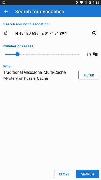
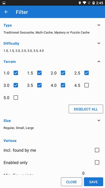
Locus Map nabízí spoustu funkcí a vychytávek pro hráče geocachingu, řečené “kačery”. Donedávna až na jednu – možnost vyhledávat a stahovat kešky z webu Geocaching.com. Tu jsme doposud nechávali na doplňku Geocaching4Locus, který pochází z dílny jiného vývojáře. Doplněk však nebyl již několik let aktualizovaný, a tak jsme se v zájmu zachování dostupnosti a větší flexibility rozhodli funkci přidat přímo do aplikace.
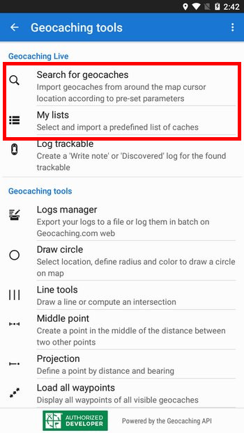
Najdete ji v sekci Nástroje pro geocaching v seznamu všech funkcí appky. Zatím neumí vše, co G4L – chybí live mapa se streamovaným stahováním kešek na mapu a vyhledávání podle GC kódu. To vše ale máme v plánu zanedlouho do Locusu přidat. Než se tak stane, můžete bez obav nadále využívat doplněk G4L.
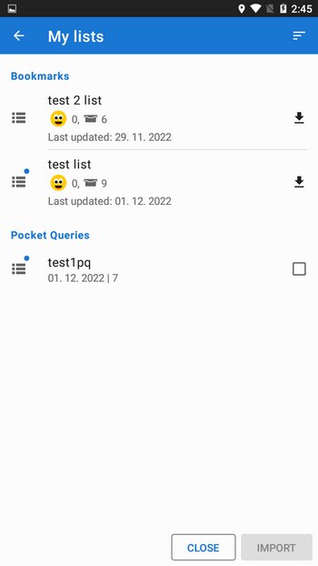
Přednastavené seznamy
Další novinkou převzatou z add-onu je možnost zobrazení seznamů keší, které si předtím nadefinujete na webu geocaching.com. Klepnutím na Moje seznamy uvidíte své seznamy v aplikaci. Na konci řádku pak je tlačítko pro dávkové stáhnutí všech keší v seznamu přímo do aplikace pro použití offline. Ve stejné sekci jsou zobrazeny i vaše Pocket Querries.
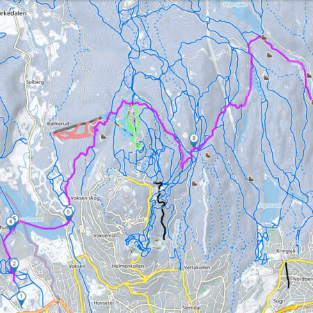
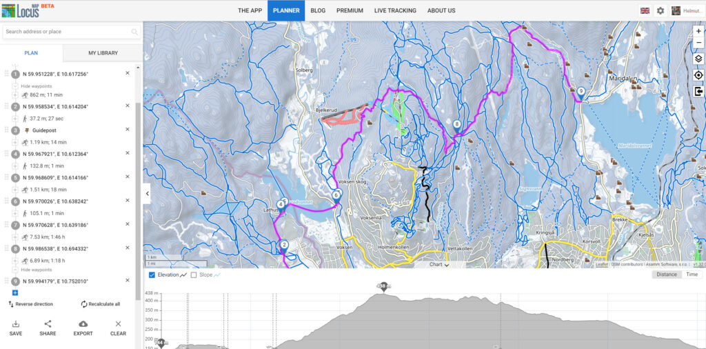
Plánujte výlety na běžkách
Zhruba před měsícem jsme do aplikace i na web umístili zbrusu novou zimní LoMapu. Učesali jsme její vzhled, vylepšili čitelnost, doplnili zimní LoPointy, a tak je připravena na nadcházející sezónu. Zobrazuje sjezdovky podle obtížnosti, a také běžkařské trasy rozdělené do několika úrovní. Samozřejmě vleky, lanovky, lyžařské chaty, bufety, atd, vše tam najdete.
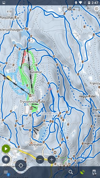
K mapě nyní přidáváme běžkařský profil do plánovače. Najdete jej jak v online LoRouteru v aplikaci a na webu, tak v jeho offline verzi – zde je potřeba pouze aktualizovat routovací data (pokud se vám už nezaktualizovala automaticky). Profil plánuje výlety jak po upravených, tak po neupravených stopách, pokud jsou zaneseny do mapy. Úseky trasy, na nichž není zakreslena lyžařská stopa, je potřeba vykreslit jiným profilem, třeba pěším. Jedná se většinou o silnice, parkoviště nebo jiná podobná místa, která přerušují lyžařskou trasu.
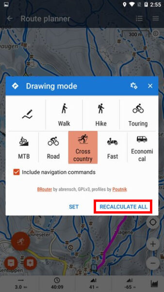
Něco pro pohodlnější ovládání
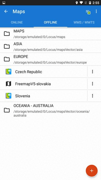
A nyní pár drobnůstek z naší oblíbené sekce kultivace. Začneme v mapovém manažeru, kde jsme sjednotili nabídku pro přidávání nových map. Když nyní klepnete na tlačítko + v online nebo offline záložce, zobrazí se vám stejné menu a můžete přidat jakou mapu chcete, dokonce i zdroj WMS z naší knihovny.
Možnost pro přepočet kompletní trasy pro jinou aktivitu jsme přesunuli z nabídky v horní liště více “na oči” – přímo do dialogu s výběrem profilů. Například máte trasu pro turistiku a chcete ji změnit na horské kolo. Otevřete ji v plánovači, zvolíte profil MTB a klepnete na “přepočítat vše” – na svém místě zůstanou jen tvarovací a průjezdné body.
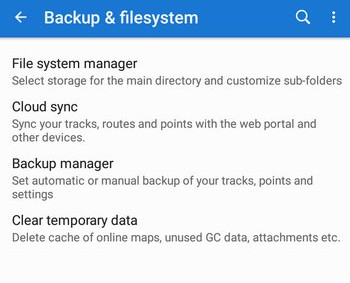
Dost často jsme vám museli vysvětlovat, kde je nyní schované zálohování, kde najdete možnost odpojit data aplikace pro jejich přesun na nový telefon atd. Už nás to nebavilo, a tak jsme to zásadně zjednodušili – všechna nastavení týkající se práce s daty aplikace nyní najdete v samostatné kategorii nastavení Zálohování a systém souborů.
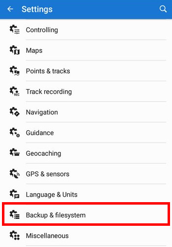
Ta obsahuje Správce systému souborů, kde můžete nastavovat hlavní a pomocné adresáře, správu synchronizace s cloudem, již zmíněné zálohování, a také jsme sem přesunuli výmaz dočasných dat.
V rámci kultivace samozřejmě najdete spoustu dalších úprav napříč appkou, ale o těch už psát nebudeme. Pokud vás některá zaujme, dejte nám vědět v komentářích.
běžkyLocus MapLoMapsLoRoutermapsnew releasewinter


63 Comments
Danke an das Lokus-Team! Die beste App zum Wandern!
Thanks but it's Locus :) I think "lokus" means something quite different in German :))
What do you mean? It's latin: "der Ort". That it's used for the loo comes from "locus neccessitatis".
In Latin, it's Locus with "C" and means "place, location". German "loo" is written with "K" as "lokus", isn't it?
Michael, you are totally rught with your Definition... ;-) the german lokus is also a Place... to shi... :D
You all...enjoy the Advent season stay healthy and have a merry XMas!
Aleluja, a co tak spojazdnit staré trasy, co sa premenili na body. Alebo zlepsit zalohovanie tras aby sa mi záhadne pri kazdej aktualizacie nejake nepostracali...
The backup feature is very good, but I would appriciate if settings would be automatically synced to my locus account.
Hi, the synchronization is dedicated to the tracks, routes and points only because such data can be shared among many devices with Locus. Each device can use different settings because each is used for a different purpose - e.g. a small rugged phone for your bike, or a big-screen tablet for planning routes at home. You don't want all your devices to have the same settings.
Well done!
Thanks!
Hallo ich verwende locus map auf meinem Samsung Handy dabei wird die Höhe beim courser angezeigt das ist super
Aber bei meiner samsung galayx pro watch funktioniert die Karte perfekt aber die Höhe beim courser fehlt, ist das Absicht oder???
Danke für eine Info Gruß Mario
Hi Mario,
go to settings > maps > auxiliary graphics > dynamic elevation > turn it ON.
Danke, hört sich sehr gut an. Werde die neuen Funktionen, vor allem das Geocaching Tool, bei nächster Gelegenheit ausprobieren.
Does the feature already exist and I just haven't found it: If I display the map in the direction of movement (and not north), the map shakes with every step. Can this movement be dampened a bit and if so, where can I adjust it? Thanks for your good work
Achim
try this: 1) calibrate your phone compass https://docs.locusmap.app/doku.php?id=manual:faq:how_to_calibrate_compass, 2) set GPS preference in compass rotation https://docs.locusmap.app/doku.php?id=manual:user_guide:settings:gps#map_rotation_mode, 3) switch to compatibility mode (if nothing else helps) https://docs.locusmap.app/doku.php?id=manual:user_guide:settings:gps#compatibility_mode
What happened to "Load Pocket Queries"? It's missing from the first screenshot.
I need that feature.
I see it now, hidden. May I suggest a title of "Import Lists / Pocket Queries" since they are distinct things? (It would also start with a verb for consistency with the others.)
Yes, will be done.
It's included in the "My lists" feature
Die Geocachedetailseiten sind in LM4 ein Greuel und wirklich abschreckend für einen Pro User. Es sollte besser daran gearbeitet werden als an Funktionen die heute ein Plugin ausreichend gut zur Verfügung stellt.
Ein Abo das sich wirklich lohnt. Es gibt keine bessere App, sich unterwegs zu orientieren, die Tour zu tracken.
when will there be a french version ?
The app is available in 30 languages including French. If your phone system is French, set the app to "default system" in settings > Languages & Units > App language.
Thanks a lot for this post. It explained a few details that were only "hinted" at in the release notes, but had insufficient detail to really know how to take advantage of the change.
Cool, but please finally add ability to buy pro without Google!!
Hi Chris, we are preparing our own payment platform for one-time purchases of Locus Map 4 Premium. It's being tested these days.
+1
I really like Locus Maps, but have an Android phone without Google services.
It is possible now to get Locus Map 4 without Google - download it from https://bit.ly/lmVersions and if you want to upgrade to Premium, buy a voucher at https://www.locusmap.app/premium/#purchase-voucher.
Thanks a lot. Locus ist indeed my favorite app and I'm happy you're working so hard on it.
Thanks!
Thanks Stephan!
Hallo. Alles wie super wieder geworden. Danke vielmals. ABER da ich zu fuss und mit diversen Fahrzeugen unterwegs bin, würde ich mich freuen ihr würdet dem Aktivitäts Profil mal ein Wohnmobil Symbol hinzufügen...oder das Lastauto in Wohnmobil umbenennen. LG Stefan
Hi, we'll do it when we have a stronger demand for it. So far, you are the only one :)
Nein, er ist nicht der einzige!! Auch ich würde mir so ein Profil wünschen. Allerdings habe ich einen Wohnwagen...also bitte ein Wohnwagen-Symbol hinzufügen! :-) :-)
You are awesome! 🙏🏻 🥳
Thanks!
Locus mnie wciągnął, chociaż korzystam jeszcze z kilku aplikacji do przeglądania map podczas planowania wędrówek to jednak Locus najbardziej mi pasuje. Bardzo mnie ucieszyło kiedy uruchomiliście planer internetowy. Czy w przyszłości macie zamiar rozszerzyć o platformę społecznościową, coś na wzór AllTrails, Endomondo, Traseo itp.? Fajnie by było móc tworzyć w LocusMap historie swoich wędrówek i dzielić się z innymi. Pozdrawiam
Thanks, Boguslaw, yes we plan something like this. Not absolutely a social platform but the option to create stories with a collection of tracks and points definitely yes.
Excellent AGAIN Locus Team! really appreciate your hard work, Locus is by far the best app for the Outdoor community!
Thank you Dani!
When will there be an IOS version of Locus Map?
Hopefully we'll release a first beta in the spring 2023
That’s brilliant news! Having happily used Viewranger on various iPhones for years, and then been forced off as a result of the vastly inferior Outdoor Active “upgrade”, this latest update is just what I’ve been waiting for, Michal. Well done!
Can’t wait…
Bisher habe ich meine Langlauftouren über https://www.loipenportal.de/sauerland geplant. Eure App hat mehr Loipen hinterlegt. Da werde ich wohl auf die App umsteigen, die ich sowieso schon seit 4 Jahren für Wandertouren nehme.
Seit ich eure app verwende, suche ich mir Strecken aus, die auf der App gut aussehen (Feld, Wald, Wanderparkplatz, Bushaltestellen, Schutzhütte, Aussichten, Pfade), teste sie, und entscheide, ob ich sie in mein Wanderprogramm aufnehme. Woher kennt der diese Insider-Wege? Tu ich nicht, kennt locus, ich bin es probegewandert. B-)
Grüße von einem skilanglaufenden Wanderführer im Sauerland
Hi Robert,
das Loipenportal wurde zumindest im Südschwarzwald um 2008 in einem Projekt erstellt, aber da das Projekt begrenzte Laufzeit hatte, veralten die Daten leider zunehmend. Locus nutzt OpenStreetMap-Daten, die wie Wikipedia jeder Mensch bearbeiten kann — daher ist auch lokales "Insiderwissen" drin und die Daten werden laufend an die Realität angepasst. Von deinen Hobbys her könnte xctrails.org dir auch gefallen, ein Freizeitprojekt eines Enthusiasten, da findest du auch Bilder zu Loipen, Klettersteigen,... bzw kannst welche hochladen.
Viele Grüße,
Georg
Hi, thanks for the update!
The new app version creates way larger backup files (1 GB vs 200 MB) than before. This makes them harder to handle / upload to cloud storage. The ZIP files now contain a "router" subdirectory which contains the tiles (".rd5") for offline routing. I think it's not worth backing up those tiles, because they can be easily re-downloaded and are out-of-date quickly anyways. Perhaps add an option to disable backing up those files?
Thanks,
Niklas
Hi, sorry for this inconvenience, we've sorted this out. Please wait for a bugfix version.
It works fine now, thanks!!
Good job. Thank you!
I like the new "Recalculate all" button since the first time i saw it there. Good idea.
I am quite happy with this app. One tiny request, though. Without screen lock it happened that I excidently stopped and deleted a whole track recording. But the screenlock as it is now, does not allow moving or zooming the map, which complicates one hand handling. Could you consider to include an optional just move/zoom option into the screenlock?
Hi Steffen, any changes in the app require collective testing and wide demand from the users. You are the only one with such a request so far.
Very good.
The news to Geocaches are really nice and i hope the new features are comming soon.
If Locus want to create some routing profiles for mortorcycles? For Routes with more curves?
Hi, I just got this new version, and noticed, that, each time the screen was locked by the system, I now have to unlock it again to be able to see the Locus Map screen. In former versions there was a setting, which allowed to see and control Locus Map without the need to unlock the screen. On a cycling tour this was a very useful feature, because I could look onto the map during the ride (without stopping) after switching on the display. Now I have to stop, switch on the display, take off a glove (now in the winter) and unlock the screen, before being able to look onto the map. Is it possible to get back the former behaviour in any way?
Hi, the option is still there, in the same place - in settings > controlling > display > unlocks the screen - turn it ON.
There now SILVER is labeled. But I'm using the free version. Obviously I now have to think of buying the SILVER abo. Bummer!
I just bought the SILVER abo, and now the unlock screen feature works again for me. Since I use Locus very often, that's ok for me.
Thank you!
Hallo an das Entwicklerteam :)
Nun, ich werde mir Locus ganz sicher auf mein Tablet als Navigationsgrundlage installieren.
Ich schwanke noch zwischen Locus 3 Classic und Locus 4 Silber.
Und ja, für Aktivitäten hätte ich auch gern das Symbol eines Wohnmobils. Ganz klar.
Sehr viele, die sich bislang nur nicht gemeldet haben würden sich damit sehr deutlich angesprochen fühlen :)
Kann ich davon ausgehen, dass Locus 4 Silver auch über eine Funktion verfügt, mit der ich den tableteigenen GPS-Empfänger ausschalten bzw. dem externen GPS-Empfänger den Vorrang geben kann (wie bei Locus Map Pro)?
Und gibt es bei Locus 4 Silver auch die Darstellung einer Luftlinie als Zielführungslinie zwischen Standort und Zielpunkt (ebenfalls wie bei Locus Map Pro)?
Beides wäre für mich sehr wichtig - als 4x4 Fahrer und Wanderer.
Vielen Dank für die Antwort und alles Gute für das neue Jahr.
Olaf
Hi Olaf, Premium Silver has the same features as Locus Map Classic + some more, see https://www.locusmap.app/silver-or-pro-take-a-look-at-the-differences/. Thank you for your wishes!
Aplikacja Locus 4 jest zbyt rozbudowana...
Hi, what exactly is too complex for you?
Hi guys, I'm in Ireland, and I use LocusMaps a lot when out on the river Shannon and river Erne in my barge, but could do with more detail and a facility to plan routes especially out on the big lakes. Would you consider adding the "handrail" navigation routes from the charts to your maps, showing the safe passages to the various harbours. This would be of great benefit in the event of fog or a rain squall catching me out.
Regards, Phil.
Hi Phil,
I'm afraid our app is focused mainly on hikers, bikers, runners and other "dry-land" outdoor activities. Nevertheless, it is possible to use various custom maps in it so if you come across some map that is in a supported format, that would be the solution for you. More about external maps: https://docs.locusmap.app/doku.php?id=manual:user_guide:maps_external