Die neue Version Ihrer Lieblings-Navigations-App bringt erneut einige wesentliche Verbesserungen. Die meisten Änderungen wurden an LoRouter der App vorgenommen, dem „Generator“ für die Routenplanung und direkte Navigation zum Ziel. Wir haben endlich das Locus Map Projekt für Garmin-Geräte wiederbelebt und obwohl es bereits Herbst ist und die Schwalben schon lange weggeflogen sind, haben wir die erste im Bereich der E-Bike-Unterstützung.
Warnung!
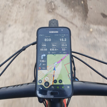
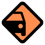
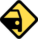
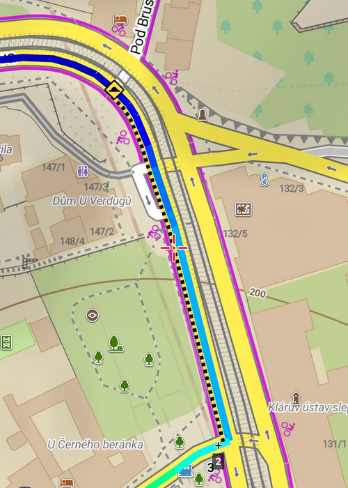
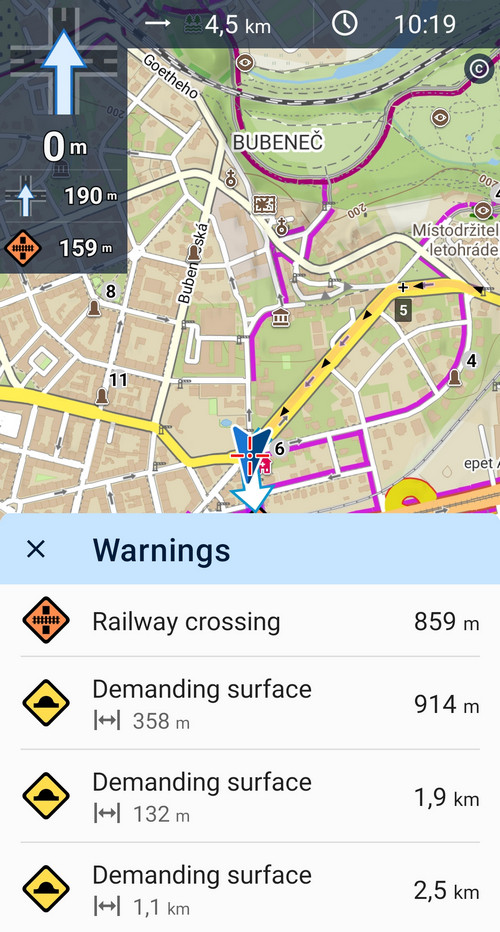
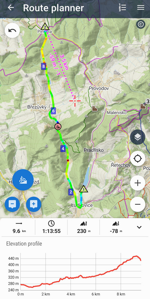
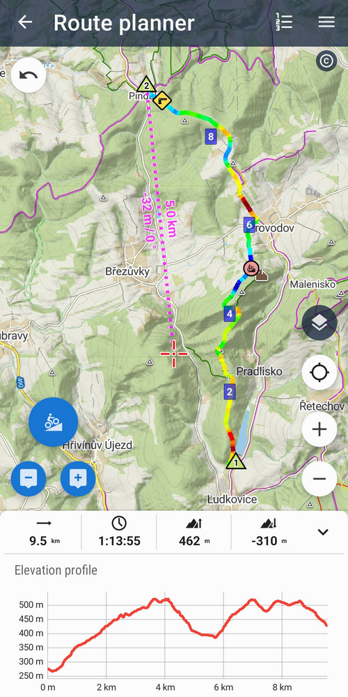
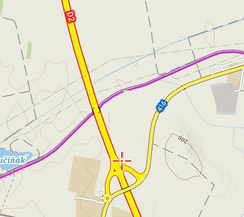
Nein, das war nicht als Clickbait gedacht (hahaha). Nehmen Sie es eher als freudigen Ausruf – ja, der Online-LoRouter in der App kann nun Warnungen für verschiedene Fallstricke auf der Route generieren – für anspruchsvolles Gelände, starken Verkehr, Barrieren, Tunnel, ungeschützte Bahnübergänge usw. Und das sowohl im Routenplaner als auch in der schnellen Routenberechnung für die direkte Navigation zum Ziel.
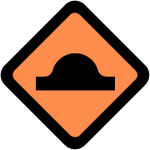
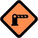
Einige Warnungen haben drei farblich differenzierte Stufen – von der geringsten bis zur ernstesten Warnung:
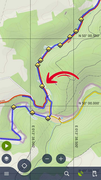
Wenn eine Warnung ganze Abschnitte der Route betrifft, z.B. anspruchsvolle Oberflächen oder starken Straßenverkehr, hat sie auch eine zonale Variante, sodass Sie genau wissen, auf welchem Teil der Route Sie vorsichtig sein müssen.
Die Grade und Arten der Warnungen hängen von der gewählten Aktivität oder dem Fahrzeug ab, das Sie auf der Route verwenden möchten. Wenn die Route über Kopfsteinpflaster führt, ist das kein Problem, wenn Sie zu Fuß oder mit dem Fahrrad unterwegs sind. Es ist schlimmer auf einem Rennrad, und in einem solchen Fall wird Locus Map eine Warnung anzeigen.

Beispielsweise ist eine Route durch das Zentrum von Prag voll von solchen Warnungen.
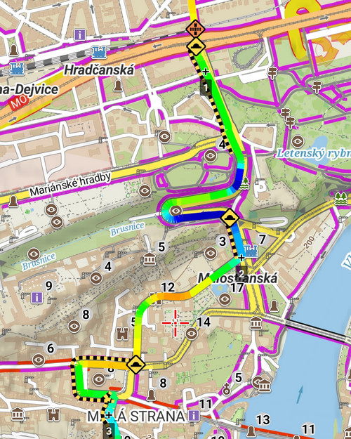
Warnungen werden in der Regel auf der Route auf der Karte angezeigt. Während der Navigation entlang der Route erscheinen die Symbole auch unter dem Haupt-Navigationsfenster.
Wenn Sie auf ein beliebiges Warnsymbol auf der Karte tippen, öffnet sich eine Liste aller Warnungen auf der Route, sortiert nach Entfernung. Die Länge wird auch für zonale Abschnitte angezeigt. Durch Tippen zentrieren Sie den ausgewählten Ort oder Abschnitt auf der Karte.
Das Warnsystem ist bisher nur in der App verfügbar – natürlich wird es mit der Zeit auch auf unserem Web-Planer verfügbar sein. Wir glauben, dass es erheblich dazu beitragen wird, den Komfort bei der Planung Ihrer Outdoor-Aktivitäten zu erhöhen, sowie die Sicherheit bei deren Betrieb zu erhöhen. Zum Beispiel wissen Sie dank Locus Map bereits, dass dieser Abschnitt Gummistiefel erfordern wird… 🙂
Haben Sie Tipps, vor was Sie sonst noch gewarnt werden möchten, wenn Sie Ihre Route planen? Lassen Sie es uns in den Kommentaren wissen!
Ich möchte mein eigenes Routing-Profil!
Ja, wir wissen, dass viele von Ihnen diese Option heimlich (einige sehr laut) wünschen, aber momentan können wir Ihnen eine solche Variante nicht anbieten. Mit neuen Anpassungsoptionen für bestehende Profile sind wir jedoch viel weiter.
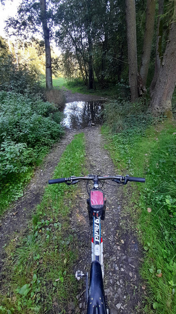
Zuerst und vor allem haben wir den Online-LoRouter mit Schaltern bereichert, an die Sie bereits von seiner Offline-Variante gewöhnt sind. Für Auto-Profile handelt es sich um Standardoptionen, um Mautstellen, Autobahnen oder unbefestigte Straßen wegzulassen. Für Walking-Profile und Trekkingräder wurde ein „Nassbedingungen“-Parameter hinzugefügt, der die Routenauswahl mehr auf asphaltierte Oberflächen mit einem kleineren Risiko von Schlamm anpasst.
Die meisten Änderungen wurden am MTB-Profil vorgenommen. Hier hatte unser Routing-Guru Radim endlich Spaß und erstellte einen anspruchsvollen Algorithmus für die Routenberechnung basierend auf der Auswahl des Schwierigkeitsgrades des Geländes.
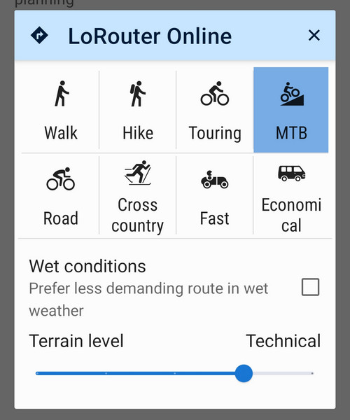
Es gibt fünf Stufen, und sie spiegeln sowohl die Oberflächen von Straßen, Wegen und Fußwegen, als auch ihre Steigung, Höhe und andere Eigenschaften wider. Wenn Sie also die niedrigste Stufe wählen, wird Ihnen Locus Map den sanftesten Fortschritt mit dem sanftesten verfügbaren Aufstieg bieten.
Die schwierigste Stufe wird dagegen eine Linie mit einer gehörigen Dosis Adrenalin austeilen, bei der Sie wirklich alles geben werden.
Obwohl die genannten Änderungen die Online-Variante von LoRouter betreffen, arbeiten wir bereits hart an ihrer Einführung in die Offline-Version – es liegt wirklich viel Arbeit vor uns und wir haben die „Experimentier“-Ebene in der Router-Entwicklung noch nicht verlassen. Wie auch immer, wenn Sie spezielle Wünsche bezüglich der Anpassung haben, lassen Sie es uns wissen.
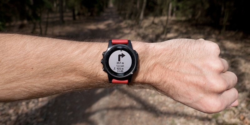
Garmin Add-on für Locus Map lebt!
Und nun eine fantastische Nachricht für alle Besitzer dieser geliebten robusten Uhren. Trotz aller Widrigkeiten, die Garmin ständig auf unabhängige Entwickler wirft, hat unser Kollege Honza ein beachtliches Kunststück vollbracht – er hat das Add-on für die neuesten Modelle operationalisiert. Weitere Details werden vom Schöpfer selbst enthüllt:
„Die bestehende Funktionalität des Add-ons ist vorerst „gerettet“, sodass wir die Kompatibilität mit Geräten weiterhin erweitern oder es weiterentwickeln können. Leider ist die Funktion des Streamings von Karten vom Telefon zum Uhrendisplay nicht mehr verfügbar und kann nach unvorhergesehenen Einschränkungen durch Garmin aus technischen Gründen nicht mehr angeboten werden. Andere Funktionen stehen jedoch weiterhin zur Verfügung, einschließlich „1-Klick“-Routenexport zu unterstützten Uhren.
Dies hat mir einen neuen Anstoß gegeben, über die Integration mit Garmin-Produkten nachzudenken, und ich hoffe, dass wir Sie in Zukunft angenehm überraschen können. Zum Beispiel sind wir uns des Mangels an der Möglichkeit bewusst, Routen mit Locus Map einfach auf Garmin Edge Fahrradcomputer zu exportieren, aber dazu nächstes Mal mehr.“
Die erste Herbstschwalbe – Integration mit Specialized E-Bikes
Nein, wir sind nicht verrückt geworden, wir haben tatsächlich gerade die erste Schwalbe im Bereich der Kommunikation von Locus mit E-Bikes gestartet.
Im Testlauf starten wir die Unterstützung für ein wirklich schickes E-Bike – das vollgefederte Specialized Turbo Levo, mit dem wir zuerst die Möglichkeiten der Verbindung der Fahrradsoftware mit unserer Anwendung über die bisher unterstützten Sensoren für Geschwindigkeit und Trittfrequenz oder Leistung getestet haben… Der neue Sensor liest nicht nur die bereits erwähnten Informationen vom Fahrrad, sondern fügt auch Daten über den derzeit ausgewählten Unterstützungsmodus des E-Bikes und den Status seines Akkus hinzu. Wir können all dies zu unserem Dashboard hinzufügen und es ständig im Blick behalten, wenn wir mit Locus Map auf dem Lenker fahren!
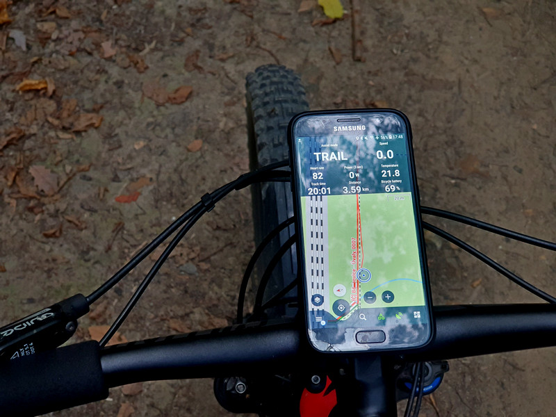
Der Sensor sollte mit den meisten Specialized E-Bikes, einschließlich Rennrädern, funktionieren, aber vorerst werden die Namen der Unterstützungen so angezeigt, wie sie auf ihren Mountainbikes genannt werden. Wir werden dies weiter anpassen, je nach Interesse.
Neuigkeiten in LoMaps
Das Wander-/Fahrrad-Thema unserer Offline-LoMaps hat in den letzten Monaten viele Verbesserungen erhalten, von denen wir besonders gerne hervorheben:
- die Rückkehr der Straßennummerierung – wir haben ein hartnäckiges technisches Rätsel gelöst und vor allem Fernradfahrer werden die Straßennummern auf der Karte wieder zu schätzen wissen
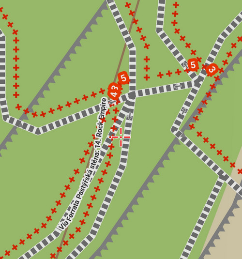
- Markierung von Ferratas – Adrenalinliebhaber werden auf der Karte deutlich sichtbare herausfordernde Berg-, eisenbesicherte Wege (also Ferratas) begrüßen. Und bald auch mit Schwierigkeitsmarkierung!
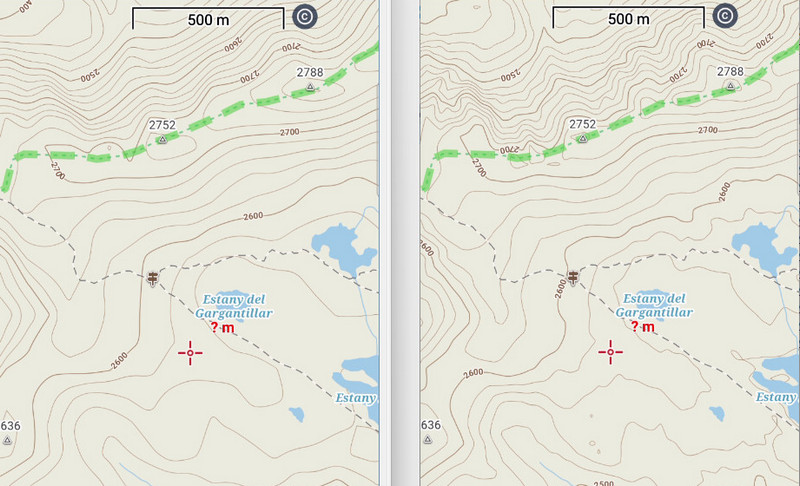
- genauere Höhenlinien – in den neuen LoMaps generieren wir detaillierter gezeichnete Höhenlinien aus 1“ Höhendaten, während wir das Volumen der Kartendateien beibehalten. Wir haben Europa bisher abgeschlossen, aber die Maschinen laufen auf Hochtouren, sodass Sie sich bald auf weitere Ergänzungen freuen können.
Und endlich, auf wiedersehen, Munzee…
Leider müssen wir nach acht Jahren Abschied nehmen von diesem interessanten Outdoor-Spiel. Seine Schöpfer haben den Betrieb der API eingestellt, wodurch die Möglichkeit für das Spiel ausgeschlossen wurde, unabhängige Anwendungen zu entwickeln. Daher haben wir auch die Unterstützung des Munzee-Add-ons für Locus Map beendet und es aus dem Google Play entfernt.
androidcustomizatione-bikeGarminLoRouternew releaseroutingSpecializedwarnung


68 Comments
Was ich seit langem sehr vermisse und mich wundere, dass es noch nicht implementiert wurde, ist, auf einer geplanten Route die Entfernungsmessung zu einem beliebigen Punkt auf dieser Route vorzunehmen. Soweit ich sehe, ist nur die Entfernung per Luftlinie messbar. Oder übersehe ich hier eine einfache Möglichkeit für unterwegs, wie dies zu bewerkstelligen ist?
Hi Fabian, if you mean on a saved route that was planned, yes, that option is available. See https://docs.locusmap.app/doku.php?id=manual:user_guide:tracks:about#trackpoint_detail. If you mean directly in the route planner, there is only beeline measuring available.
Wow what great news from you!
Your software is by far the most sophisticated and most powerful on the Android Market.
Thanks for your great effort, Tom
Thanks Tom, we'll go on trying to do our best :)
Great enhancements!
Thanks Tibor, enjoy!
Thank you I like the new features. Good work!
Thanks Edgar for your kind words! We'll keep on rolling.
There are news for Bosch ebike integration?
Hi, so far, unfortunately, no news. The company doesn't reply to our attepts of contact.
Es freut mich, dass sich meine tatsächliche Lieblingsapp so weiterentwickelt. Was ich allerdings schmerzlich vermisse: Mit Umstellung auf das Abo-Modell wurde für den Gold-Status versprochen für das Offline-Lo-Routing die Möglichkeit zur Generierung alternativer Tracks bereitzustellen. BrouterWeb kann das (soweit ich weiß beruht Lorouter auf Brouter) und es ist insbesondere auf der Langstrecke (50 - 100 km) Gold wert ohne Änderung von Fahrzeug, Wetterbedingung oder Techniklevel alternative Strecken angezeigt zu bekommen, die oft ganz andere Bereiche durchqueren. So kann man sich dann die jeweils am attraktivsten erscheinende raussuchen und weiter ausarbeiten. Denn DIE ALLERBESTE Route gab es noch nie (und kann es auch nicht geben). Ich hoffe hier sehr, dass dieses alte Versprechen tatsächlich Eingang in den Offline-Lo-Router findet!!! Derzeit nutze ich auf meinen Fernreisen für die erste Grobplanung der Tagesetappen zunächst BrouterWeb, importiere die alternativen Tracks in Locus, entscheide mich für eine der Alternativen und gehe dann mit Lorouter an die Detailplanung.
Hi Helmut,
so far, the multi-route generating is possible with GraphHopper router only (settings > navigation > router > GrapHopper). Nevertheless, multi-routing is on our roadmap also for the offline LoRouter. However, it is not as easy as we imagined and still, there are so many other important tasks ahead... Anyway, we are working hard on continuous improvement of the app so hopefully you'll get what you desire sometime in the future.
Terrain Level: here it would be nice to know which properties result in which level. So you can better estimate what you want. Gradients are not so important for e-bikes. Surface only conditionally, we drive MTB. The biggest influence should be the difficulty of the path. S0-S5 (STS).
But there are also BIO bikers (without motor) who do not consider the slope important. But in any case do not want a path with S3.
Possibly in the future here more settings for the user. Which he can save in different profiles.
DE:
Terrain Level: hier wäre es schön zu wissen welche Eigenschaften welchen Level ergeben. So kann man besser einschätzen was man will. Steigungen sind bei E-Bike nicht so wichtig. Oberfläche nur Bedingt, wir fahren ja MTB. Die größte beeinflussung sollte die schwierigkeit des Weges sein. S0-S5 (STS).
Es gibt aber auch BIO-Biker (ohne Motor) die die Steigung nicht für wichtig halten. Aber auf keinen Fall einen Weg mit S3 wollen.
Eventuell in Zukunft hier noch mehr Einstellungen für den User. Die er sich in verschiedenen Profilen speichern kann.
Hi, firstly, the whole warnings system is now at its beginning - we are collecting feedback and ideas both from our users and also internally. Secondly, we consider the gradient regarding surface obviously very important for any EL/BIO activities outdoors. Otherwise, the rest of your hints can be considered howpefully as easily implementable.
As you did introduce sensor support for e-bikes, you are obviously not any more only targeting bio/muscle bikes. It would be consistent and a big usability step for the existing user base with e-bikes to support e-bikes in routing profiles (one response to your request "if you have any particular wishes regarding the customization, let us know"). This could be as simple as a checkbox "e-bike", similar to wet conditions checkbox.
I am not sure @Freischneider did really mean the slope does not matter to e-bikers or it is due to ambiguity of words Michael and me don't agree. To my experience, the slope in sense https://en.wikipedia.org/wiki/Grade_(slope) still does matter, e.g. I experience around 25° uphill as little fun also with an eMTB as the front wheel leaves the ground frequently (at each bigger step/stone), while elevation meters/gain/loss do not matter for me – a shorter, more direct route requiring 300m more elevantion gain (crossing a mountain range) through the woods is clearly preferred with an eMTB over a flatter but much longer route using streets (sticking in the valleys and driving around the mountain ranges). This is why I did take a few hours to customize an BRouter profile, that works quite well for me, but forcing me to use BRouter instead LoRouter.
Hi Georg, if you have an easy way to share your preferred brouter eBike profile, and If you are willing to do so, I would be interested. I would have a look. Thanks.
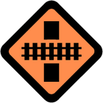
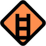
Zu den Gefahrenwarnungen: "Geförderter Weg" verstehe ich nicht, das Symbol erschließt sich mir auch nicht. "Ford" heißt vermutlich "Furt". Was bedeutet "schwerer Verkehr"? Starker Verkehr, d.h. Ihr verarbeitet wie Google die aktuelle Verkehrslage? Das wäre traumhaft. Oder ist LKW-Verkehr gemeint-dann passt das Symbol nicht. Welches ich mir noch wünsche: "Baustelle" für die Autoroute.
Ansonsten hätte ich gern eine Legende für diverse Routenbezeichnungen (Zahlen, Buchstaben, Symbole) der vorgezeichneten Routen.
Hi Stefan, the inaccuracies in the terminology were caused by the AI translation and have been fixed in the article. The sign for "secured section" of a trail depicts a ladder but it can also notify of railings, steps etc. The "heavy traffic" sign warns of possible traffic jams and parts that can be dangerous for selected activity, typically cycling. It is not generated from Google data and is not primarily dedicated to car drivers (as the whole app is not for car driving particularly but for motorless outdoor activities). "Construction sites" do not ususally appear in the map data and we do not have any reliable sourco of such information to display threm among the warnings. The map legend is available both in the app and on the web planner, see https://docs.locusmap.app/doku.php?id=manual:user_guide:mainscr_lpanel&s[]=map%20legend.
Hi Michal,
Mir fallen 2 Warnungen ein, die interessant sein könnten:
* Staatsgrenzen: Glücklicherweise stellen diese in Europa kein Problem mehr da, in anderen Region wäre eine Warnung beim Überschreiten einer Staatsgrenze bzw wenn eine Route über eine Staatsgrenze führt sicher hilfreich.
* Mautstellen/Mautpflichtige Streckenabschnitte: natürlich vor allem für PKW- und Motorrad-Navigation interessant.
Bei den Routingprofilen vermisse ich besonders ein Profil für geländegängige Fahrzeuge. Ich nutze Locus Map auch bei Einsätzen der Bergrettung. Ein Routingprofil für Allradfahrzeuge wäre hier manchmal hilfreich. Zur Zeit nutze ich dafür das MTB-Profil und Ortskenntnis (zur Einschätzung, ob alle Wege auch mit einem Fahrzeug befahrbar sind)
Hi,
- "non-Schengen" state borders and toll gates are marked with the "barrier" sign
- tolled parts of highways are not marked now but you can select to avoid them in the car profile. Nevertheless, we'll consider the option of marking the paid parts.
- offroad vehicle routing - in many countries, especially in Europe, offroad driving is limited, based on local or state regulations. For such cases we would need localized routing data reflecting the measures. Now the router is sourced by OSM data only. Quite a task into the future, though.
Warnings: Some warnings I want to see and some I don't. Can I specify somewhere which ones I don't want to see. Again, it would be nice if you can set it separately in each profile.
DE:
Warnungen: Manche Warnungen möchte ich sehen und manche nicht. Kann ich irgendwo festlegen welche ich nicht sehen will. Auch hier wäre es schön wenn man es in jedem Profil separat festlegen kann.
Hi, warnings and the logic of their display depends on the selected activity. E.g. "demanding surface" displays to road bikers on cobblestones but not to MTB riders.
Herzlichen Dank für all die interessanten Verbesserungen.
Mein Wunsch als Benutzer von Locus-Gold: Da die Strassen-Nummern jetzt vorhanden sind wäre es insbesondere in der Zielführung im Automodus eine riesige Hilfe, wenn diese Strassen-Nummern bei Abzweigungsbefehlen mit angesagt würden, noch schöner wäre das Fernziel, wie bei Tomtom, Garmin und Co.
Hi Reto, as this app is primarily designed and developed for off-road use (hiking, MTBiking, running, geocaching...), we do not plan to add more car-driving features in the near future.
You are awesome!!! Thank you sooo much for your effort 😍🙏🏻
Thanks Johannes a lot!
E-bike:
It is very nice so that it starts here. Do other manufacturers also come ? I ride Shimano EP8 motor. The possibility exists, because the app STRide can also read the data.
https://play.google.com/store/apps/details?id=com.stunlocker.app.ride&hl=de&gl=US
It would be nice to have the ACCU level in % as a dashboard.
DE:
E-Bike:
Es ist sehr schön damit es hier los geht. Kommen andere Hersteller auch ? Ich fahre Shimano EP8 Motor. Die Möglichkeit besteht, denn die App STRide kann die Daten auch auslesen.
https://play.google.com/store/apps/details?id=com.stunlocker.app.ride&hl=de&gl=US
Es wäre schön den AKKU Stand in % als Dashboard zu haben.
Hi, yes, we would like to add also other ebike/motor vendors. But with some, including Shimano and Bosh, no promises, as they seemingly do quite a effort to deny others to utilize their connectivity. Thanks for the link!
Thanks for the update.
But according to my tipical use of Locus map, which is to create routes with the intention of sending it to my Garmin Fenix 7, still are happening the same bugs than with the last version.
1- The locus app is creating points with no elevation value when exporting a route created with locus to fit file. I already documented this issue a lot via email more than a month ago, wich makes the elevation plot and the climb pro completely unusable. I was told this will be fixed on this update. (Super important bug to solve!)
2- The lack of icons for up ahead points (also including turning directions label if possible) (Less important bug in my opinion)
3- The impossibility to sync offline a course with the watch (I know this is not your fault, it's garmin's fault... a pity that this feature is blocked)
Thanks for your time reading my post. I really consider locus the best route planner out there. If you just could solve the bug 1... It would be so great.
Hi Joan, thanks for feedback.
1. will check status of this!
2. yep, we didn't finished it before due to issue with the fact, that various Garmin models have different icon set for this feature and it was really hard to pair it properly. But we are planning another attempt. :)
3. Yep, this is really annoying, mostly because there isn't any technical reason for Garmin to block it. But that just how they manage their software platforms...
Have look at Dwmap in the Connect IQ Store... It does all the thing the Locus add on can't do (stream map to the watch, send a route to the watch for navigation etc).
I export my route to Dwmap and then Sync with the watch. I get navigation, elevation profile and map on the watch
Regarding maps, the difference is that Dwmap stream them from the internet - and that still works. With our maps streaming feature we choose different approach as in the beginning our implementation worked even offline and was able to show also other layers configured in the mobile app. The truth is, that such implementation was really difficult and costs A LOT money on our side. But when Garmin soon after that killed it, we can't justify another such heavy development for such unstable platform. Considering also the fact, that such renderings on Garmin devices are super slow and only partially usable. That is why I definitely don't want to promise it will return is any form on our app, although never say never..
As for the standalone navigation capability, it is still addon to the Locus Map app, we don't want to build "separate" app, so we rely on navigation capabilities of compatible device if user don't want to use Locus Map during the trip. So for this, we have there that easy import solution. Or you can of course use dwmap in such cases after importing there route from Locus Map. Our priority here is seamless integration with Garmin devices, not alter their default capabilities. It is no longer true, that most users of our Garmin app have devices without support of navigation capabilities.
Poprosim pridat aj znacenie trailov a ich obtiaznosti. Casto krat ich nezbadam (az po velkom zoome) a zbytocne ich obchadzam po cyklotrase pritom v podkladoch su uvedene a radsej by som si ich uzil.
Dobrý den, barvy trailů nás čekají, musíme technicky dořešit jejich značení v mapě, aby nekolidovaly se značením turistických tras, které je ve střední Evropě různobarevné. Ale každopádně s ním počítáme.
For the Garmin add on, it is a pitty that the map cannot be streamed to the watch.
Turning off data doesn't work for me as I often use Garmin Live track on long hike.
For that reason, I no longer use locus to track my hike but now use dwmap instead so that I get the navigation direction AND the map streaming from the phone to the watch... I can leave my phone in my backpack and only use Dwmap on my watch (the excellent venu 2 plus).
Please see my other reply to this topic above.
How do I connect Locus to my Specialized ebike? I've found the menu item in the sensors manager but my bike is not showing up. It connects fine with the Mission Control app. Do I have to "Unregister" the bike from the Mission Control app? Should I force the bike to go to pairing mode? If so how? Thanks!
Hi, in case the bike is connected via bluetooth to something else, including other app in the phone, it will not appear in the list of available sensors. You don't need to put bike to any pairing mode. So please make first sure, that the connectivity with the bike is not already "occupied". Then you should see it in the list and be able to add it as sensor. If it is not the case, please write us to helpdesk, we will be able to go deeper to the problem here to resolve it.
Is an add on for android watches, e.g. with wear 3/4, planned?
Hi Alex, it is already available, see https://play.google.com/store/apps/details?id=com.asamm.locus.addon.wear
Would you be able to warn about rock falling or avalanche risk?
Hi Fernando, all information on LoMaps or routes generated by LoRouter is sourced from OpenStreetMap. We'll explore these options when we get more feedback.
Hello,
I have to honestly admit that all the "warnings" bother me and the tracks on the map become very confusing. Is there a way to disable the warnings? I tried but didn't find this option. That would be great! I just don't need the warnings. Best regards :-)
Hi, the whole warnings system is now at its beginning – we are collecting feedback and ideas both from our users and also internally. So far, you are only one of two users who wants it removed :). Anyway, the system will be further optimized.
Ich bin vor Jahren von Orux-Maps umgestiegen und derweils auch Gold Nutzer. Ich habe 'früher' hauptsächlich Fusswege oder Radtouren getrackt ... dann auch irgendwann Motorradtouren geplant - gerne auch im Web dank Gold. Nun besitzen wir ein Wohnmobil, ich plane noch immer damit, muss aber immer mit dem Autoeigenen Navi prüfen, ob das Ding daher kann / darf. Eine Art LKW Modus wäre ein echtes Plus (und gegenüber Googl sogar Alleinstellungsmerkmal). Ich habe Sygic ausprobiert (7 Tage) ... ist gut aber kein Planungstool.
Wie sieht es aus?
Hi Dieter, as this app is primarily designed and developed for off-road use (hiking, MTBiking, running, geocaching…), we do not plan to add more car-driving features in the near future.
I wanted to ask about the possibility of editing the names of navigation tips. Depending on the language used in the phone, these names are longer or shorter. My language is Polish. So for example direction tips 'turn right' is in the locus 'skręć w prawo'. Since I often export the route to a Garmin device, these names are cuted to eight characters. And on my watch I have the 'skręć w ' tips. Of course, I can edit all these points after creating the route, but it is terribly time-consuming and tedious... Is it possible to edit the localization files of a given language? Even removing the word 'skręć' from all directions would help.
Hi, we would do this if there is wider demand for it. So far, you are the only one. Place this idea on our helpdesk and let other users vote for it. When the idea is greatly supported by others, we'll implement it.
Again a lot of nice new features!
I'm so thrilled to have discovered Locus and I'm enjoying a lot the reliability of the app!
What could be interesting as well is the ability to plan a route ... on the water! I'd love to be able to plan more accurately my packrafting day !
Keep up the good work!
Hi, set BRouter as the default router in Locus settings. If contains a "river" routing profile.
Hi guys, I am also working in IT and I can only give you 3 thumbs up for this excelent Release notes. Very nice writing style and easy to ready. Not just a super dry bullet list of new features. One can clearly see thehow much effort you put into this and it was worth it. Also your app ui is, considering the amount of features, very clean and everything is at the right place. Keep on rocking!
Hallo, für Euch nur mal zur Info. Outdooractive (zukünftig auch Komoot) arbeiten seit geraumer Zeit mit den Nationalen Naturlandschaften (Nationalparks, Biosphärenreservate etc.) in Deutschland zusammen (https://nationale-naturlandschaften.de/). Vielleicht wäre eine Kooperation auch etwas für Euch? Hierbei wird bspw. angezeigt, sobald man ein Schutzgebiet betritt od. eine Route plant und welche Verbote/Gebote in den jeweiligen Schutzgebieten existieren oder welche Wege zur Zeit gesperrt sind. So weiß man was in den Gebieten zu beachten ist. Bspw. auch relevant für Hundehalter oder wo man auf gar keinen Fall campen darf und mit Bußgeldern rechnen muss etc. ;)
VG
Nice :-)
> Do you have any tips on what else you would like to be warned of when planning your route? Let us know in the comments!
For bike + hike route planning, I'd like the planner to make me aware of very steep sections – which could reuse the same logic as the already desired avalance warning. 3 levels seem appropriate; IMHO bike profiles shall have one threshold around 18° uphill as for steeper sections, the front wheel tends to leave the ground much more often.
For hiking, warnings for sections with high SAC difficulty grades would be nice, so I see a possible connection is having difficult sections. In order for that feature to be really useful, users would need a possibility to configure the "unproblematic grades" for the hiking profile (which relates to your request "particular wishes regarding the customization, let us know.")
I'd like a possibility to configure for each warning category whether yellow, orange, red or none is shown. I am unsure whether I need one configuration per single profile or for a profile group (e.g. all bike profiles) or for all profiles. For example, in profile touring bike, an orange warning appears at each junction with a tram – resulting in a warning every 2-3 meters in some places of my home town. That makes it simply impossible to mentally process each single warning while riding the bike & watching the traffic, and a tram is not _that dangerous_ for a tour bike that a serious warning (=level orange) is required.
Hi Georg,
Very steep sections are something we do consider important. Both for hiking and cycling (road and mtb). Maybe there is even no need for hard-coded limit, very steep sections can be up to some extend detected in the "context" of current route. Also warnings for "problematic surface" should IMO depend on gradient. Steep downhill with fist sized rocks is clearly different from a flat rocky section in the severity of warning.
High SAC difficulty is already implemented.
Railway crossing, hmm, fair point, but the problem is when really dangerous unprotected railway crossings (fast trains) are mapped the same way.
Hi,
- steep sections - you can set up route coloring both for the planner and for saved routes - steep uphils are colored purple, steep downhills are dark blue
- difficult hiking sections - demanding terrain and assisted parts of the trail are already notified
Anyways, thanks for the feedback, we'll consider all of it.
Great news that you have plans to take up work again on the Garmin integration. A nice improvement for the Add-On would be the possibility to start/pause/stop the track recording on the phone from the watch. This would make up at least a little bit for the loss of the map display (which strangely enough still works if the phone is offline, i.e. with wifi and mobile data turned off)
Dzień dobry, dziękuję za nową funkcję. Czy jest możliwość dodania takiej funkcji do routera, aby układał trasę od do z uwzględnieniem stacji benzynowej i sklepów spożywczych / źródeł wody? Wyobrażam sobie, że dla kolarzy mogą to być przydatne punkty na trasie.
Hi, both petrol stations and water sources are on the map as active "LoPoints" and as such they can be easily added to the route.
It would be awesome if Locus could incorporate the "Digitize the planet" API into route planning!
Höhenlinien
Hallo, in dem Beispiel der Höhenlinien sind die Höhen Ziffern da wo es runter geht, auf dem Kopf sprich umgedreht. Das ist super aber auf meiner Karte bleiben die Ziffern immer richtig herum lesbar, so dass ich oft nicht weiß ob es da runter oder hoch geht. Liegt das an den Einstellungen?
Sonst echt toll die App, macht mein Leben schöner, danke
Hi, the contour line numbers are always displayed in the "downhill" direction so that it is clear in which way the slope is placed.
The Lokus 3 usera would have to pay for the upgrade to the Lokus4... That's not so nice imho
Hi, Locus Map 4 is available for free in its basic version. As a user of Locus Map 3 Classic you get a 100% discount on one year of Premium Silver and 50% on Premium Gold.
hello dav, it's not so nice to complain. you can be grateful for an application with a sustainable business model that allows for continued innovation and development. if you don't want to pay, you try something else. good luck finding anything with similar benefits. thank you locusmap for offering such a desired application.
how about motorcycle profiles for riding street and dirt?
Hi, it's similar to the offroad vehicle routing – in many countries, especially in Europe, offroad driving is limited, based on local or state regulations. For such cases we would need localized routing data reflecting the measures. Now the router is sourced by OSM data only. Quite a task into the future, though.
thank you
For those trying our new implementation of Specialized ebike sensor, please note that there is currently bug which might cause crash of the app while connectivity with ebike is active. We have it already fixed in beta versions, but decided to wait for new full release to fix it even in Google Play version.