Během třináctileté historie Locusu jsme se setkali s mnoha zajímavými až bizarními způsoby využití aplikace. Díky své bezbřehé univerzálnosti a nesčetným možnostem nastavení si původní apka pro kačery, turisty a bajkery našla cestu i mezi profíky různých zaměření. Takže například jeden dopravní podnik s Locusem zaměřuje výhybky a rozvodny, správce jednoho ropovodu na Aljašce jej využívá k monitoringu a servisním pracem, někteří řidiči autobusů v Polsku jej využívají pro výuku nováčků, kterým hlásí polohu zastávek… No a dnes o dalších takových raritách napíšeme více.
Pomáhá při ochraně přírody
Tohle využití naší aplikace nás těší asi nejvíc. Již před sedmi lety jsme psali o tom, jak Locus Map využívají ochránci přírody na Nové Kaledonii, kde pomocí něj mapují výskyt některých ohrožených druhů zvířat, například nelétavého ptáka Kagu.
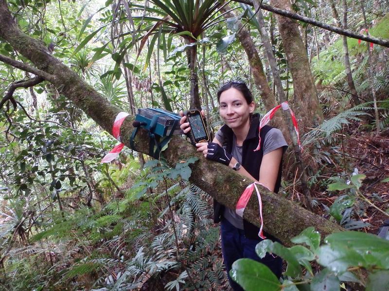
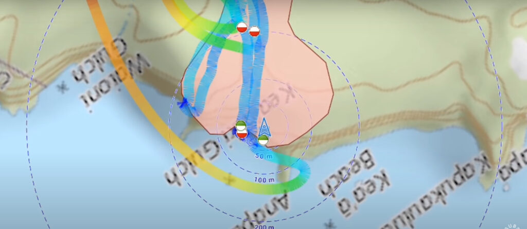
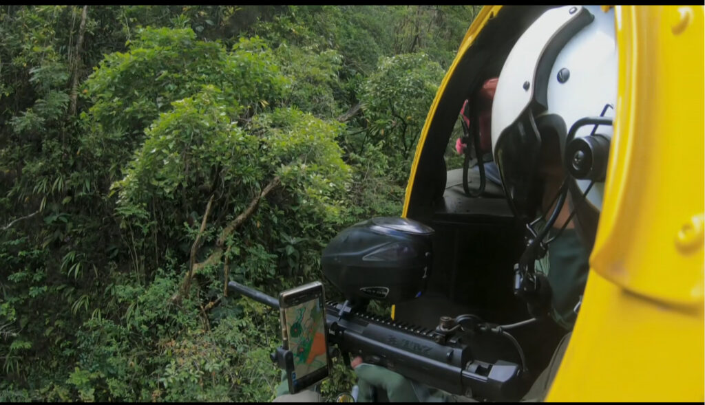
Před třemi lety se Locus Map objevil v dokumentu americké stanice VICE News, který informoval o boji přírodovědců a ochranářů z havajského MISC (Maui Invasive Species Commitee) s invazivním druhem rezavých mravenců. Jejich rychle se rozrůstající kolonie se snaží ochranáři regulovat pomocí postřiků z vrtulníku. Pilota navádí na správné místo právě Locus Map.
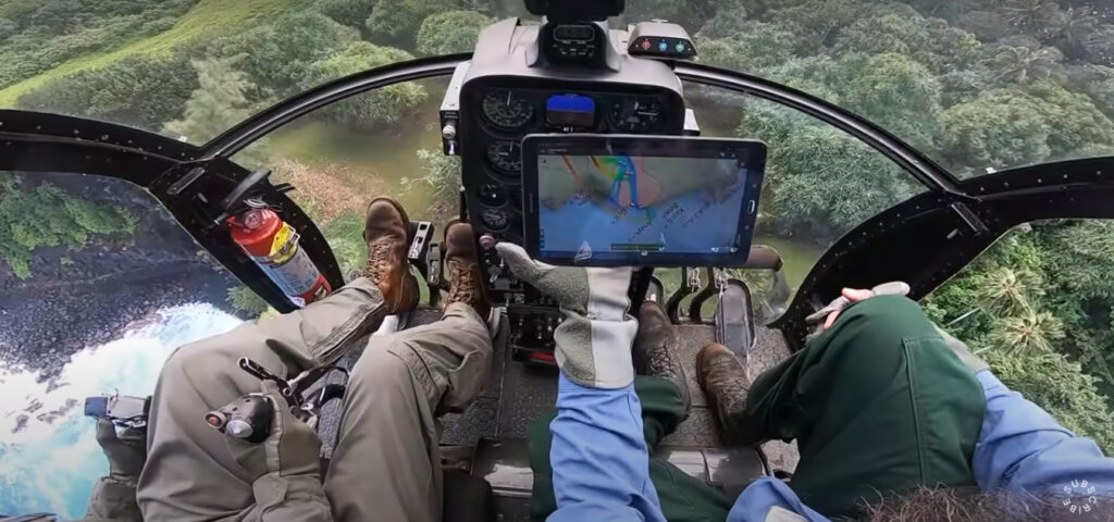
Možnost zákresu zaznamenávané trasy do mapy s “reálnou” šířkou záběru postřikovače umožňuje pilotovi poměrně přesně zacílit svůj let nad kontaminovanou oblastí a pokrýt tak efektivně celé zasažené území.
Stejný tým vědců se objevil vloni i v dokumentárním seriálu BBC Green Planet s Davidem Attenboroughem. Jeho pátý díl “Human Worlds” zobrazuje Locus Map opět “v akci” na vrtulníku, tentokrát při ostřelování invazivních rostlin v džungli na havajském ostrově Maui.
Experti z týmu MISC, kteří mají na starosti data a využití digitálních technologií, si aplikaci nemůžou vynachválit: “Vaše aplikace se nám líbí a již několik let ji používáme ke kontrole invazních druhů. Přizpůsobitelné rozhraní Locusu je opravdu užitečné. Zaznamenáváme trasy, abychom ukázali místa, která zkoumáme, a používáme rychlé body k zákresu míst kontroly invazních druhů. Zde na Havaji jsou i další organizace na ochranu přírody, které používají Locus.”
Z funkcí Locusu si pochvalují také možnost sdílení zálohových souborů, vlastní offline mapy a export/import dat ve formátech GPX a KML. Jejich kolegové využívají Locus Map také na Guamu při mapování invazivního druhu hada “brown tree snake”.
Pomáhá při ochraně životů a majetku
Další velkou skupinu uživatelů máme mezi záchranáři, hasiči a dalšími S&R složkami. Před lety jsme pro ně spustili program podpory, v rámci kterého týmům poskytujeme zdarma licence na Locus Map Premium. Díky tomu Locus Map již používá přes 50 S&R organizací z celého světa.
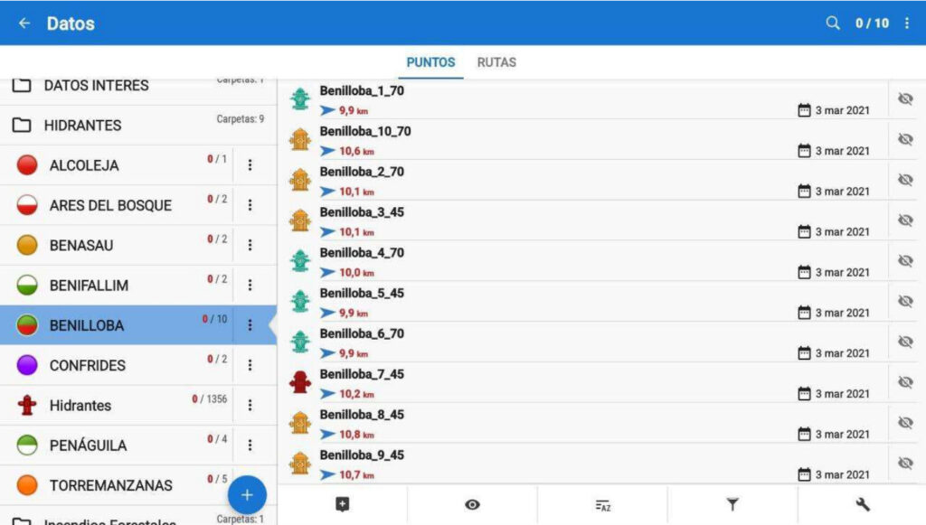
Záchranáři ze španělského SGISE (Societat Valenciana de Gestió Integral de Serveis d’Emergències) vyjmenovávají výhody aplikace pro jejich organizaci: “Jednou z hlavních výhod je, že tato aplikace dokáže používat mapy bez připojení k internetu. Pomocí offline mapové aplikace můžeme zaručit, že všechny jednotky hasičského záchranného sboru mají k dispozici stejné podklady a mapy. Jedním z využití této aplikace je průběžné poskytování informací a dat od jednotek lesních požárů sdílených napříč celou organizací.”
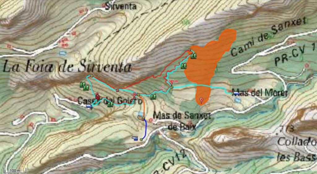
Pomocí Locusu organizace nejen sdílí polohová data zaměřených požárů, ale také buduje databázi hydrantů, lesních přístupových a únikových cest, vodní rezervoáry atd. Pomocí Locusu se také navigují jednotky při pátrání po pohřešovaných osobách.
Pomáhá při vývoji nových technologií
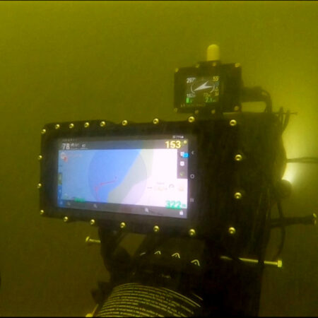
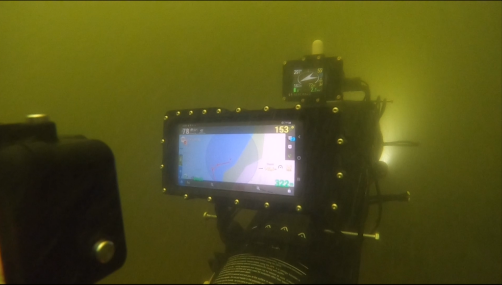
Jako pomyslnou třešničku na dortu si necháváme nakonec opravdu raritní projekt, který by nás nenapadl ani ve snu. S prosbou o součinnost a spolupráci se na nás obrátili designéři a stavitelé podvodních propulzních a navigačních systémů ze společnosti Seacraft.
Jak poznamenává jeden z vývojářů společnosti Seacraft, „orientace pod vodou je obzvláště obtížná kvůli často špatné viditelnosti a nemožnosti proniknout signálům GPS skrz vodní vrstvu. Ještě obtížnější je to při rychlém pohybu, kterého se dosahuje pomocí potápěčských pohonných jednotek. Pro usnadnění této činnosti vytvořila společnost Seacraft speciální podvodní navigační systém založený na principu mrtvého tahu s názvem ENC3, který je komerčně dostupný v několika variantách.
Někdy je však zapotřebí vizuální reference a možnost provádět navigační rozhodnutí v reálném čase. Zde se s určitými úpravami jako podvodní mapový systém osvědčil Locus Map. S pomocí týmu Locusu tak bylo možné rychle vytvořit funkční prototypy usnadňující provoz pod vodou.“
Potápění s mapovým displejem před sebou je čistá radost, nicméně pokud už teď rozbíjíte prasátko, abyste si podobné zařízení koupili, protože na něm funguje vaše oblíbená aplikace, musíme vás prozatím zklamat – zatím není komerčně dostupné.
Hustý, co? Ale nezapomeňte, že tyto extrémní případy jsou možné jen proto, že jsme vyrobili naši outdoorovou navigační aplikaci mnohem flexibilnější, pokud jde o související funkce, přizpůsobení a dostupný obsah, s nímž lze pracovat, takže si ji každý může užívat podle svých představ. Stále se zaměřujeme na naše hlavní aktivity, tedy pěší turistiku a cyklistiku, ale jsme dostatečně univerzální, abychom zvládli i další způsoby, jak se udržitelně pohybovat v přírodě.
ochrana majetkuochrana přírodyochrana života a zdravíS&Rtechnologievývoj


42 Comments
Personally, it is the very first time I have fallen in love with an app. The sensation is so fullfiling. Thanks to the teem to help me enjoy life at such a level...
I use the app on my motorbike for navigation, very fast and accurate. i can share my tracks and poi for my friends with only one program.
at beginning very tricky because the much options to set.
thanks
Great article. I can't imagine it is so elastic.
I'm a cctv and security alarm specialist from Poland. My company is taking care of a security system on a big, closed residential housing estate. We use Locus app for keeping record of camera locations (over 100 places), outside junction and switching boxes (over 70 boxes) as well as the paths of underground installations like copper and fibre cables (over 10km of paths). This app have greatly helped us with collecting and logging the information as well as reduced the time needed for finding fault locations.
We had need for a tool to log locations on map, describe the type of location (icons, photos etc...) and guide a serviceman to a location. I've used Locus for biking and milsim before so using it was my first thought. It was a good decision.
Thank you Locus team for this versatile application :)
We are using the app since 2016 to locate our hiking path in the mountains. From this date we are using it each holiday. It is the most complete app in Google store. Also the helpdesk is quick for answering in case of issues. I recommend it to everyone 👍👍
We are working in conservation, on Colombia, the app is a greit hepful for our personal
I'm waiting for the day where I can buy my first Locus device for navigation! Locus software and a dedicated device - a dream!
There is simply no competitor to this awesome peace of work!
Start crowdfunding for the Locus Navi and you get my money!
This Tom agrees!
We use locus in our company for enviromental survey to write down location of animal tracks or our stuff like bat detectors or harbour porpoise underwater c pods.
Great story!!
Grandi passi nel settore. Ottima app.
Inizialmente la utilizzavo per la mtb.. poi ho iniziato ad usarla, vista la grafica e la possibilità di interagire, anche nel servizio A I.B. (anti incendio boschivo di Regione Lombardia) e ricerca persone di cui faccio parte. Stiamo creando un gruppo di lavoro su cartografia /GPS e la proporrò certamente...
Grazie per il lavoro fatto e per quello che ci aspetta...
Ich bin seit Jahren begeisterter Locus Fan und habe die Silber Edition. Bei den vielen Funktionen muss man sich aber erst einmal intensiv mit allen Einstellungen beschäftigen. Dann gibt es nichts Besseres.
Mich stört nur die Häufigkeit der Routing Ansagen. Bei jedem Querweg kommt die Ansage "folge dem straßenverlauf". Das ist etwas stressig. Es würde ja reichen wenn wirklich nur bei Abbiegungrn eine Ansage kommt.
Das ging mir genauso. Ich liebe Locus und nutze es bestimmt seit über 10 Jahren, aber fürs Navigieren beim Mountainbiken zum Beispiel, habe ich mir noch einen Wahoo zugelegt.
Używam Locusa od lat, jeszcze w czasach gdy nie miałem zegarka rejestrującego ślad, robił to Locus w pokrowcu przyczepionym na przedramieniu z telefonem.
Już wtedy był support dla map TrekBuddy.
Teraz, niezastąpiony w górskich wycieczkach (Słowacja, Polska), już z mapami kupionymi z poziomu Locusa.
Nie wyobrażam sobie życia bez Locusa 😀
A have an M.A. in Geography and find that this little app is very versatile. I downloaded into it all the known archeological sites in my municipality, and known paths, and can add more that had not yet found their way onto base maps. I also enter the location of a wide variety of plants my pharmacist wife is interested in, and those that I am too (edibles).
I have even designed my own symbol library to complement those the app has.
This damn little program is almost a GIS system!
Proficiat!
Wij zijn recreatie e-bikers en we vinden de app super! Ook heel handig om ritten te plannen! Al menige apps gehad maar dit is de beste! Eén tip: het blauwe pijltje (cursor) mag iets vetter gedrukt ....
Interessant verhaal!
Hi Diane, thanks for your feedback! You can enlarge the cursor or use a different cursor in Locus settings > controlling > map screen > map cursors.
I use it also whenever I find mushrooms ! Of course I also add pictures of the biggest 😉
Everything sweet but would be nice to keep support on wearables too - Garmin connectiq app has a bug for over a year now, not to mention no support for devices like Instinct 2X which is basically ver 2 with bigger display...
Hi Lukas, oh, how we like to keep supporting Garmin devices via our dedicated addon, but the team behind Connect IQ platform do their job to destroy whole platform and demotivate all remaining devs pretty well! :( Currently the app can't be even updated to support latest devices like Instinct 2X as they removed support (without any notice in advance) for key method how the app can even run on so much different device models. So the current status is that we are trying to find the best solution how to continue to support the app even in the future, but it may mean its major rework and removing lots of older devices from compatibility list. No clear decision on this yet, but definitely among priorities for us.
Unfortunately Garmin is very bad in providing good software! Have a look at the forums and see how many people have problems.
Locus folks, start a crowd founding for your own device! Pretty sure you will be market leader pretty soon - there's no better peace of work out there!
But hardware gets better and better - battery life of Instinct 2X is awesome so I wanted to use it with Locus - no luck so far but hopefully it'll be fixed - dwmap for example works fine so it's possible
As I go Pacific Crest Trail 2024 with Garmin Fenix 7X and Locus, I am working hard to make sensible symbiosis of those two wonders. So far, I found the best to prepare my day hike at Locus and transfer it to Garmin. What I need walking long distance is not to loose track. Garmin is enough for it. Better handle of waypoints from side of Locus would be great - second next think I need is to know, how far next river crossing or campsite is. To know more details I will switch Locus. I will let you know end of 2024 how it worked😉
If the addon now works for older devices. Then keep it.
Make a new one for newer devices.
I am a wilderness guide and survival instructor, consulting adventure shows from different countries. From few years our crew use only Locus map in the nature, as using very readable Lomaps and giving easy transfer with various formats and apps. Thanks for your great job!
Currently I work as a postman: I deliver Newspapers at night and Mail at daytime in constantly varying districts. Locus Map is the killer app for that purpose, I can mark all the destinations on the map with custom symbols before I start and do not have to memorize hundreds of different names and streets and products.
I only wish there were more and better sorting-options in the POINTS-Folders, if I could sort the points in the folders along streetnames/houseNr. my workflow would be greatly improved.
Thank you so much for this awesome App. Of course I have the Gold-Membership.
Locus Maps is the main reason I haven't switched to iPhone and using Android, because there's no iOS version.
Ich nutzte LocusMaps gern und viel. Geleändeplanung in der Fotografie, Farradtouren, Stadttouren. Ich vermisse die Themes, z.B. Hilo. In der Stadt und Outdoor ist es nett zu wissen, wo ich essen kann. Für mich wäre die Lokalisation von PARKPLÄTZEN ebenso wichtig, ansonsten kann ich die Routenplanung mit dem Auto nicht nutzen. Ich hoffe, diese Funktionen kommen bald. Ansonsten wird das Tool für mich als "Triple User" (Fahrrad, Wandern und Auto) unbrauchbar.
Grüße
Here in Philippines,The Department of Environment and Natural Resources (DENR) also using the app since 2017 in the monitoring of forest plantations, survey and as well as in monitoring of environmental threats. Its advanced features offers a great help to the agency.
I will brimg my bits to this - I use maps from this devoper for maybe three decades (I used Locus precedessor Smartmaps to travel across East Europe). In 2024, Locus will be my main navigation tool on Pacific Crest Trail SouthBound. Just to explain importancy of reliable navigation going from Norh - trail is often hidden under snow, trail markings are mainly oriented for hikers coming from other direction. I don't know better outdoor navigation. And I am proud it comes from my country-Czech Republic. ❤️
bonjour,
je decouvre l'application et j'aimerai vraiment pouvoir l'utiliser ... mais je fais du velo de voyage avec un iphone.
La version ios, c'est prévu, pour bientôt ?
Hi, the first testing version is to be published in a few days but it'll be a very light version with only a few basic features.
The web locus planner fails to load maps properly, though a few days ago it was OK.
Hi, we noticed that yesterday too. Now it is OK. Probably some issue on the server provider's part. Anyway, next time when you encounter any problem with the app or the web, please contact our helpdesk at https://help.locusmap.eu. Thanks.
I have used the Locus Classic app on my smartphone while navigating on inland rivers and lakes. Despite not showing depths or navigation markers it gives me situational awareness when comparing to a paper chart. I find this particularly useful when navigating the Shannon river in flood conditions, where the twists and turns of the river were hidden. By comparing my position on the app screen view of the river course with the marked navigation channel on my paper charts I was able to avoid going off course and risking fouling a submerged fence or ditch, or running aground. It saved the expense of a full GPS marine plotter system which I would otherwise rarely have use for.
That said, it would be great if the app included a waypoint system which allowed for trip planning travelling along waterways instead of roads and tracks, for example to and from harbours on the lakes. Currently it is only possible to do this by following a previous track recording to/from that destination.
Fingers crossed that option might be added.
The app is really phantastic. Currently I'm preparing our sailing trip and also for this purpose Locus helps. Unfortunately the planner on PC doesn't support OpenSeaMap - maybe in next version?
Hi, we do plan adding some more maps on the web planner but not OpenSeaMap... :(
Interesting article. It seems you highlight your app's versatility, yet when I submit bugs related to non-core uses, they get rejected.
For example tracks over the intl date line wrap around the earth. In theory one could user a glider to cross it.
Also, Track lines and cursor course line is straight vs following great circle arc. You claim it would be too difficult to implement even though your Guidance feature already has it implemented.
Hi, yes, we highlight our app's versatility and usability for the purpose it is designed - hiking, biking or geocaching. If you want to discuss over-the-edge possibilities like flying a glider around the globe, please look for some around-the-globe-flying app. Locus Map is not that one.
You illustrate the issue. Any mention of using the app beyond hiking/biking causes the bug/issue/request to be pretty much ignored and misunderstood. I didn't say I'm flying around the globe, I said your app says I do if I cross the date line, which is obviously wrong. I don't think its too much to ask to fix simple bugs or have already implemented features be consistent across the app. Yet this entire article highlights using locus maps beyond the purpose it was designed.
If you have any problem with the app, please visit the helpdesk at help.locusmap.eu where the devs are available for help or advice. The commentary thread under a blogpost is not the right place. Thanks.