Dear Locuser, We’re happy to introduce new version 3.4.0 that is available in your store. What is the hottest new? Probably the pop-up balloons.
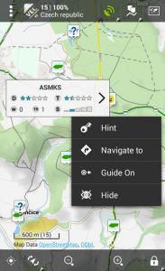
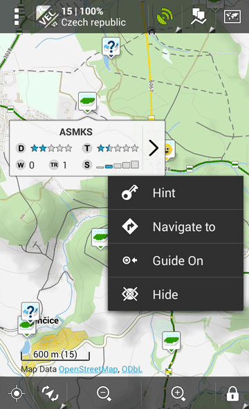
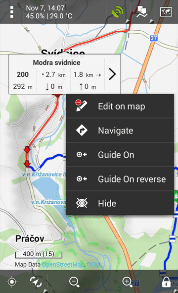
Pop-up labels
New solution brings possibility to work with points or tracks very quickly and directly on the map. It’s very useful, for example for geocaching when you can get important information very quickly for hunting or for navigation. These quick pop-up labels work also with tracks.
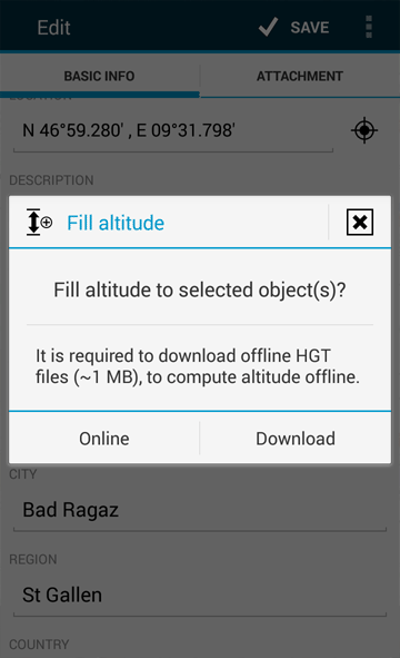
Elevation data
Do you use feature fill altitude? Version 3.4.0 contains new dialogue that automatically uses offline elevation data or download them if data are not available.
Velo Hero
Velo hero it’s beautiful web service where you can maintain your recorded tracks. Locus offers direct export to this service now. Try it.
Clickable MBTmaps
Lastly the last big advance is wide support for MBT – especially UTFgrid feature. It enables to connect tiled map with parametric data. It makes maps more interactive and Locus is ready to show data related with map areas. There are also lots minor improvements – for example, export points into CSV file in custom coordinate system, fixed map rotation during guiding and more.
Enjoy it Your Locus team


10 Comments
Great, this is what I was waiting for for a long time! I wrote a small blog post to highlight this new feature, which makes Locus Pro really stand out from its competitors: http://pvanb.wordpress.com/2014/11/07/locus-map-pro-carries-its-support-for-mbtiles-to-the-next-level/
Thank you for blog post :) We're glad that it's useful for you.
Dear Voldy,
your text contains serveral mistakes. I'd be pleased if you'd publish texts that have been proof read.
Yours,
proof reader
Thank you. Some mistakes were corrected.
Hi Voldy, I really like the pop ups :) but would really love to customize the displayed information (see idea https://help.locusmap.eu/responses/how-to-customize-poi-popup-introduced-in-v340).
How/where can users get MBT maps with UTFgrid features?
Thank you, Georg
Hi Georg,
I agree with menion - not to "over-customize" these pop-up. But let's wait for voting results of your idea :)
Honestly I don't know if there is any storage with MBT clickable maps that would be usefull for hiking/cycling. We extended the MTB map functionality based on request of Australian geologists http://dwh.minerals.nsw.gov.au/CI/warehouse?content=mobileapps
Paulo mentioned some maps in his blogpost (see previous post).
Thank you, Voldy - with both links I got an idea what possibilities MBTiles maps with UTFgrid offer. Very interesting it works.
For pure hiking, cycling etc I don't see "relevant" information that is not addressed via "usual vector maps" (e.g. terrain type, difficulties of ways, barriers, ...) in combination with HTG elevation files (e.g. to auto-fill track elevation profiles) besides such information that is changing too rapidly to be stored as an offline map (like current perception & temperature) but better as a WMS layer.
For more general purposes, UTFgrid could be a big step towards an Offline POI database (see http://forum.locusmap.eu/index.php?topic=3267.90): If a UTFgrid-enabled map was used as a map overlay, so over the vector map, it could show POI data as popup upon a tap, that is elsewise "locked away" within the mapsforge files - e.g. the phone number of a hut, opening hours of a supermarket, grades & routes & stone of a climbing spot. To me, it seems to be a very quick & easy yet clean way to make POI data accessible offline, because Locus seems to already have all required functionality - all we need is a transparent MBTile map with POI-info as UTFgrid. Further discussion of this approach in the forum tread :-)
Cheers, Georg
안녕하세요
지도가 빈약해서 지도 역할을 못하는 것이
각각 나라 지도를 볼 수 있게 해 주시면
좋겠네요
@Georg That should be feasible; creating a transparent mbtiles layer is easy enough in Tilemil. But the interactive element of a mbtiles only works as normal layer (I think), so you could just just a mbtiles layer as base layer and overlay it with any layer you want to use with full opacity.
@Paulo: Thanks for the information - let's see what happens :)