End of May is here and together with that new Locus version. It comes with package of improvements with goal to increase Locus capabilities. Let’s put first things first
Navigation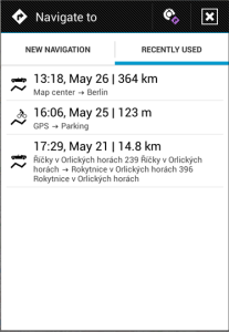

Recently Used
Do you often use navigation in Locus? Now will be your life with Locus easier. App remembers your last end points or whole navigation route. So you can very quickly define navigation route.
OSRM navigation engine
You can also improve computing of navigation route. Locus supports high-performance OSRM rng engine which works with free data from OpenStreetMap.
Backend engine for computing of navigation can be changed in: Settings > Navigation > Compute source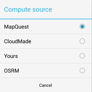
Text to speech
New version comes with improved TTS (Test To Speech) manager and positive news for Locus free users. TTS function is now available in both Free and Pro versions.
Geocaching
![]() Locus keeps in mind users which manage thousands of caches. Icons of points will become smaller, when you zoom-out. You get better overview because you can see position of points and also the map in the background. Listing tab in geocaching screen has improved HTML viewer and for this reason it’s possible to swipe between tabs in this screen.
Locus keeps in mind users which manage thousands of caches. Icons of points will become smaller, when you zoom-out. You get better overview because you can see position of points and also the map in the background. Listing tab in geocaching screen has improved HTML viewer and for this reason it’s possible to swipe between tabs in this screen.
Advanced function
CSV and TCX export
As you probably know Locus supports for example export to the KML or GPX format. Now you can export your data to the simple CSV format. This can be useful for following data processing. Supported is also Garmin TCX format for exporting recorded tracks.
EPSG codes
In new version you set arbitrary coordinates system based on EPSG codes. For more info see
https://docs.locusmap.eu/doku.php/manual:custom_coordinate_systems
For advanced users can be also useful new lines tools which give possibility to compute intersection two lines.


