Dear Locusers,
as you probably know we release new version about every month. And because new month is here also the new version Locus was released. Version 3.3.0 is small revolution in track management and brings new auto zooming feature.
Point and track manager
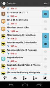
Do you remember an ugly checkboxes in the list of points and tracks? Did you know how to show data on a map? They’re gone now and are replaced with eye symbol or checkbox when you decide for bulk edit or export. Also the names of points are more visible.

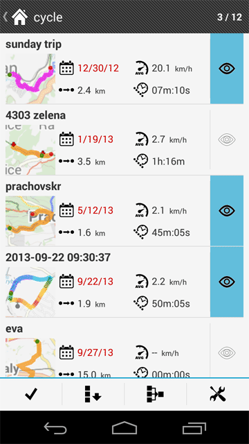
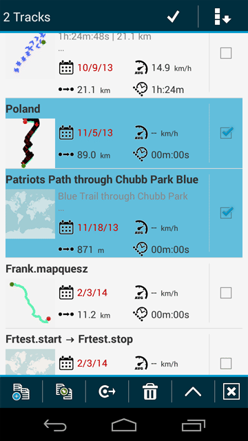
But the list of track has more improvements. With the new version you can see basic statistic about track without opening the details and small map thumbnail shows you the location of track. Let’s try to tap on the map thumbnail and Locus displays whole track over the map. Multi select for bulk edit or export is similar to list of points. Tap on tools button in bottom panel – select the tracks and choose action you want to perform.
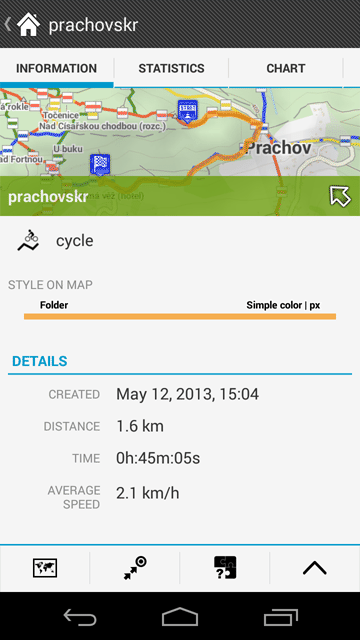
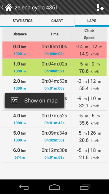
Track screen and lap statistics
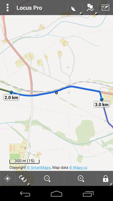
The big changes come with the track screen which looks similar to point screen. There are new tabs that show basic data, detailed statistic and the last tab brings the laps information – the most wanted feature of sport enthusiast. Select the length of lap or track part and Locus splits the important statistic between the particular parts. You can even show the specific track section on the map.
Autozoom
Locus has already offered auto-zoom in previous versions but this feature was complicated to use. For this reason we’ve prepared automatic auto-zoom feature (Menu > Settings > Maps – advanced > Autozoom). If it enabled Locus automatically change to zoom of map based on your speed which can be very useful for guiding or navigation.
Enjoy it
Your Locus team


25 Comments
Looks very cool. But in my track list, all thumbnails are just pictures of the map of the world with no track data.
Hi,
the thumbnails are generated when you create or save new track. So open detail track screen > open edit and save it. Generation of thumbnail is complicated process and is performed only when track is saved.
Hi, Voldy,
this is actually not quite correct - all I have to do is tap on a track in the list, wait until the map at the top is displayed, and hit the "Back" button.
Regards,
Jochen
Hi Jochen,
of-course you're right I didn't realized it. Thank you for correction! :)
The new tracks screen looks great :-) I gave just one small question - how do I select an individual point of the track? For example to edit its location.
Hi,
open details of track > from bottom menu choose "Edit on map" > select point of track (using arrows or taping o it ) and finally edit the point.
Please would it be possible to add a date format for the data screen as I split my tracks into folders and would prefer the DD/MM/YY option.
And if possible a compact view that doesn't show the thumbnails so you can get more on screen, as it was in the last version.
Thanks.
Epic software, by the way. I've tested many like Backcountry and Orux and Locus is the winner for many reasons.
Hi,
not sure if I understand correctly. Every track has information when was create and it is placed near the thumbnail icon. For second idea please create feature request on our help desk, where other users can vote for it: https://help.locusmap.eu/
Thanks
Bonjour,
Depuis la mise à jour android de ma tablette Samsung Galaxy note je n'ai plus accès aux cartes satellites Bing Google sat ...
Avez vous une solution.
Il s'agit de locus pro .
Merci et bonne journée
Pierre
Bonjour,
Google Maps ne sont pas au moins deux ans pris en charge car les conditions d'utilisation. Vous avez probablement utilisé non pris en charge complémentaire sur la carte: tordre qui n'est pas développé par l'équipe de Locus.
Merci de votre compréhension
Cordialement
--- EN---
Hi,
Google maps are not at least two years supported because terms of use. You've probably used unsupported add-on Map-tweak which is not developed by Locus team.
Thank you for understanding
Regards
After update to version 3.3.0 I see only two of my private maps, from 51 of them.
How to solve this problem?
Txanx!
Hi Marcel,
I'm sorry for troubles. There is really bug in the latest 3.3.0 version -> it'll be fixed in next 3.3.1 version.
Thank you for understanding
Best regards
Petr
Petr, great program I love it!
With the new update to 3.3.0 I lost the ability to autozoom. I click it on as you direct but the zoom never changes, I had the zoom setting just right and now there is no autozoom at all, i even tried to clear all temporary data.
regards,
Joe
Hi,
this feature was replaced by Auto-Zoom feature that changes the zoom automatically based on your speed. You can enable it in Menu > Settings > Map advanced -Auto zoom
Recorded Track is a Track.
Recording Track is a Active Track.
Saved Tracks are Trails or Traces
Tracks in database are Trails.
A track is red color by default.
Trails are blue color by default.
Is there no distinction between [a Track] and [Traces] ?
Hi,
I'm sorry but I don't understand the question. Basically we call every line data like "track". Is it wrong? So there is not difference between recorded track or saved, imported track in "Track manager"
Hi, I'm sorry.
In Locus App,
(1) "Recorded track" and "Track recording" are drawn with red color in map viewer.
(2) "Saved track" and "imported track" and "manually created track" are drawn with blue color in map viewer.
So there is difference between (1) and (2)
is not ?
Hi,
every track in Locus has two possibilities for its appearance (open details of track and choose tab "Appearance").
The first possibility is the appearance defined by whole folder or you can define specific style for specific track. See https://docs.locusmap.eu/doku.php?id=manual:data:how-to_change_style_track
When you submit SAVE for recorded track you can choose (in the latest version 3.3.1) if you want to use style of folder or style of track. The default color is the blue one. For this reason have your saved track the blue color.
Thank you for your replay
In Locus App,
(1) “Track recording” is red color in map viewer.
(2) “Recorded track” and “imported track” and “manually created track” are blue color in map viewer.
(3) “Route” is pink color in map viewer.
So there is difference between (1), (2), and (3)
is not ?
What difference between (1), (2), and (3) ?
Point and track manager
is this correct [Points and tracks manager] ?
Impossible to access parameters of automatic zoom on my wiko rainbow
Hi
in last version was replaced previous Auto-Zoom feature with new one that changes the zoom automatically based on your speed. You can enable it in Menu > Settings > Map advanced -Auto zoom
I wish to add EPSG:5179 Map to LocusMap
UTM-K (GRS80), Naver Map in Korea
EPSG:5179
http://onetile4.map.naver.net/get/47/0/0/{$z}/{$x}/{$y}/bl_vc_bg/ol_vc_an
Can you add map in Locus?
Please~~
After upgrading to version 3.3.1 map rotation doesn't work. As I turn I want the map to rotate so I always have the view of traveling up the screen.
Has anyone else reported this?
Hi,
Sorry for troubles but please focus on topic on help desk page https://help.locusmap.eu/responses/map-rotation-not-working-after-upgrate-to-331
Thank you
Petr