
Shading, vector world map and bunch of improvements
It’s been more then month since previous Locus version. I’m anyway very very glad to introduce a new version that brings many interesting features. I’m sure you’ll like it. And what are the most interesting features?
Map shading (feature of Locus PRO)
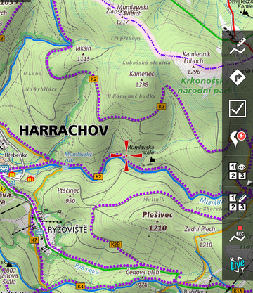
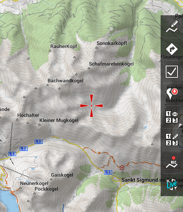
The most interesting news are ability to enable shading for all Online (since Android 3.0+) and Vector maps. Shading is completely without the need of an internet and it’s based on downloaded elevation files.
Currently you have to download them (HGT files) manually (or thanks to Fill altitude feature at specific place). Later, these files will be available for download in Locus Store.
Support for Personal maps is also planned, don’t worry.
Speed of vector maps & world map
We’re also aware of speed of vector maps. In a new version will be another improvements in vector maps speed mainly between levels 10 – 14. Hope these critical levels will be now much more usable.
Also, because levels 1 – 8 are usually very empty and mainly very slow, we prepared a small surprise. In Locus Store > Maps is now for Free download, overview map of whole world. The map has around 15 MB, so we really suggest to download it. This map will cover really whole World and will be automatically used without the need to do anything from you. Everytime you zoom out to level 8 and below, the World map will appear to give you a nice and fast overview of mother Earth.
Satellite and Compass screen
How often you search with compass and need to check what the he** is wrong with GPS? Or just need to enable GPS in Locus and also check an orientation etc? It will be very easy now.
We took both screens, and placed them into the screen with two tabs. Simple right? There is of course more improvements on both screens, but point is simple. You may work with Compass screen and also with Satellite screen at once, without need to crazy tapping …
Automatic turn On of the screen (feature of Locus PRO)
Saving battery is our highest priority. Battery is crucial when hiking in the wild. For this purpose we prepared a new feature that allows automatically turn On screen, when you’re near waypoint you guide on or during navigation when some turn come closer. This is especially useful on bike during a ride.
As a small bonus, we created ability to turn On/Off screen by two swipes gesture before top proximity sensor of your device.
Improved Text-to-speech system
Using Text-to-speech for navigation is very useful. It gives freedom to say whatever is needed and usually exists TTS Engines for every language. Problem is that they usually do not speak correctly.
Because of this, we prepared a new system that will be automatically used when you’ll use TTS for navigation. The system is actually available only for English, German, Czech and Japan TTS. If you want to know more, follow this link . Same if you want to contribute another language.
Is that all?
Sure not, there is much more …
- points that change at zoom level 12 and below to small dots are now much better visible
- switching of vector maps is now more simple (mainly for external themes)
- login over OAuth is now directly in Locus (to prevent problems on various web browsers)
- you may enable low or high contrast style on maps
- added support to choose what value will be visible above and below of guiding line
- fixed many problems like incorrect sorting of vector maps in Quick map switch, export of whole track folder, incorrect hiding points from folder after import, thanks to hard work of a few users, improved translation in whole application and much more
- and yes, one small sad news on the end. Since this version, Locus do not support Android version 2.1


14 Comments
Hi,
Nice New features especially shading for vector maps. I found the menu Tod actjvate shadibg, but where to get those hgt files? Would be nice to geht a small howto.
Kind regards,
Joachim
Downloading *.hgt files is still very tricky but we’re preparing new system for next months. Anyway there is workaround how to get hgt data:
- Menu > More > Add newroute & measure
- Create arbitrary track which cover your area of interest > save it
- Go to the Data manager > select crated track > click on tools button and select “Fill altitude”
- Then choose Offline and submit downloading of needed hgt files.
Using this system you can download hgt files for your area
Thanks Menion.
Locus is the best Android experience, better than Android itself !
So so so glad I found Locus during my early smartphone days - best android app for mapping / walking / geo-caching. Love it. Keep up the great work.
Absolute cool! I downloades the .hgt files with "DEM1 - World Elevation Data" from play.Google. DEM1 is a Downloader for hgt-files. If you click the advertising banner inside DEM1 you come to its full mode and can edit the Lat/Lon-quadrant or choose via built in map.
In Locus you put the hgts into: /locus/data/srtm, restart Locus and anable the shading in Map > Extended > Map Shading.
Do I understand correctly that the World map is supposed to be activated automatically when no other Card is showing at Level 8 or lower? It doesn't do so, I have to select it manually.
Yes it should work in the way you described: select Locus vector map and zoom-out. For zoom-levels < 9 locus automatically switch vector map to world map. Please note: It depends, how did you get the world map. Best solution is to download it from Locus store. Go to the Menu > Store > Maps > Vector maps free > chose World map (it needs restart of Locus after downloading).
Locus automatically download it and place on into correct directory - note: map will not appear in list of vector maps.
Works like a charm.
Using DEM1 to get the .hgt - files (see thomas above) is a PITA (not good). You only get one tile at a time,...
It would be perfect if my downloaded maps could use the height Information AND if it were possible to download the .hgt - files ALONG A TRACK or WAYPOINTS, just like the maps.
Map shading on higher zoom levels:
Map shading works fine until I zoom deeper in - then it is no more rendered. I would like to see the mapshading at higher zoomlevels. How can I adjust at whith zoom level the shading disappears?
Thanx,
Thomas
I second the question from Thomas. Why does the hillshading disappear in the higher zoom levels? Is this a bug or intended? Is there a config switch to switch it on permanently?
Hello jjensson,
Shading works only for zoom-levels <= 15. This is not technology problem we can offer shading for higher zoom-levels. We thing that shading for higher levels has no reason because for the most of places you lost the perspective. The result of shading for higher levels is only gray tile without any terrain information. Or am I wrong?
Well, i just compiled a map (bitmap) with Maperitive/MOBAC with the zoom levels 12, 14, 16 & 18. On the Samsung XCover2 the shading is still very readable on zoom level 16. On my computer screen (24") even on zoom 18 the shading is readable and you can get a sense of the relief. So i don't think you are right.
It would be useful, if this function is user configurable, so that i could decide if it goes until zoom 14 or beyond. And besides, if there's no penalty in processing power, it could be enabled for all zoom levels per default.
As it is now, it's confusing - when you zoom in, you abruptly lose any sense of relief and everything turns flat. I know there are elevation lines, but they are more difficult to read - doesn't work for a quick glance.
Please consider this for the next release.
Regarding the zoom level 'issue':
the way it was implemented is just right in my point of view:
1. the inverted maps (night mode) are usually just black if there is no structure in the map at high zoom levels. Thats a big advantage because it saves a lot of battery while tracking a tour. I generally use the app on night mode only (even at noon). If you would still see shading at high zoom levels the background wouldnt be black anymore => higher energy consumption.
2. as Voldy pointed out already shading on a very high zoom level won't give you any additional useful information.